Wyalusing, Pennsylvania facts for kids
Quick facts for kids
Wyalusing, Pennsylvania
|
|
|---|---|
|
Borough
|
|
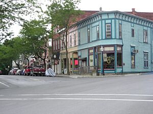
Downtown Wyalusing in July 2012
|
|
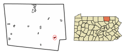
Location of Wyalusing in Bradford County, Pennsylvania.
|
|
| Country | United States |
| State | Pennsylvania |
| County | Bradford |
| Area | |
| • Total | 0.79 sq mi (2.06 km2) |
| • Land | 0.73 sq mi (1.88 km2) |
| • Water | 0.07 sq mi (0.18 km2) |
| Elevation | 705 ft (215 m) |
| Population
(2010)
|
|
| • Total | 596 |
| • Estimate
(2019)
|
555 |
| • Density | 764.46/sq mi (295.19/km2) |
| Time zone | UTC-5 (Eastern (EST)) |
| • Summer (DST) | UTC-4 (EDT) |
| ZIP code |
18853
|
| Area code(s) | 570 |
| FIPS code | 42-86656 |
|
Pennsylvania Historical Marker
|
|
| Designated: | March 15, 1949 |
Wyalusing is a small town, called a borough, in Bradford County, Pennsylvania, United States. It is part of Northeastern Pennsylvania. In 2010, about 596 people lived there.
Contents
Wyalusing's Past
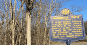
Wyalusing has a very long history. It was first known as M'chwihilusing. A historic path, the Wyalusing Path, connected this area to a Native American village called Canaserage. This village is now Muncy.
Before 1750, Wyalusing was called Gahontoto. It was home to the Tehotachsee tribe of Native Americans. Sadly, this small tribe was later completely taken over by the Cayuga tribe.
In 1765, a group of Moravian Christian Munsees started a settlement here. They were a peaceful group and named their town Friedenshütten, meaning "Tents of Peace". This settlement lasted for several years. In 1772, the group moved to Ohio. Later, in 1792, the chief of the Cayugas and about 20 other families rebuilt the town.
In the 1800s, Wyalusing began to grow. It became a busy place for shipping logs and other goods on the Susquehanna River. In 1820, the Welles Mill was built along Wyalusing Creek. This made Wyalusing a great area for farming. In 1887, Wyalusing officially became a borough. Many buildings from the late 1800s and early 1900s are still on Main Street today.
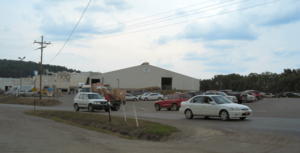
Wyalusing is home to one of the largest beef processing plants on the East Coast. This is the Cargill regional beef plant. It is located just a few miles outside of town. A local family, the Taylors, started this plant in the late 1970s. It began as a small meat processing business.
Over time, it grew into a huge company worth millions of dollars. Today, it employs over 1,200 people from the area. Cargill is a major supplier of ground beef to large grocery stores. These include Wegmans, Giant, and Shop Rite. In 2002, the Taylor family sold their business to the Cargill corporation. Cargill is one of the biggest privately owned companies in the United States.
Where Wyalusing Is Located
Wyalusing is in the southeastern part of Bradford County. It sits on the northeast bank of the Susquehanna River. This is where the Susquehanna River meets Wyalusing Creek.
The town is surrounded by Wyalusing Township. To the west, across the Susquehanna River, is Terry Township.
U.S. Route 6 runs through the middle of Wyalusing. This road follows the Susquehanna River. It goes southeast about 24 miles to Tunkhannock. It also goes northwest about 15 miles to Towanda. Towanda is the main town of Bradford County.
Pennsylvania Route 706 starts in Wyalusing and heads northeast. It leads about 37 miles to U.S. Route 11 and Interstate 81 near New Milford.
The United States Census Bureau says Wyalusing covers about 0.79 square miles (2.1 square kilometers). Most of this area is land, with a small part being water.
People of Wyalusing
| Historical population | |||
|---|---|---|---|
| Census | Pop. | %± | |
| 1890 | 438 | — | |
| 1900 | 525 | 19.9% | |
| 1910 | 580 | 10.5% | |
| 1920 | 628 | 8.3% | |
| 1930 | 709 | 12.9% | |
| 1940 | 706 | −0.4% | |
| 1950 | 612 | −13.3% | |
| 1960 | 685 | 11.9% | |
| 1970 | 723 | 5.5% | |
| 1980 | 716 | −1.0% | |
| 1990 | 686 | −4.2% | |
| 2000 | 564 | −17.8% | |
| 2010 | 596 | 5.7% | |
| 2019 (est.) | 555 | −6.9% | |
| Sources: | |||
In 2000, there were 564 people living in Wyalusing. They lived in 264 households. Most people were White. There were also small numbers of African American and Native American residents. Some people were from two or more races. A small percentage of the population was Hispanic or Latino.
About 23% of households had children under 18. The average household had about 2 people. The average family had about 2.75 people.
The population included people of all ages. About 20% were under 18. About 25% were 65 or older. The average age in Wyalusing was 45 years old.
Fun Things to See and Do
You can visit beautiful places like the Wyalusing Rocks. Another great spot is the Marie Antoinette Lookout.
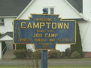
Wyalusing also has fun community events. These include the Fall Festival and Street Fair. There's also the Wyalusing Firemen's Parade. You can enjoy the Camptown Races and the Wyalusing Wine Festival too.
Learning in Wyalusing
Students in Wyalusing attend schools in the Wyalusing Area School District.
Local News
Wyalusing has its own newspaper, The Rocket Courier. This paper was created when The Wyalusing Rocket (started in 1887) joined with The Wyoming County Courier (started in 1923). The Rocket Courier covers news for Wyalusing and nearby towns. It is printed in Wyalusing every Thursday morning.
Another newspaper, The Daily Review, also covers Wyalusing. It was started in Towanda in 1879. This paper serves Bradford and Sullivan counties in Pennsylvania. It also covers Tioga County in New York.
Local Winery
The Grovedale Winery takes part in the yearly Wyalusing Valley Wine Festival. This festival is put on by the Wyalusing Valley Museum Association. At the festival, you can taste wines, enjoy food, and dance. Many wineries from Northeastern Pennsylvania attend each year.
Famous People from Wyalusing
- Joyce Steele (1935-2019), a player in the All-American Girls Professional Baseball League.
- Lucas Steele, an actor nominated for a Tony award.
- Philip Van Doren Stern (1900-1984), an author and historian. He wrote the original story for the movie It's a Wonderful Life.
- Johnny Swendel (1927-2022), a country music artist.
See also
 In Spanish: Wyalusing (Pensilvania) para niños
 | Janet Taylor Pickett |
 | Synthia Saint James |
 | Howardena Pindell |
 | Faith Ringgold |


