
Kittanning (village) facts for kids
Quick facts for kids
Kittanning Village
Kit-Han-Nee
|
|
|---|---|
|
Historic Native American village
|
|
.jpg)
Plaque at the site of Kittanning Village
|
|
| Etymology: Unami: kithanink kit- 'big' + hane 'mountain river' + -ink (suffix used in place names). "The main river" | |

Location of Kittanning Village in Armstrong County, Pennsylvania
|
|
.svg)
Location of Pennsylvania in the United States
|
|
| State | Pennsylvania |
| Present-day Community | Kittanning, Pennsylvania |
| Founded | 1724-1725 |
| Demolished | 8 September 1756 |
| Population | |
| • Estimate
(1754)
|
300-400 |

Kittanning, also known as Kithanink in the Lenape language, was an important Native American village in the 1700s. It was located on the Allegheny River in what is now Kittanning, Pennsylvania. The village was at the end of the Kittanning Path, a major trail used by Native Americans. This trail connected the Ohio River and Susquehanna River areas.
Kittanning was one of several large, independent "Indian republics." These were communities made up of different Native American groups. Many residents were survivors of diseases or conflicts. They were often refugees seeking a new home.
During the French and Indian War, Kittanning became a base for Delaware and Shawnee warriors. They launched raids from here against British settlements. However, Pennsylvania troops, led by Colonel John Armstrong, destroyed the village on September 8, 1756.
Contents
What Does the Name Kittanning Mean?
The name Kithanink comes from the Lenape language. It means 'on the main river.' The word kit- means 'big,' and hane means 'mountain river.' The suffix -ink is used in place names.
The Lenape people considered the Allegheny and Ohio Rivers as one main river. Other tribes, like the Six Nations, called the town Adego or Atiga. The French later used names like "Attigué" or "Attiqué."
History of Kittanning Village
How Kittanning Was Established in 1724
The village was first settled around 1724. Delaware (Lenape) people from the Turtle and Turkey clans moved there. They were moving west because European settlements were growing near Shamokin.
Kittanning grew to be one of the largest Native American villages west of the Allegheny Mountains. By 1756, it had an estimated 300–400 residents. In 1754, an interpreter named Conrad Weiser said that the road to Ohio was "an old and frequented road." He noted that the Shawnese and Delawares had moved there over thirty years before.
By 1727, Pennsylvania traders were active in the Allegheny area. Anthony Sadowski set up a trading post in Kittanning in 1729. In 1731, traders reported about 50 families and 150 men, mostly Delaware, living there. The population grew as more Lenape, Cayugas, Senecas, and Shawnees arrived. They were escaping a smallpox outbreak in 1733 and a drought in 1741. This made Kittanning a diverse community.
The Shawnee also created smaller villages nearby. These included Neucheconeh's Town, later called Chartier's Town. Kittanning and its nearby villages were known as "Allegeney" or "Allegania."
Trade with New France

The French started contacting people in Kittanning around 1726. In 1728, the Marquis de Beauharnois, Governor of New France, wrote about the Shawnees. He said they were friendly with the French and had a village on the Ohio River. This village had over 150 men and their families.
In 1731, English traders reported that a French gentleman visited Kittanning. He wanted to know how many English traders were there. He also wanted to understand the feelings of the Native Americans. This French visitor was believed to be bringing messages from the Governor of Montreal.
Requests to the Pennsylvania Government, 1733-1743
In 1733, Shawnee chiefs in Kittanning sent a message to Governor Gordon. They complained about traders selling too much rum without licenses. They asked for permission to destroy the rum barrels. They also asked for special permission for Peter Chartier, a trusted trader, to continue trading.
In 1734, the Shawnee chiefs sent another letter. They asked Pennsylvania to limit rum sales to no more than 30 gallons, twice a year. They explained that too much drinking was causing problems for their people.
By 1743, Governor Thomas learned that traders were being warned to leave Allegheny. Rumors were spreading that Native Americans planned to attack white people. The Governor thought Peter Chartier might be spreading these rumors to scare traders. Chartier was unhappy that the Pennsylvania government would not control alcohol sales. In 1745, he led over 400 Pekowi Shawnees out of Pennsylvania. They went to found a new community in Kentucky.
Visit by Céloron de Blainville in 1749

In the summer of 1749, Pierre Joseph Céloron de Blainville led a large group down the Ohio River. His mission was to claim the territory for New France. He buried lead plates and nailed copper plates with royal symbols to trees.
Céloron arrived at Kittanning, which he called "Attigué," on August 6, 1749. He found the village mostly empty, with only a Lenape chief and two young men. Céloron told them he came to speak to the nations of the Ohio River. He invited them to a council in a nearby village. He asked them to listen carefully without interrupting.
Captives Held at Kittanning
At the start of the French and Indian War, Pennsylvania was not ready for battle. Shingas and Captain Jacobs led many Shawnee and Delaware raids. They attacked British settlements, killing and capturing hundreds of colonists. Kittanning was used as a gathering point for these raids. It was also where prisoners were brought after being captured.
At the time of the Kittanning Expedition in 1756, about one hundred prisoners might have been held there. Some captives later shared their stories about being in the village:
- James Smith likely spent three weeks in Kittanning in June 1755. He described it as an "Indian town" on the Allegheny River.
- Marie Le Roy and Barbara Leininger, both 12 years old, were held at Kittanning from December 1755 until the village was attacked. They had to work hard, tanning leather, clearing land, and planting corn. They often suffered from lack of food, sometimes eating only acorns, roots, and grass. When the village was attacked, they were moved away for safety. After the attack, they were brought back to the burned village.
- John Cox was captured in February 1756. He reported seeing about 100 Delaware warriors and 50 English prisoners in Kittanning. He later escaped in August 1756.
- Simon Girty, then 15, was captured in July 1756. He was taken to Kittanning with his family. He later became a notable figure in the American Revolutionary War.
- Hugh Gibson, 14, was captured in July 1756. He was brought to Kittanning and adopted by Pisquetomen, a Delaware chief. Gibson was in Kittanning during the attack. He later escaped in March 1759 and walked 250 miles to Fort Pitt.
By the summer of 1756, over three thousand colonists had been killed or captured. Many settlements were burned or abandoned. Between July 1755 and September 1756, Native American groups carried out at least 78 raids in Pennsylvania. These raids killed 484 Pennsylvanians and captured at least 202.
The Destruction of Kittanning in 1756

In response to the raids, Governor Robert Hunter Morris ordered new forts to be built. However, Native American warriors and French troops attacked and burned Fort Granville in August 1756. Governor Morris then wanted to strike back at the Native Americans' home territory. He offered a reward for the deaths of Shingas and Captain Jacobs.
George Croghan reported that an Indian scout found 140 warriors and over 100 English prisoners at Kittanning. A map of Kittanning was drawn by John Baker, a former captive. It showed the village was about 1000 meters long. It also showed the homes of important leaders like Shingas and Captain Jacobs. The map showed 40 houses grouped by clans, overlooking cornfields.
In August, Lieutenant Colonel John Armstrong led 300 Pennsylvania troops. They attacked and destroyed Kittanning on September 8, 1756. Many houses caught fire, and barrels of gunpowder stored inside exploded. One account said, "Nearly thirty houses were fired, and while they were burning, the ears of Col. Armstrong and his men were regaled by the successive discharges of loaded guns, and still more so by the explosion of sundry bags and large kegs of powder stored away in every house."
Armstrong described the "vast Explosion of sundry Bags and large Cags of Gunpowder." He noted that the Native Americans had enough ammunition for "ten Years War." When Captain Jacob's house exploded, a leg and thigh of an Indian and a child were thrown high into the air. A large amount of goods, recently given by the French, also burned. The sound of the main gunpowder storage exploding was heard as far away as Fort Pitt.
After the attack, many inhabitants returned and built new homes on the ashes. The town was briefly reoccupied. Some prisoners who tried to escape were brought back. The Native Americans then harvested their corn. They moved further west to Fort Duquesne, seeking permission from the French to resettle away from the British. Many of Kittanning's residents moved to other villages like Saucunk, Kuskusky, or Muskingum.
Fort Armstrong
The site of Kittanning was later used as a gathering place for Native American campaigns. In August 1763, warriors gathered there before attacking Colonel Henry Bouquet at the Battle of Bushy Run.
In 1774, the militia from Hannastown, Pennsylvania briefly stayed at the uninhabited site. Arthur St. Clair suggested building a fort and a town there for trade. However, the project was not approved by the assembly. The site was used as a temporary military camp during the American Revolutionary War in 1776.
In March 1779, George Washington ordered Colonel Moses Rawlings to build a stockade fort at Kittanning. This task was given to Daniel Brodhead. On July 1, Brodhead named it "Fort Armstrong" in honor of Colonel Armstrong. The fort was abandoned in November 1779 because the soldiers were needed elsewhere. Attempts to re-establish the garrison failed due to supply issues. In July 1782, Seneca warriors led by Guyasuta gathered at the site before attacking Hannastown, Pennsylvania.
Ruins of Fort Armstrong, including a well, could still be seen as late as 1875.
Images for kids
-
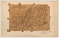
Map showing the French occupation of the Ohio Valley, based on Christopher Gist's surveys of 1751, showing "Kittaning" to the left of the center of the page.
-
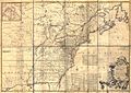
1755 map by John Mitchell showing "Kittanning, English settlement of some years ago", upper left of map's center.


