Hughesville, Pennsylvania facts for kids
Quick facts for kids
Hughesville, Pennsylvania
|
|
|---|---|
|
Borough
|
|

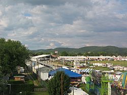
The Lycoming County Fair in Hughesville
|
|

Location of Hughesville in Lycoming County, Pennsylvania
|
|

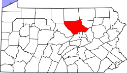
Map of Pennsylvania highlighting Lycoming County
|
|
| Country | United States |
| State | Pennsylvania |
| County | Lycoming |
| Settled | 1816 |
| Incorporated | April 23, 1852 |
| Area | |
| • Total | 0.65 sq mi (1.67 km2) |
| • Land | 0.65 sq mi (1.67 km2) |
| • Water | 0.00 sq mi (0.00 km2) |
| Elevation
(borough benchmark)
|
580 ft (180 m) |
| Highest elevation
(northwest borough boundary)
|
582 ft (177 m) |
| Lowest elevation
(Muncy Creek)
|
562 ft (171 m) |
| Population
(2020)
|
|
| • Total | 2,154 |
| • Density | 3,339.53/sq mi (1,289.62/km2) |
| Time zone | UTC-5 (Eastern (EST)) |
| • Summer (DST) | UTC-4 (EDT) |
| ZIP code |
17737
|
| Area code(s) | 570 |
| FIPS code | 42-36160 |
| GNIS feature ID | 1213971 |
Hughesville is a small town, also called a borough, in Lycoming County, Pennsylvania, United States. In 2020, about 2,155 people lived there. It is part of the larger Williamsport, Pennsylvania area.
Contents
History of Hughesville
Hughesville got its name from Jeptha Hughes. He bought land in 1816 and started planning a town called "Hughesburg." Later, in 1820, he sold the land to Daniel Harrold.
The town slowly grew around a gristmill, which is a mill that grinds grain. Jacob Clayton built this mill. A tavern (like an inn or restaurant) opened in 1820. Ten years later, a general store was built. The first doctor, John W. Peale, came to Hughesville in 1828.
Hughesville officially became a borough on April 23, 1852. The first dentist opened an office in 1853. A lawyer came to Hughesville in 1875.
Early Industries and Growth
In the early days, Hughesville's businesses helped local farmers and residents. These included a factory that made chairs in 1829. A shop that built wagons opened in 1830. There were also several places that made alcohol (distilleries).
Other important businesses were a sawmill and a planing mill (for wood). A furniture factory also operated in the town. In 1891, Hughesville got modern services like electricity and running water.
Geography and Location
Hughesville is located in Pennsylvania. It is completely surrounded by Wolf Township. If you were to fly like a bird, Hughesville is about 130 miles (209 km) northwest of Philadelphia. It is also about 165 miles (266 km) east-northeast of Pittsburgh.
The United States Census Bureau says the borough covers about 0.6 square miles (1.6 square kilometers). All of this area is land.
Hughesville is famous for hosting the Lycoming County Fair. It is also home to the East Lycoming School District.
Population and People
| Historical population | |||
|---|---|---|---|
| Census | Pop. | %± | |
| 1860 | 363 | — | |
| 1870 | 456 | 25.6% | |
| 1880 | 899 | 97.1% | |
| 1890 | 1,358 | 51.1% | |
| 1900 | 1,528 | 12.5% | |
| 1910 | 1,650 | 8.0% | |
| 1920 | 1,577 | −4.4% | |
| 1930 | 1,868 | 18.5% | |
| 1940 | 1,947 | 4.2% | |
| 1950 | 2,095 | 7.6% | |
| 1960 | 2,218 | 5.9% | |
| 1970 | 2,249 | 1.4% | |
| 1980 | 2,174 | −3.3% | |
| 1990 | 2,049 | −5.7% | |
| 2000 | 2,220 | 8.3% | |
| 2010 | 2,128 | −4.1% | |
| 2020 | 2,155 | 1.3% | |
| 2021 (est.) | 2,140 | 0.6% | |
| Sources: | |||
In 2000, there were 2,220 people living in Hughesville. These people lived in 967 homes, with 608 of them being families. Most of the people (98.60%) were White.
About 29% of homes had children under 18 living there. Nearly half (48.9%) were married couples. About 15.5% of homes had someone living alone who was 65 or older.
The average age of people in Hughesville was 38 years old. About 24.9% of the population was under 18.
The average income for a household in Hughesville was $29,361 in 2000. For families, the average income was $37,905. About 6.9% of all people in Hughesville lived below the poverty line. This included 4.5% of those under 18.
See also
 In Spanish: Hughesville (Pensilvania) para niños
 | Sharif Bey |
 | Hale Woodruff |
 | Richmond Barthé |
 | Purvis Young |


