Mount Porte Crayon facts for kids
Quick facts for kids Mount Porte Crayon |
|
|---|---|
| Highest point | |
| Elevation | 4,770 ft (1,450 m) |
| Prominence | 1,590 ft (480 m) |
| Parent peak | Allegheny Front |
| Naming | |
| Etymology | David Hunter Strother's pseudonym Porte Crayon |
| Geography | |
| Parent range | Allegheny Mountains |
| Climbing | |
| Access | off-trail hike |

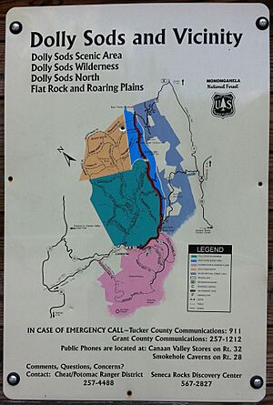
Mount Porte Crayon is a mountain located in the Roaring Plains Wilderness. This area is part of the Monongahela National Forest in West Virginia, USA. The mountain stands tall at about 4,770 feet (1,450 m) (1,454 meters). It marks the highest point of the Allegheny Front in this region.
The mountain gets its name from a 19th-century writer and artist, David Hunter Strother. He lived from 1816 to 1888. Strother was known by his pen name, "Porte Crayon." This is a French term meaning "pencil holder." He created many early drawings and paintings of West Virginia's beautiful landscapes.
Contents
About Mount Porte Crayon
Mount Porte Crayon is the sixth highest point in the state of West Virginia. It is also the most northern of the state's top ten highest peaks. This mountain is the highest spot on the Roaring Plains. This area is a natural extension of the Dolly Sods Wilderness.
The flat area around the summit is very high. It is the largest high plateau in eastern North America. About 5.5 square miles of this plateau are at or above 4,500 feet (1,372 meters) in elevation.
Special Protected Area
The summit area of Mount Porte Crayon is a special protected zone. It is an 8.11-acre (32,800 m2) area called a Research Natural Area. This means it is kept safe for scientific study. It protects a native red spruce forest that grows on the mountaintop.
This forest is home to some rare animals. These include the endangered northern flying squirrel and the endangered Cheat Mountain salamander. Mount Porte Crayon is also where three different river systems begin. It is the highest point on the Eastern Continental Divide in West Virginia, Maryland, and Pennsylvania.
Mountain History
Mount Porte Crayon has an interesting history, especially how it got its name. It also has a special nature preserve.
How the Mountain Got Its Name
In 1940, a group of people who admired David Hunter Strother formed a group called the "Porte Crayon Memorial Society." They learned about this tall mountain, which was then measured at 4,760-foot (1,451 m). It was in the heart of the highland area that Strother loved to draw.
The society worked hard to have the mountain named in his honor. On July 5, 1940, a special ceremony was held at the top of the mountain. People had to hike for three hours to reach the spot. The ceremony included a speech about Strother, singing the national anthem, and raising the Star-Spangled Banner on a spruce flagpole.
Nature Conservancy Preserve
In 2008, a group called the Nature Conservancy created a new preserve. This preserve covers 100 acres (0.4 km2) of land. It has a mix of red spruce and northern hardwood trees. There are also shrub-filled pastures that are slowly turning back into forests.
This preserve is called the Mount Porte Crayon Preserve. It is located around the southern side of the mountain. It also borders the Roaring Plains Wilderness for more than three-quarters of a mile. This preserve is part of a bigger plan by the Nature Conservancy. They aim to protect 1,800 acres (7 km2) of land around Mount Porte Crayon over time.
Mountain Weather
Mount Porte Crayon is known for its tough weather. Conditions can change very quickly, and strong winds are common. The winds usually blow from the west. They are so strong, especially in winter, that they can bend the red spruce trees. This makes the trees grow mostly on their east side.
The summit is often covered in clouds. Fog can become very thick, making it hard for hikers to know where they are going.
Temperatures and Snowfall
Temperatures at the top of the mountain are quite cold. The average monthly temperature stays below freezing for four months of the year. In the middle of winter, during very cold spells, afternoon temperatures can stay below 0 °F (−18 °C) (about -18 °C). Mornings can drop to −25 °F (−32 °C) (about -32 °C). These cold temperatures, combined with strong winds, create dangerously low wind chills.
In the summer, afternoons usually reach the upper 60s °F (around 20 °C). Mornings are cooler, in the low to mid 50s °F (around 11.5 °C). Thunderstorms happen often and can be strong. Lightning strikes from clouds to the ground can be dangerous.
The mountain gets a lot of rain and snow. About 65 inches (1625 mm) of precipitation falls each year, spread out evenly across the months. Snowfall is also heavy, averaging about 170 inches (430 cm) per season. Some winters can bring 275 inches (700 cm) or more of snow. Snow usually starts falling in early October and stops by early May.
Even in the coldest months, there can be periods of rain and warmer temperatures (around 50s °F or 10-15 °C). This is because the mountain is not too far north (39 degrees N latitude). This allows warmer, moist air from the Gulf of Mexico to reach it. These warmer, rainy periods often reduce the amount of snow on the ground. This means the ground can switch between being covered in snow and being bare.
The snow usually builds up to about three feet (1 meter) deep by late February. In very cold and snowy winters, the snow can get to 4 feet (1.3 m) or more deep. This deeper snow can last into March and melt by mid-April.
Recreation and Future Plans
Mount Porte Crayon offers challenges for hikers and has been part of discussions about future development.
Hiking Challenges
Mount Porte Crayon is one of West Virginia's hardest peaks to reach. It is far from any public road or even a hiking trail. To reach the summit, hikers must use the U.S. Forest Service's Flat Rock Run Trail or Roaring Plains Trail. This hike is more than five miles long and involves climbing about 2,500-foot (762 m).
A difficult part of the hike is a three-mile "bushwhack." This means hikers must push through dense spruce trees. About half a mile of this is very thick with spruce and rhododendron plants. Reaching the top of Mount Porte Crayon is only for experienced hikers. Its difficulty should not be underestimated. There are good views from a rocky cliff called Thunderstruck Rock. This spot is about a quarter mile from the summit.
The Nature Conservancy's preserve is open to the public. Visiting it involves a three-mile round-trip hike. This hike starts from where the Flat Rock Run and Roaring Plains trails meet. It follows the Mount Porte Crayon Grade, which used to be a railroad path. Now, it is an unmarked trail that leads into the preserve.
Ski Resort Discussions
Mount Porte Crayon has been part of discussions about building a ski resort. A developer named Bill Bright, who created other resorts like Winterplace, has shown interest in the area. The proposed ski area is rumored to be called "Almost Heaven Mountain Resort." It is planned to have the largest vertical drop south of New York.
 | Kyle Baker |
 | Joseph Yoakum |
 | Laura Wheeler Waring |
 | Henry Ossawa Tanner |


