
Brush Mountain (Blair County, Pennsylvania) facts for kids
Quick facts for kids Brush Mountain |
|
|---|---|

The higher southwest section of Brush Mountain looking southwest toward Altoona. Interstate 99 is lower right. The Allegheny Front is center right, with Blue Knob in the center.
|
|
| Highest point | |
| Elevation | 2,557 ft (779 m) |
| Geography | |
| Location | Blair County, Pennsylvania, U.S. |
| Parent range | Appalachian Mountains |
| Topo map | USGS Millheim (PA) Quadrangle |
| Climbing | |
| First ascent | unknown |
Brush Mountain is a long mountain ridge in the Appalachian Mountains of central Pennsylvania, USA. It sits between the Allegheny Front to the west and Tussey Mountain to the east. This ridge is found along the Little Juniata River and Sinking Run. It's the most western ridge in this part of the Ridge-and-Valley Appalachians. The western side of the ridge separates the Logan Valley from the Sinking Valley.
Brush Mountain is completely located in Blair County. It stretches for about 30 miles (44 km). It starts near Tyrone, where the Little Juniata River cuts through it, forming a gap. From there, it goes south towards Altoona, then turns north to the Canoe Valley. At this point, the ridge changes its name to Canoe Mountain.
No big roads or rivers cut through Brush Mountain. There's a small lake called Kettle Reservoir that collects water from the mountain. A secondary road, Kettle Road, also runs near the dam. You can also see a major power line crossing the ridge in two places.
Contents
Fun Facts About Brush Mountain
Brush Mountain is a popular spot for soaring birds and people who fly gliders. They use the air currents that rise along the mountain slopes to stay in the air. This ridge is part of a long chain of mountains that goes all the way south to Tennessee. There's a small break in the mountain chain near the south end of Brush Mountain. The ridge continues about 10 km south as Dunning Mountain.
Pennsylvania State Game Lands Number 166 is located on Brush Mountain. This is a protected area for wildlife and outdoor activities. It covers parts of Brush Mountain south of Sinking Hollow and also Canoe Mountain.
Tornado on the Mountain
On July 19, 1996, a small tornado touched down on Brush Mountain. It happened just after 11:00 a.m. near Altoona. This tornado was an F1, which means it was a weaker type of tornado. It knocked down many trees along the mountain. It also caused minor damage to some homes in its path. The tornado traveled for about 1.5 miles and was about half a mile wide. This was one of several tornadoes that hit different counties in Pennsylvania that day.
How Brush Mountain Was Formed
Brush Mountain is part of the Ridge-and-Valley Appalachians. This is a large area of mountains in the Appalachian Mountain Range. Brush Mountain, along with nearby Bald Eagle Mountain and Tussey Mountain, is made of very old rocks. These rocks formed during the Paleozoic Era. They include sandstone from the Bald Eagle Formation and shale and siltstone from the Juniata Formation. There's also tough Quartzite from the Tuscarora Formation.
These rock layers were pushed and folded during a time called the Appalachian orogeny. This happened in the Permian period, millions of years ago. After they were folded, wind and water slowly wore them down to what we see today.
The Tuscarora Quartzite is very strong and doesn't wear away easily. The Bald Eagle Sandstone is also tough. These two strong rock layers form the double ridge shape of Brush Mountain. The Tuscarora Quartzite usually forms the very top of the ridge because it's the hardest rock.
On the north end of the mountain, the rock layers stand almost straight up. This gives the mountain a double-crested shape, similar to the Bald Eagle ridge further north. As you go south, there are some cracks in the rock called fault lines. Here, the rock layers tilt down towards the west. This tilt makes the Tuscarora Formation more parallel to the steeper western side of the mountain. The tough rock protects this slope from erosion, making the southern part of the ridge higher.
Images for kids
-
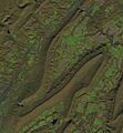
2016 Landsat image of Sinking Valley and Brush Mountain
-
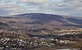
Brush mountain looming over Hollidaysburg


