
Seneca Rocks facts for kids
Quick facts for kids Seneca Rocks |
|
|---|---|

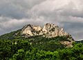
The North and South Peaks viewed from the west
|
|

Location in West Virginia
|
|
| Location | Pendleton County, West Virginia |
| Nearest city | Seneca Rocks, West Virginia |
| Range | Appalachians |
| Coordinates | 38°50′05″N 79°21′58″W / 38.83472°N 79.36611°W |
| Climbing type | traditional crag |
| Height | 900 feet above stream level |
| Pitches | 4 |
| Ratings | 5.0-5.13 with most routes in 5.7-5.11 range |
| Grades | I and II |
| Rock type | Tuscarora quartzite |
| Quantity of rock | months worth (over 375 routes) |
| Development | well developed |
| Cliff aspect | east and west |
| Season | spring to fall |
| Ownership | National Forest |
| Camping | Seneca Shadows & 2 private campsites in town (all paid) |
| Classic climbs |
|
| Stars | |
Seneca Rocks is a huge rock formation in West Virginia, USA. It's a famous place for rock climbing and a local landmark. The South Peak is special because it's the only peak on the East Coast that you can only reach by climbing. Many people love to challenge themselves on its steep rock faces.
You can easily see Seneca Rocks from several highways. These roads meet in a small town also called Seneca Rocks, West Virginia. This town is part of the Spruce Knob–Seneca Rocks National Recreation Area within the Monongahela National Forest.

Contents
What are Seneca Rocks?
Seneca Rocks is part of a group of ridges called the River Knobs. These ridges look like "razorbacks" or "fins." Seneca Rocks stands almost 900 feet tall above where Seneca Creek meets the North Fork of the South Branch of the Potomac River. It looks over the small community of Seneca Rocks.
The Rocks have two main parts: a North Peak and a South Peak, with a dip in the middle. There used to be a tall, thin rock pillar called "the Gendarme" in that dip, but it fell down in 1987.
How Seneca Rocks Formed
The amazing Seneca Rocks formed over millions of years! About 440 million years ago, this area was covered by an ancient ocean. Fine sand settled at the bottom, forming layers. Over time, these layers turned into a hard rock called quartzite.
Later, about 200 million years ago, the land was pushed up and folded. This created a giant bulge in the earth, like a huge wrinkle. The rock layers were tilted almost straight up. Wind and water slowly wore away the softer rocks around them. The super-hard quartzite, however, resisted erosion. This left behind the tall, striking cliffs we see today.
A Look Back in Time
Early People and Explorers
Long ago, Native Americans camped near Seneca Creek, at the base of the Rocks. A famous path called the "Seneca Trail" followed the Potomac River. Different tribes, like the Algonquian and Tuscarora, used this trail for trading and traveling. When the Seneca Rocks Visitor Center was built, people found signs of two old villages, one of which was active about 700 years ago.
The first European explorers came to this area around 1746. The first settlers arrived about 15 years later. An artist named David Hunter Strother visited the Rocks around 1853 and drew pictures of them. These drawings were later published in a popular magazine.
First Climbs
No one knows for sure who first climbed Seneca Rocks. Native Americans likely climbed them long before Europeans arrived. However, the first recorded sign of a climb was an inscription that said "D.B. September 16, 1908." This was found by climbers in 1939.
The first documented climb with ropes happened in 1935. Paul Bradt and Florence Perry climbed the North Peak. In the 1930s and 1940s, only a few climbers, mostly from Washington, D.C., and Pittsburgh, tried to climb Seneca Rocks.
Training for War
During World War II, in 1943 and 1944, the U.S. Army's 10th Mountain Division used Seneca Rocks for training. Soldiers learned how to climb mountains for battles in Italy. They left behind thousands of metal spikes called pitons. Some of these pitons can still be seen today, and one rock face was even named "The Face of a Thousand Pitons."
Protecting the Rocks
In 1965, the Spruce Knob–Seneca Rocks National Recreation Area was created to protect this special place. The government bought the Rocks in 1969.
The first visitor center opened in 1978 but was damaged by a flood in 1985. Then, in 1987, "the Gendarme," a tall rock pillar, fell down. In 1992, the visitor center was destroyed by a fire. The current visitor center, called the Seneca Rocks Discovery Center, was finished in 1998.
Rock Climbing Adventures
Seneca Rocks is a very popular spot for rock climbing. There are over 375 different climbing routes! These routes range from easy (5.0) to very difficult (5.14b).
There are two climbing schools right in Seneca Rocks: Seneca Rocks Climbing School and Seneca Rocks Mountain Guides. They teach people how to climb safely, from beginners to advanced climbers. Other climbing guides from nearby states also bring people to climb here.
Both the East and West sides of the North and South Peaks have routes that are up to 300 feet long. The South Peak is the tallest peak east of Devils Tower in Wyoming that requires technical climbing to reach the top. Because of how the rock formed, there are many vertical cracks that are great for climbing and placing safety gear.
Legends of the Rocks
A popular story about Seneca Rocks is "The Betrothal of Snow Bird, Princess of the Seneca Indians." It was written in 1932.
In this legend, Princess Snow Bird, who loved climbing the rocks, challenged her father, Chief Bald Eagle. She would climb to the top, and her suitors would follow. The first one to reach her hand would become her husband. Out of seven suitors, only one made it to the top. From their high spot, Snow Bird and her future husband looked out over the land they would one day rule.
However, this is just a story. The Seneca people actually lived in what is now western New York state. Any Seneca tribesmen who passed through this area were just traveling. Also, the historical Chief Bald Eagle was a Lenape leader from Pennsylvania, not a Seneca chief from West Virginia.
Images for kids
-
Seneca Rocks viewed from the parking lot
-
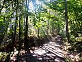
View of the trail / road (Roy Gap Road) to the South Peak area in the morning
-
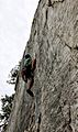
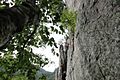
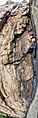
Climber on "Castor," east face of Seneca Rocks
-
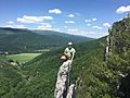
Climber on top of "Bring on the nubiles", west face of Seneca Rocks
-
East face of Seneca Rocks
-
Vertical panorama of "Triple S" on the west face of Seneca Rocks
-
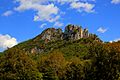
Seneca Rocks in the Fall
-
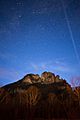
Seneca Rocks night sky, as seen from the town of Seneca Rocks, West Virginia in the Monongahela National Forest.
-
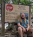
According to the warning sign near the top of North Peak, 15 people have died in falls while climbing Seneca Rocks since 1971.


See also
Nearby State Parks
