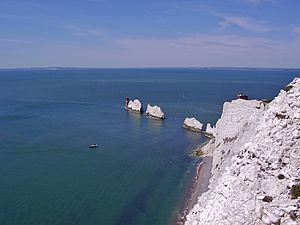
The Needles facts for kids
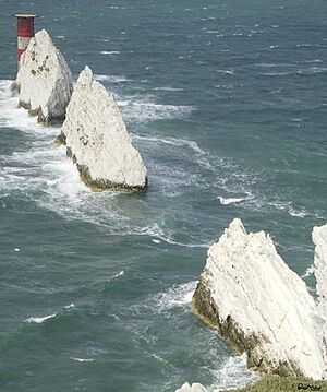
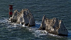
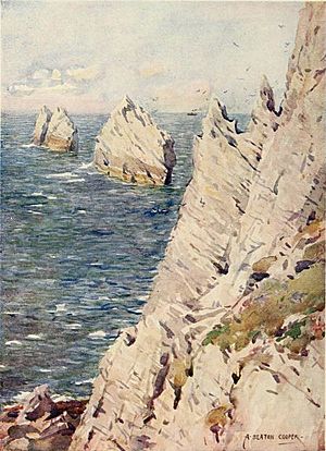
The Needles are three tall, pointy rock formations made of chalk. They stick out of the sea about 30 meters (100 feet) high. You can find them off the western tip of the Isle of Wight in the United Kingdom. They are very close to Alum Bay and are part of Totland, the westernmost area of the Isle of Wight.
At the very end of these rocks, a Needles Lighthouse stands tall. It was built in 1859 and has been working automatically since 1994. This means no one lives there to operate it anymore!
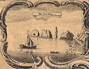
The Needles got their name from a fourth rock that looked like a needle. This rock was called Lot's Wife. It fell down during a big storm in 1764. Even though the rocks left today don't really look like needles, the name has stayed.
The Needles were even shown on a TV show called Seven Natural Wonders in 2005. They were featured as one of the amazing natural sights of Southern England.
Contents
Visiting The Needles
The Needles are a very popular place for tourists to visit. They are located just southwest of Alum Bay. You can take fun boat trips from Alum Bay to see the Needles up close. These rocks and the lighthouse are famous symbols of the Isle of Wight. Many visitors take pictures of them, and you can find them on lots of souvenirs sold around the island.
The main attractions on the land nearby include two old gun batteries. There is also a special station where rockets used to be tested. Four Coastguard cottages, owned by the National Trust, are also there.
A group called the National Coastwatch Institution also has a station at the Needles. It is located near the New Battery and the old Rocket Testing Site on High Down.
At the top of the cliff in Alum Bay, there is a small amusement park called The Needles – Landmark Attraction. You can ride a Chairlift from the park down to the beach.
Military History of The Needles
The Needles area was used as a place for gun batteries for a long time. This started in the 1860s and continued until 1954, when the batteries were closed down.
A nearby area called High Down was used to test rockets for the British ICBM program. From 1956 to 1971, Black Knight and Black Arrow rocket engines were tested here. At its busiest in the early 1960s, about 240 people worked at this site. The rockets themselves were built in East Cowes. These rockets later helped launch the Prospero X-3 satellite into space.
Today, the National Trust owns the site, and anyone can visit it. You can still see the concrete parts of the old rocket site. However, the buildings that were not as strong have either been taken down or worn away by the weather.
In 1982, Prince Charles officially opened the restored Needles Old Battery. There are also underground rooms where rockets were tested. These rooms are being fixed up so people can see them. The first part of this restoration was finished in 2004.
Getting to The Needles Batteries
You can get to the old gun batteries by car, walking, bike, or bus. There is a paved road leading up to The Old and The New batteries. However, you have to walk from a car park to reach the battery site. The area can be dangerous in strong winds. Because of this, it is closed to visitors if the winds are stronger than force 8.
In spring and summer, the Southern Vectis bus company runs special open-top buses. This route is called "The Needles Tour." The bus goes along the cliff edge to reach the Battery. This road is only for buses.
The Needles Tour also stops at other places like Alum Bay, Totland, Colwell Bay, Fort Victoria, Yarmouth, and Freshwater Bay. These tour buses are the only vehicles allowed on the road from Alum Bay. The only exceptions are vehicles for National Trust staff or disabled visitors who have arranged it beforehand. This is because the narrow road is very close to the cliff edge and is considered too dangerous for many cars.
The Isle of Wight Coast Path starts or ends at the Coastguard Cottages in this area.
How The Needles Formed
The Needles have their pointy shape because of their unique geology. The layers of rock, called strata, were pushed and folded very strongly during a time called the Alpine Orogeny. This made the chalk layers stand almost straight up.
This chalk rock formation runs through the middle of the Isle of Wight. It goes from Culver Cliff in the east to the Needles in the west. Then, it continues under the sea to the Isle of Purbeck. There, it forms Ballard Cliff (near Swanage), Lulworth Cove, and Durdle Door. At Old Harry Rocks, you can see these rock layers changing from flat to nearly vertical.
Just beyond the Needles is a shifting pile of pebbles called the Shingles. This shoal is about three miles long and lies just under the waves. Many ships have crashed on the Shingles over the years.
See also
 In Spanish: The Needles para niños
 | James B. Knighten |
 | Azellia White |
 | Willa Brown |


