
Eastern Yar facts for kids
Quick facts for kids River Yar |
|
|---|---|

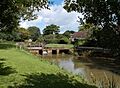
The Eastern Yar at Brading marshes
|
|
| Native name | Eastern Yar |
| Country | England |
| Region | Isle of Wight |
| Physical characteristics | |
| Main source | Niton, Isle of Wight |
| River mouth | The Solent Bembridge Harbour, Isle of Wight |
| Length | 20 km (12 mi) |
| Basin features | |
| Tributaries |
|
The River Yar is a river located on the Isle of Wight in England. It starts its journey in a special valley called a chalk coomb. This valley is found near St. Catherine's Down and the village of Niton, which is close to the southern tip of the island.
From its source, the river flows across older rocks from the Lower Cretaceous period. It then passes through a gap in the island's central ridge, which is made of younger chalk from the Upper Cretaceous period. This gap is at a place called Yarbridge. The river continues its path across an area that used to be a large tidal bay called Brading Haven. Today, this area is mostly drained land. Finally, the River Yar reaches Bembridge Harbour in the northeast of the island, where it flows into The Solent.
For most of its length, the river travels through quiet, natural areas. It's a peaceful river that plays an important role in the local environment.
Contents
What's in a Name?
The Isle of Wight is quite unique because it has two rivers with the same name! To avoid confusion, this river is often called the Eastern Yar. This helps people tell it apart from the other river, which is known as the Western Yar. So, if you hear someone talk about the "Eastern Yar," they mean this one!
The River's Journey
From Source to Sea
The River Yar begins its flow high up on St. Catherine's Down. This area is known for its chalky hills and beautiful views. The water collects in a natural dip in the land, forming the very start of the river.
As the river travels, it moves through different types of land. It crosses ancient rock formations that tell stories of Earth's past. The river then finds its way through a natural opening in the island's central chalk hills. This opening is like a gateway for the river.
Passing Through Brading Haven
One interesting part of the River Yar's journey is its path through what was once Brading Haven. This used to be a large area of tidal water, like a mini-sea bay. Over time, much of this area was drained to create farmland. The river now flows through these reclaimed lands before reaching the sea.
Reaching the Solent
The journey of the River Yar ends at Bembridge Harbour. Here, its waters mix with the sea in The Solent. The Solent is the strait of water that separates the Isle of Wight from mainland England. This is where the river's fresh water meets the salty ocean.
Features Along the Way
The Weir at Alverstone
As the River Yar flows through the village of Alverstone, you can find a small structure called a weir. A weir is like a mini-dam that controls the flow of water. At Alverstone, this weir helps to direct some of the river's water.
This water is then used to power a traditional water mill. Water mills use the force of flowing water to turn a wheel, which can then power machinery. It's a clever way people used to harness nature's energy!
Images for kids
-
River Yar at Alverstone
-
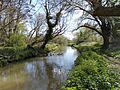
Riverside scene in early spring, near Alverstone


