
Mineral County, West Virginia facts for kids
Quick facts for kids
Mineral County
|
||
|---|---|---|

Mineral County Courthouse in Keyser
|
||
|
||

Location within the U.S. state of West Virginia
|
||
 West Virginia's location within the U.S. |
||
| Country | ||
| State | ||
| Founded | February 1, 1866 | |
| Seat | Keyser | |
| Largest city | Keyser | |
| Area | ||
| • Total | 329 sq mi (850 km2) | |
| • Land | 328 sq mi (850 km2) | |
| • Water | 1.4 sq mi (4 km2) 0.4%% | |
| Population
(2020)
|
||
| • Total | 26,938 | |
| • Estimate
(2021)
|
26,857 |
|
| • Density | 81.88/sq mi (31.61/km2) | |
| Time zone | UTC−5 (Eastern) | |
| • Summer (DST) | UTC−4 (EDT) | |
| Congressional district | 1st | |

Mineral County is a special area called a county in the state of West Virginia. It is part of the Cumberland metropolitan area, which includes Cumberland, Maryland. In 2020, about 26,938 people lived here. The main town and county seat is Keyser. Mineral County was officially created in 1866.
Contents
History of Mineral County
Early History and Native Americans
Long ago, for thousands of years, Indigenous peoples lived in the highlands along the rivers in this area. Scientists who study old cultures, called Archeologists, have found items from the Adena culture. These items are from a time between 1000 BC and 200 BC.
The Adena people were one of the first Native American groups to build large earth mounds. They used these mounds for special ceremonies and for burying their dead. You can find signs of their culture all over West Virginia. Other Native American groups lived here after the Adena people.
Later, the Haudenosaunee (also known as the Iroquois Confederacy) moved into the Ohio Valley. They were looking for new places to hunt. By the 1600s, they had taken over other tribes and kept this area for hunting.
How Mineral County Was Formed
Mineral County was created after West Virginia became a state in 1863. It was formed in 1866 from a part of Hampshire County. The county got its name because it had many valuable minerals, especially coal. Even though coal is a type of rock, not a mineral, the name stuck!
A very important event for the county was when the main line of the Baltimore and Ohio Railroad arrived in 1842. The county seat, Keyser, was even named after a leader of this railroad company.
In 1863, West Virginia's counties were divided into smaller areas called civil townships. This was meant to help local governments. But it was hard to manage in a state with many rural areas. So, in 1872, the townships became magisterial districts. Mineral County started with seven townships. One was returned to Hampshire County, and the other six became magisterial districts. Later, in the 1980s, these six districts were combined into three new ones: District 1, District 2, and District 3.
Geography and Nature
Mineral County covers about 329 square miles. Most of this is land (328 square miles), and a small part is water (1.4 square miles).
Mountains of Mineral County
The Allegheny Front is a big mountain range in West Virginia that runs through Mineral County. The highest point in the county is called "the Pinnacle." It is about 3,104 feet above sea level. From an old fire tower there, you can see four states: Pennsylvania, Maryland, West Virginia, and Virginia. The Allegheny Front is the largest mountain in the county. Its northern part is also known as Green Mountain.
On top of the Allegheny Plateau are the towns of Sulphur City and Elk Garden, West Virginia. The Potomac River Valley is to the west and north of the mountain. The New Creek Valley is to the east.
Knobly Mountain is another long mountain in Mineral County. It stretches from the Grant County line in the south to the Potomac River in the north near Ridgeley, West Virginia. To the east of Patterson Creek Valley are smaller hills that form the border with Hampshire County.
Rivers and Waterways
- The North Branch Potomac River is the biggest river nearby. It forms the northern border of the county and the state border with Maryland. Jennings Randolph Lake is located on this river.
- New Creek flows into the North Branch Potomac River at Keyser. Its source is in Grant County, West Virginia. New Creek provides water for the city of Keyser.
- Patterson Creek flows into the Potomac River east of Cumberland, Maryland. Its source is also in Grant County, West Virginia. The Patterson Creek area covers two-thirds of Mineral County.
Minerals Found Here
Natural gas can be found east of the Allegheny Front. There are also deposits of iron ore. Mineral County no longer produces iron. However, you can still see several old iron furnaces from the 1800s.
Population and People
| Historical population | |||
|---|---|---|---|
| Census | Pop. | %± | |
| 1870 | 6,332 | — | |
| 1880 | 8,630 | 36.3% | |
| 1890 | 12,085 | 40.0% | |
| 1900 | 12,883 | 6.6% | |
| 1910 | 16,674 | 29.4% | |
| 1920 | 19,849 | 19.0% | |
| 1930 | 20,084 | 1.2% | |
| 1940 | 22,215 | 10.6% | |
| 1950 | 22,333 | 0.5% | |
| 1960 | 22,354 | 0.1% | |
| 1970 | 23,109 | 3.4% | |
| 1980 | 27,234 | 17.9% | |
| 1990 | 26,697 | −2.0% | |
| 2000 | 27,078 | 1.4% | |
| 2010 | 28,212 | 4.2% | |
| 2020 | 26,938 | −4.5% | |
| 2021 (est.) | 26,857 | −4.8% | |
| U.S. Decennial Census 1790–1960 1900–1990 1990–2000 2010–2020 |
|||
In 2020, there were 26,938 people living in Mineral County. Most residents were White (about 91.9%). About 2.7% were African American, and 0.4% were Asian. About 1.15% of the population was of Hispanic or Latino origin. The average age of people in the county was 44.6 years.
Economy and Jobs
Industrial Parks
The Mineral County Development Authority manages special areas for businesses called industrial parks. One is near Keyser and has access to train lines. Another is near Fort Ashby and has fast internet. These parks help create jobs and bring new businesses to the county.
Education in Mineral County
The schools in Mineral County are managed by Mineral County Schools.
High Schools
Mineral County has two high schools:
Colleges
Potomac State College is a two-year college located in Keyser, West Virginia. It is built on the site of Fort Fuller, an important place during the Civil War.
Transportation
Airport
The Greater Cumberland Regional Airport is located in Wiley Ford.
Public Transportation
The Potomac Valley Transit Authority provides public transportation services. This means people can get around using buses or other shared rides.
Rail Travel
CSX train lines run along the Potomac River on the northern border of the county. You can catch an Amtrak train in Cumberland, Maryland, which is just across the river from Ridgeley, West Virginia. The Keyser railroad station closed in the 1980s.
Main Roads
|
|
Parks and Fun Places
Larenim Park
This park is owned by Mineral County and is about 365 acres. It has two picnic areas, an amphitheater that can seat 600 people, and fields for Little League and softball. You can also go fishing in two flood control dams that are stocked with fish. The whole park is open for public hunting with a permit. There are about 5 miles of trails for walking. An arboretum (a place with many different trees) is being built here. Larenim Park is also home to a local theater group called McNeill's Rangers.
Barnum Whitewater Area
This area is about 40 acres and is owned by Mineral County. It has 4 miles of rail/trail for walking or biking. It also has about 1 mile of river frontage on the North Branch of the Potomac River. This is a great place for trout fishing and offers 7 miles of whitewater rafting and canoeing for families. You can also hunt on the state lands around it.
MINCO Park
Owned by Mineral County Schools, MINCO Park is 13.5 acres. It has two picnic areas with 50 picnic tables, nine cabins, a dining hall, a chapel, a meeting room, and bath/shower facilities.
Van Myra Campground
This campground is owned by the State of West Virginia and leased by Mineral County. It is about 10 acres and has three picnic tables, four small picnic shelters, and a picnic area.
Dam Site #21
This 178-acre area is owned by Mineral County and has no special facilities. It has a 10-acre flood control dam where you can fish.
Jennings Randolph Lake
Jennings Randolph Lake is named after Senator Jennings Randolph. It was built in 1981 by the United States Army Corps of Engineers on top of the old town of Shaw, West Virginia. The lake is near Elk Garden. It is a large lake, covering 952 acres with over 13 miles of shoreline, offering lots of fun activities.
The Howell Run Picnic Area overlooks the lake and has 40 picnic spots, two shelters, a playground, and restrooms. The Howell Run Boat Launch has a two-lane concrete ramp for boats. The Robert W. Craig Campground is on a high ridge overlooking the dam. It has 87 campsites, water, hot showers, restrooms, and a playground. There's also a 3/4-mile interpretive trail to explore. The West Virginia Overlook has a two-level Visitor Center. You can also see Waffle Rock, a unique natural rock formation, from the Overlook.
Golf Courses
- Polish Pines – This is a private golf course with nine holes and a club house.
- Mill Creek – This is another private golf course with nine holes and a club house.
Libraries
Mineral County has the Keyser-Mineral County Public Library. It opened in 1937. In 1962, it moved to a bigger building. The library gets money from the West Virginia Library Commission, Mineral County Court, and Keyser City Council. Besides the main library in Keyser, there are also branches in Burlington and Fort Ashby.
There is also the Piedmont Public Library, which is supported by County United Way and the West Virginia Library Commission.
Communities in Mineral County
City
- Keyser (This is the county seat, the main town for county government)
Towns
Magisterial Districts
- District 1
- District 2
- District 3
Census-Designated Places
These are areas that are like towns but are not officially incorporated.
Unincorporated Communities
These are smaller communities that are not officially part of a city or town.
- Antioch
- Atlantic Hill
- Barnum
- Beryl
- Blaine
- Champwood
- Claysville
- Cross
- Dans Run
- Emoryville
- Foote Station
- Forge Hill
- Fountain
- Hampshire
- Hartmansville
- Headsville
- Keymont
- Laurel Dale
- Limestone
- Markwood
- Nethkin
- New Creek
- Oakmont
- Patterson Creek
- Reeses Mill
- Ridgeville
- Rocket Center
- Russelldale
- Short Gap
- Skyline
- Sulphur City
- Wagoner
Historical Sites to Visit
Mineral County has many interesting historical places:
- Carskadon Mansion
- Claysville Church
- Claysville Log House
- Fort Ashby
- Fort Cocke
- Fort Fuller
- Fort Ohio
- Fort Sellers
- Mineral County Courthouse (West Virginia)
- Nancy Hanks Birthplace
- New Creek Blockhouse
- Northwestern Turnpike
- Patterson Creek Manor
- Saddle Mountain
- Traveler's Rest
- Weaver's Antique Service Station
- Wind Lea
Notable People from Mineral County
Many interesting people have come from Mineral County:
- Colonel James Allen
- John Ashby
- Woodrow Wilson Barr
- Thomas Carskadon
- Henry G. Davis
- Thomas Beall Davis
- Lynndie England
- Henry Louis Gates
- Nancy Hanks Lincoln, mother of Abraham Lincoln
- Jonah Edward Kelley
- John Kruk
- Leo Mazzone
- Catherine Marshall
- Walter E. "Jack" Rollins
- Harley Orrin Staggers
- Harley O. Staggers Jr.
- Ken Ward Jr.
- Steve Whiteman
Images for kids
-
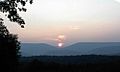
Saddle Mountain as viewed from Highland Acres Farm

See also
 In Spanish: Condado de Mineral (Virginia Occidental) para niños
