Brownsville, Pennsylvania facts for kids
Quick facts for kids
Brownsville, Pennsylvania
|
|
|---|---|
|
Borough
|
|
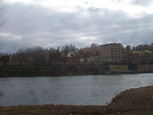
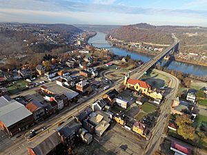
View of Brownsville from across the Monongahela River
|
|
| Etymology: Thomas Brown | |
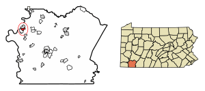
Location of Brownsville in Fayette County, Pennsylvania.
|
|
| Country | United States |
| State | Pennsylvania |
| County | Fayette |
| Established | 1785 |
| Area | |
| • Total | 1.09 sq mi (2.83 km2) |
| • Land | 0.98 sq mi (2.53 km2) |
| • Water | 0.11 sq mi (0.29 km2) |
| Population
(2020)
|
|
| • Total | 2,185 |
| • Density | 2,236.44/sq mi (863.10/km2) |
| Time zone | UTC-4 (EST) |
| • Summer (DST) | UTC-5 (EDT) |
| ZIP code |
15417
|
| Area code(s) | 724 |
| FIPS code | 42-09432 |
| GNIS feature ID | 1214026 |
Brownsville is a small town, called a borough, in Fayette County, Pennsylvania, United States. It was first settled in 1785. The town started as a trading post. It was a key stop for people moving west after the American Revolutionary War.
Brownsville is located about 40 miles (64 km) south of Pittsburgh. It sits on the east bank of the Monongahela River. The town covers about 1.09 square miles (2.83 km2). Most of this is land, but some is water from the river.
The area around Brownsville has many hills. This made Brownsville a natural center for transportation. It was a major hub for travelers and goods. Today, a railway bridge helps move coal trains. The toll road PA Route 43 connects Brownsville to Pittsburgh. The historic National Road (now U.S. Route 40) also passes through.
For a long time, Brownsville was an important industrial town. It was a market, a transportation center, and a place where people bought supplies for their journeys. It was also famous for building riverboats.
Contents
History of Brownsville
Early Days and Native American History
Long ago, before Europeans arrived, the land near the Monongahela River had several large mounds. These were built by ancient Native American groups, sometimes called Mound Builders. Early settlers thought these mounds were forts. This is why the area was first called "Redstone Old Fort."
In the 1600s, the land was mostly empty. Different Iroquoian peoples, like the Erie people and Wenro people, lived or hunted here. Later, tribes like the Delaware and Susquehannocks moved into the area.
During the French and Indian War in the 1750s, a British fort was built here in 1759. It was named Fort Burd. This fort was important because it was near a natural river crossing on Nemacolin's Trail. This trail was a key path to the west.
How Brownsville Got Its Name
In 1774, soldiers from Virginia stayed at the fort during a conflict called Lord Dunmore's War. George Washington owned a lot of land nearby.
After the American Revolution, a businessman named Thomas Brown bought land in the area. He saw that this spot was perfect for settlers heading west. Many travelers used the Ohio River and the Monongahela River. Because of him, the settlement became known as "Brownsville."
In the 1780s, Jacob Bowman bought land and built Nemacolin Castle. He ran a trading post, selling supplies to settlers.
Brownsville and the Whiskey Rebellion
Brownsville was also a meeting place during the Whiskey Rebellion in 1794. This was when people on the frontier protested a tax on whiskey. It was the first meeting of this protest.
A Hub for Western Travel
Brownsville was at the end of the main road network that led west. This road eventually became the National Pike, which is now U.S. Route 40.
Because of its location on the river, Brownsville became a major center for building boats. At first, they built keelboats and flatboats. Later, they started building steamboats. The town's industries used local coal and iron to make parts for these boats. Travelers used these boats to go to places like St. Louis and other ports on the Mississippi River. This was often safer and faster than traveling by land.
Steamboat Building Powerhouse
Brownsville quickly became a leader in steamboat building. In 1814, local workers built the Enterprise. This was the first steamboat powerful enough to travel all the way down the Mississippi River to New Orleans and then back upstream. This was a huge achievement!
From 1811 to 1888, boatyards in Brownsville built over 3,000 steamboats. These boats were used for passengers and to carry goods. Even after railroads became popular for passengers, steamboats were still important for moving heavy loads of minerals to the growing steel industries.
The First Cast Iron Bridge
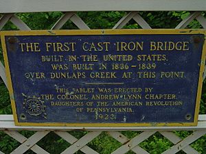
Brownsville is home to a very special bridge: the Dunlap's Creek Bridge. Built in 1839, it was the first all-cast iron arch bridge in the United States. It carried the National Pike over Dunlap's Creek. Even today, the bridge is still in use!
Changes and Decline
After 1853, when the Baltimore and Ohio Railroad reached the Ohio River, fewer people needed to outfit wagon trains in Brownsville.
However, Brownsville found a new role with the rise of the steel industry in Pittsburgh. It became a railroad yard and a center for making coke (a fuel used in steel production). The town grew and prospered through the early 1900s. In 1940, Brownsville had over 8,000 people.
After World War II, many people moved to suburbs. The steel and railroad industries also changed, causing many jobs to be lost in Brownsville starting in the 1970s. This led to a big drop in population. By 2010, the population was 2,331.
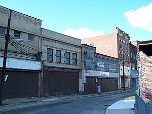
Today, Brownsville is working to rebuild. Some old buildings are empty, but the town is trying to bring new life to its historic areas.
Brownsville in Pop Culture
Brownsville has even played a part in music and TV!
- In 1958, the famous singer Ray Charles developed his hit song "What'd I Say" during a jam session in Brownsville.
- In 2019, Brownsville was the main filming location for the TV series I Am Not Okay with This, which came out on Netflix in 2020.
Geography of Brownsville
Brownsville is located at 40°1′12″N 79°53′22″W / 40.02000°N 79.88944°W. It sits on a bend in the Monongahela River. The river's action helped create flat areas near the shore, which were good for building. Most of the homes in Brownsville are built on higher ground above the business district.
Across the river in Washington County is a smaller town called West Brownsville. This area is flatter. Historically, this was a natural place to cross the river. A ferry, boat building, and later a bridge connected the two towns. When the U.S. government built its first major road, the National Road, Brownsville was an early destination.
Redstone Creek flows into the Monongahela River just north of Brownsville. Its name comes from the red sandstone in its bed. This creek was wide enough for settlers to build and launch many boats.
Population of Brownsville
Brownsville's population has changed a lot over the years.
- In 1810, there were 698 people.
- The population grew steadily, reaching its peak in 1940 with 8,015 people.
- By 2020, the population was 2,182.
Cool Places to See in Brownsville
Dunlap's Creek Bridge
The Dunlap's Creek Bridge (built in 1839) is part of U.S. Route 40. It crosses Dunlap's Creek in Brownsville. It's special because it's the oldest cast iron bridge still in use in the United States!
The Flatiron Building
The Flatiron Building (around 1830) is another historic spot. It's one of the oldest and most complete iron commercial buildings west of the Allegheny Mountains. It used to be a business building and even a post office. It's like an early version of the famous Flatiron Building in New York City.
The Brownsville Area Revitalization Corporation (BARC) helped save and restore this building. Inside, the Flatiron Building Heritage Center shows artifacts from Brownsville's past. It also has displays about the town's important coal and coke history. The Frank L. Melega Art Museum is also there, showing art about the coal and coke era.
Other Historic Sites
Brownsville has several other places listed on the National Register of Historic Places. These include:
- Bowman's Castle (also known as Nemacolin Castle)
- Brownsville Bridge
- St. Peter's Church
- Thomas H. Thompson House
There are also two national historic districts: the Brownsville Commercial Historic District and Brownsville Northside Historic District.
Education in Brownsville
The Brownsville Area School District serves Brownsville and nearby communities. The schools in the district are:
- Brownsville Area High School (grades 9–12)
- Brownsville Area Middle School (grades 6–8)
- Brownsville Area Elementary School (grades K–5)
Transportation in Brownsville
Brownsville is located on the Monongahela River. This river is a major waterway that connects to the Ohio River. The Monongahela River is deep enough for barges to travel. This allows for cheap transportation of goods to many cities across the United States.
The Brownsville Bridge, built in 1914, connects Brownsville to West Brownsville across the Monongahela River. In 1960, the Lane Bane Bridge was built nearby. This new bridge carries U.S. Route 40, helping to ease traffic.
Famous People from Brownsville
Many notable people have come from Brownsville, including:
- Benjamin W. Arnett (1838–1906), a civil rights activist and bishop.
- John Brashear (1840–1920), a famous astronomer and builder of scientific instruments.
- Thomas Brown (1738–1797), the founder of Brownsville.
- Vinnie Colaiuta (born 1956), a well-known jazz-rock-pop drummer.
- Doug Dascenzo (born 1964), a former Major League Baseball player.
- Bill Eadie (born 1947), a professional wrestler known as Ax of Demolition.
- Daniel French (1770–1853), a pioneer in steam engine design.
- Henry Miller Shreve (1785–1851), a pioneering steamboat captain and designer.
See also
 In Spanish: Brownsville (Pensilvania) para niños
 | Claudette Colvin |
 | Myrlie Evers-Williams |
 | Alberta Odell Jones |


