
Redstone Creek (Pennsylvania) facts for kids
Quick facts for kids Redstone Creek |
|
|---|---|


Location of Redstone Creek mouth
|
|
| Other name(s) | Tributary to Monongahela River |
| Country | United States |
| State | Pennsylvania |
| County | Fayette |
| City | Uniontown |
| Physical characteristics | |
| Main source | Georges Creek divide on west side of Chestnut Ridge about 3 miles east of Fairchance, Pennsylvania 2,370 ft (720 m) 39°49′03″N 079°41′25″W / 39.81750°N 79.69028°W |
| River mouth | Monongahela River about 0.25 miles north of Brownsville, Pennsylvania 744 ft (227 m) 40°02′09″N 079°52′32″W / 40.03583°N 79.87556°W |
| Length | 27.73 mi (44.63 km) |
| Basin features | |
| Progression | northwest |
| River system | Monongahela River |
| Basin size | 108.60 square miles (281.3 km2) |
| Tributaries |
|
| Waterbodies | Hutchinson Reservoir No.3 Hutchinson Reservoir No.2 Hutchinson Reservoir No.1 |
Redstone Creek is a stream in Fayette County, Pennsylvania. It flows into the Monongahela River. The creek is about 28.4 miles (45.7 km) (45.7 km) long. It starts on Chestnut Ridge and flows north through Uniontown. It reaches the Monongahela River near Brownsville.
This creek was very important in history. Its wide, calm waters near Brownsville made it a perfect spot for building boats. These boats included large steamboats, which are boats powered by steam engines. After 1811, many steamboats were built here. The creek's low banks and wide valley were ideal for launching and docking these big boats.
Brownsville, located where Redstone Creek meets the Monongahela River, became a major center for building boats. These boats, especially flatboats and paddlewheel steamboats, traveled far. They went all the way to New Orleans and even up the Missouri River. People started building flatboats here as early as 1782.
Redstone Creek played a key role in moving goods and settlers. It helped people travel west into the Mississippi Basin. Brownsville was a gateway for settlers heading to new lands. This included the Ohio Country and the Louisiana Territory. This continued until railroads reached the Missouri River around 1853. Brownsville was on the shortest land route across the Allegheny Mountains. These mountains were a big barrier for travel between the east and west.
Other Names for the Creek
Redstone Creek has also been known by another name. According to the Geographic Names Information System, it was historically called:
- Red Stone Creek
History of Redstone Creek

The first Europeans came to this area in the 1710s as traders. In 1717, European traders set up posts and settlements. This was after Michael Bezallion described the forks of the Ohio River.
European settlers began to arrive in 1748. The first Ohio Company, an English land company, received a large grant of land. This grant was for 200,000 acres (810 km2) in the upper Ohio Valley. The company started building a wagon road from Cumberland, Maryland to the Monongahela River. They hired a Delaware Indian chief named Nemacolin. He and a group of settlers, led by Captain Michael Cresap, began widening an old Indian trail. This trail is now known as Nemacolin's Trail.
The river crossing and flat lands at Redstone Creek were important. This spot was the easiest and shortest way for a wagon road to reach the river. Later, during a war, this spot was fortified as Fort Burd. Today, this place is Brownsville.
In the 1740s, the government bought lands beyond the Allegheny Mountains from Native American tribes. This gave England a claim to the lands in the Ohio Basin. Around 1748, the Ohio Company was formed. They began exploring and planning how to use the land rights they had bought. In 1750, the company hired Chief Nemacolin, a Delaware Indian. They also hired a farmer from Virginia who owned land in West Virginia.
Images for kids
-
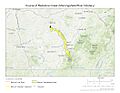
Course of Redstone Creek in Fayette County, Pennsylvania
-
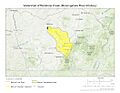
Watershed of Redstone Creek in Fayette County, Pennsylvania
.jpg)
.jpg)
