Monongalia County, West Virginia facts for kids
Quick facts for kids
Monongalia County
|
|||
|---|---|---|---|
|
|||
|
|||
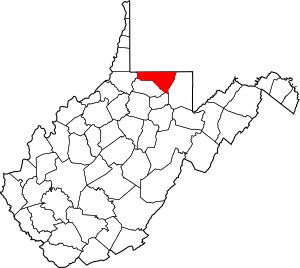
Location within the U.S. state of West Virginia
|
|||
 West Virginia's location within the U.S. |
|||
| Country | |||
| State | |||
| Founded | October 9, 1776 | ||
| Named for | Latin name for the Monongahela River | ||
| Seat | Morgantown | ||
| Largest city | Morgantown | ||
| Area | |||
| • Total | 366 sq mi (950 km2) | ||
| • Land | 360 sq mi (900 km2) | ||
| • Water | 5.8 sq mi (15 km2) 1.6%% | ||
| Population
(2020)
|
|||
| • Total | 105,822 | ||
| • Estimate
(2021)
|
106,387 |
||
| • Density | 296/sq mi (114/km2) | ||
| Time zone | UTC−5 (Eastern) | ||
| • Summer (DST) | UTC−4 (EDT) | ||
| Congressional district | 1st | ||
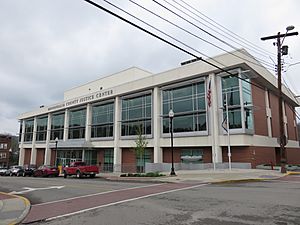
Monongalia County, often called Mon County, is a county in West Virginia, USA. It was founded in 1776. The main city and county seat is Morgantown.
In 2020, about 105,822 people lived here. This makes it West Virginia's third-largest county by population. Monongalia County is the biggest county in the North-Central West Virginia area. It is also part of the larger Morgantown metropolitan area.
Contents
History of Monongalia County
Monongalia County gets its name from the Monongahela River. The name "Monongalia" might be a slightly different spelling of "Monongahela." Another idea is that "-ia" was added to "Monongahela." This ending often means "land of" or "country of," like in "Arabia." So, it could mean "Land of the Monongahela."
How the County Was Formed
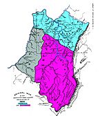
Monongalia County was created in 1776. Back then, it was part of Virginia. A large area called the District of West Augusta was split into three counties. These were Ohio, Yohogania, and Monongalia. All three were named after important rivers.
When Monongalia County was first formed, it was much larger. It included parts of what are now several other counties in West Virginia. These are Tucker, Randolph, Marion, Harrison, and Barbour. It also included parts of some counties in Pennsylvania.
In 1863, West Virginia divided its counties into smaller areas called civil townships. This was to help with local government. But it was hard to do in a state with many rural areas. So, in 1872, these townships became "magisterial districts."
Monongalia County first had seven districts: Battelle, Cass, Clay, Clinton, Grant, Morgan, and Union. Later, in the 1970s, these seven were combined into three new districts: Central, Eastern, and Western.
Geography and Nature
Monongalia County covers about 366 square miles. Most of this is land, with a small part being water.
Neighboring Counties
Monongalia County shares borders with several other counties:
- Fayette County, Pennsylvania (to the northeast)
- Greene County, Pennsylvania (to the north)
- Marion County (to the south)
- Preston County (to the east)
- Taylor County (to the southeast)
- Wetzel County (to the west)
Main Roads
Many important roads run through Monongalia County. These include major highways that connect it to other parts of the state and country:
Rivers, Streams, and Lakes
The county has many natural waterways, which are important for its environment and history:
- Aarons Creek
- Cam Harker Spring
- Cheat Lake
- Cheat River
- Deckers Creek
- Dunkard Creek
- Jakes Run
- Monongahela River
Population and People
| Historical population | |||
|---|---|---|---|
| Census | Pop. | %± | |
| 1790 | 4,768 | — | |
| 1800 | 8,540 | 79.1% | |
| 1810 | 12,793 | 49.8% | |
| 1820 | 11,060 | −13.5% | |
| 1830 | 14,056 | 27.1% | |
| 1840 | 17,368 | 23.6% | |
| 1850 | 12,387 | −28.7% | |
| 1860 | 13,048 | 5.3% | |
| 1870 | 13,547 | 3.8% | |
| 1880 | 14,985 | 10.6% | |
| 1890 | 15,705 | 4.8% | |
| 1900 | 19,049 | 21.3% | |
| 1910 | 24,334 | 27.7% | |
| 1920 | 33,618 | 38.2% | |
| 1930 | 50,083 | 49.0% | |
| 1940 | 51,252 | 2.3% | |
| 1950 | 60,797 | 18.6% | |
| 1960 | 55,617 | −8.5% | |
| 1970 | 63,714 | 14.6% | |
| 1980 | 75,024 | 17.8% | |
| 1990 | 75,509 | 0.6% | |
| 2000 | 81,866 | 8.4% | |
| 2010 | 96,189 | 17.5% | |
| 2020 | 105,822 | 10.0% | |
| 2021 (est.) | 106,387 | 10.6% | |
| U.S. Decennial Census 1790–1960 1900–1990 1990–2000 2010–2020 |
|||
Population in 2020
In 2020, the census counted 105,882 people living in Monongalia County. There were 42,710 households. Most people (85%) were White. Other groups included African American (3.9%), Asian (3.5%), and Native American (0.2%). About 6.1% of people were from two or more races. Hispanic or Latino people made up 3.1% of the population.
The average age of people in the county was 33 years old. The average income for a household was about $56,374.
Population in 2010
In 2010, the county had 96,189 people. The population density was about 267 people per square mile. Most people (91.0%) were white. Other groups included black or African American (3.6%) and Asian (3.1%). About 1.8% of the population was Hispanic or Latino.
The median age was 29.1 years. The average income for a household was $39,167. About 21.0% of the population lived below the poverty line.
Education in Monongalia County
The public schools in the county are managed by Monongalia County Schools. The county is also home to West Virginia University. This is the largest university in West Virginia, located in Morgantown.
Communities in Monongalia County
Monongalia County has several types of communities, from big cities to smaller, unincorporated areas.
Cities
- Morgantown (This is the county seat, where the main government offices are)
- Westover
Towns
Magisterial Districts
These are administrative areas within the county:
- Central
- Eastern
- Western
Census-Designated Places (CDPs)
These are areas that are like towns but are not officially incorporated:
- Brookhaven
- Cassville
- Cheat Lake
- Pentress
Unincorporated Communities
These are smaller communities that are not officially part of a city or town. There are many of them in Monongalia County:
- Arnettsville
- Baker Ridge
- Behler
- Bertha Hill
- Booth
- Bowlby
- Brewer Hill
- Browns Chapel
- Bula
- Canyon
- Cheat Neck
- Chestnut Ridge
- Clinton Furnace
- Core
- Crossroads
- Crown
- Daybrook
- Dellslow
- Delmar
- Easton
- Edna
- Everettville
- Fieldcrest
- Flaggy Meadow
- Fort Grand
- Fort Martin
- Georgetown
- Greer
- Greystone
- Gum Spring
- Hagans
- Halleck
- Harmony Grove
- Hilderbrand
- Hoard
- Hog Eye
- Holman
- Hunting Hills
- Jaco
- Jakes Run
- Jere
- Kimberly
- Klondike
- Laurel Point
- Little Falls
- Lowsville
- Macdale
- Maidsville
- Maple
- McCurdyville
- McMellin
- Miracle Run
- Mooresville
- Morgan Heights
- National
- New Hill
- Opekiska
- Osage
- Osgood
- Pedlar
- Pierpont
- Pioneer Rocks
- Price
- Price Hill
- Pursglove
- Ragtown
- Randall
- Richard
- Ridgedale
- Ringgold
- Rock Forge
- Rosedale
- Sabraton
- Saint Cloud
- Saint Leo
- Sandy
- Smithtown
- Stewartstown
- Suncrest Lake
- Sunnyside
- Sunset Beach
- Sturgisson
- The Mileground
- Triune
- Tyrone
- Uffington
- Van Voorhis
- Wadestown
- Wana
- West Sabraton
- West Van Voorhis
- Worley
See also
 In Spanish: Condado de Monongalia (Virginia Occidental) para niños
 | Calvin Brent |
 | Walter T. Bailey |
 | Martha Cassell Thompson |
 | Alberta Jeannette Cassell |


