Marion County, West Virginia facts for kids
Quick facts for kids
Marion County
|
|||
|---|---|---|---|

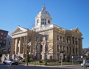
Marion County Courthouse in Fairmont
|
|||
|
|||

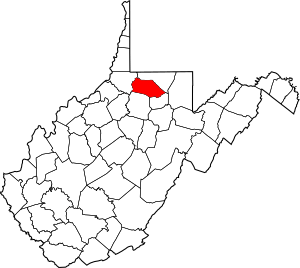
Location within the U.S. state of West Virginia
|
|||
 West Virginia's location within the U.S. |
|||
| Country | |||
| State | |||
| Founded | January 14, 1842 | ||
| Named for | Francis Marion | ||
| Seat | Fairmont | ||
| Largest city | Fairmont | ||
| Area | |||
| • Total | 312 sq mi (810 km2) | ||
| • Land | 309 sq mi (800 km2) | ||
| • Water | 2.8 sq mi (7 km2) 0.9%% | ||
| Population
(2020)
|
|||
| • Total | 56,205 | ||
| • Estimate
(2021)
|
56,001 |
||
| • Density | 180.14/sq mi (69.55/km2) | ||
| Time zone | UTC−5 (Eastern) | ||
| • Summer (DST) | UTC−4 (EDT) | ||
| Congressional district | 1st | ||
Marion County is a county in the state of West Virginia. In 2020, about 56,205 people lived here. Its main town, or county seat, is Fairmont. The county is named after General Francis Marion, a hero from the American Revolutionary War. He was known as "The Swamp Fox." Marion County is part of a larger area that includes Fairmont and Morgantown.
Contents
History of Marion County
Early People and Settlements
Long ago, groups of Native Americans like the Adena and Hopewell culture lived in this area. By the late 1700s, not many Native Americans lived here. This was partly because of wars, like the Beaver Wars, which caused many people to move away.
The first European settlers didn't arrive until 1772. They started building permanent homes along the Monongahela River and its smaller rivers.
How Marion County Was Formed
Marion County was officially created on January 14, 1842. The Virginia Assembly decided to take parts of Monongalia and Harrison Counties to form it. As mentioned, it was named after General Francis Marion, the famous "Swamp Fox" from the American Revolution.
Big Events in 1852
The year 1852 was very busy for Marion County.
- The Great Flood: On April 5, 1852, heavy rains caused the Monongahela River and West Fork River to flood. The water rose very quickly, reaching 43 feet above normal. Many houses and buildings were washed away, especially along the West Fork River.
- Railroad Arrives: Even with the flood damage, the Baltimore and Ohio Railroad was finished by June 23. This railroad connected Fairmont to cities in the east, like Baltimore. To cross the Monongahela River, a huge iron bridge was built. It was 650 feet long and 35 feet above the water.
- New Suspension Bridge: Also in 1852, the Fairmont and Palatine suspension bridge was completed. This bridge connected Fairmont to the town of Palatine. It cost about thirty thousand dollars to build.
Becoming Part of West Virginia
During the American Civil War, on June 20, 1863, Marion County became part of the new state of West Virginia. At first, the counties were divided into "townships" to help with local government. But this didn't work well in rural areas. So, in 1872, the townships became "magisterial districts." Marion County had seven districts: Fairmont, Grant, Lincoln, Mannington, Paw Paw, Union, and Winfield. Later, in the 1980s, these were combined into three new districts: Middletown, Palatine, and West Augusta.
Geography of Marion County
Marion County covers about 312 square miles. Most of this is land (309 square miles), and a small part (2.8 square miles) is water.
Main Roads
 Interstate 79
 U.S. Highway 19
 U.S. Highway 250
 West Virginia Route 218
 West Virginia Route 273
 West Virginia Route 310
Neighboring Counties
- Monongalia County (north)
- Taylor County (southeast)
- Harrison County (south)
- Wetzel County (west)
Population Information
| Historical population | |||
|---|---|---|---|
| Census | Pop. | %± | |
| 1850 | 10,552 | — | |
| 1860 | 12,722 | 20.6% | |
| 1870 | 12,107 | −4.8% | |
| 1880 | 17,198 | 42.1% | |
| 1890 | 20,721 | 20.5% | |
| 1900 | 32,430 | 56.5% | |
| 1910 | 42,794 | 32.0% | |
| 1920 | 54,571 | 27.5% | |
| 1930 | 66,655 | 22.1% | |
| 1940 | 68,683 | 3.0% | |
| 1950 | 71,521 | 4.1% | |
| 1960 | 63,717 | −10.9% | |
| 1970 | 61,356 | −3.7% | |
| 1980 | 65,789 | 7.2% | |
| 1990 | 57,249 | −13.0% | |
| 2000 | 56,598 | −1.1% | |
| 2010 | 56,418 | −0.3% | |
| 2020 | 56,205 | −0.4% | |
| 2021 (est.) | 56,001 | −0.7% | |
| U.S. Decennial Census 1790–1960 1900–1990 1990–2000 2010–2020 |
|||
2020 Census Details
In 2020, the census showed that 56,205 people lived in Marion County. Most residents (90%) were White. About 3.3% were African American, and 0.5% were Asian. People of Hispanic or Latino background made up 1.6% of the population. The average age in the county was 40.4 years old.
2010 Census Details
The census in 2010 counted 56,418 people living in the county. The population density was about 182.7 people per square mile. Most people (94.3%) were white. About 3.3% were black or African American. The average age was 41.0 years.
Communities in Marion County
Cities
- Fairmont (This is the county seat)
- Mannington
- Pleasant Valley
Towns
Magisterial Districts
- Middletown
- Palatine
- West Augusta
Census-Designated Places
These are areas that are like towns but are not officially incorporated.
Unincorporated Communities
These are smaller places without their own local government.
- Baxter
- Basnettville
- Beverly Hills
- Big Run
- Boothsville
- Brink
- Bunner Ridge
- Catawba
- Colfax
- Flyblow
- Forksburg
- Four States
- Grays Flat
- Hebron
- Highland
- Hopewell
- Hutchinson
- Joetown
- Jordan
- Katy
- Kingmont
- Logansport
- Meadowdale
- Metz
- Montana
- Montana Mines
- Paw Paw
- Pettyjohn
- Pine Grove
- Pleasant View
- Quiet Dell
- Shagtown
- Seven Pines
- Stringtown
- Viola
- Wahoo
- Watson
- Winfield
Famous People from Marion County
Many notable people have come from Marion County, including:
- David Carpenter, a baseball player.
- Frank Kendall Everest, Jr., known as The Fastest Man Alive.
- Frank Gatski, a football player in the Pro Football Hall of Fame.
- Sam Huff, a Pro Football Hall of Fame linebacker for the New York Giants and Washington Redskins.
- Johnnie Johnson, a talented musician.
- Joe Manchin, who used to be the governor of West Virginia and is now a United States senator.
- Mary Lou Retton, an Olympic gold medalist in gymnastics at the 1984 Olympic Games.
- Rich Rodriguez, a college football coach for teams like West Virginia and Michigan.
- Nick Saban, a very successful football coach for teams like LSU and Alabama.
- Hershel W. Williams, a Medal of Honor recipient for his bravery in World War II at the Battle of Iwo Jima.
- Tom Wilson, the creator of the comic strip Ziggy.
- Fielding H. Yost, a famous football coach for Michigan.
Marion County in Books
The fictional town of Grantville in the 1632 series of science fiction novels is based on the real town of Mannington in Marion County. In the books, this town is sent back in time to the 17th century by an alien event. The county and its places are often mentioned in the series. The author, Eric Flint, made sure that Grantville was very similar to Mannington in the year 2000.
See also
 In Spanish: Condado de Marion (Virginia Occidental) para niños
 | John T. Biggers |
 | Thomas Blackshear |
 | Mark Bradford |
 | Beverly Buchanan |


