Rivesville, West Virginia facts for kids
Quick facts for kids
Rivesville, West Virginia
|
|
|---|---|

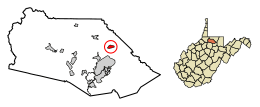
Location of Rivesville in Marion County, West Virginia.
|
|
| Country | United States |
| State | West Virginia |
| County | Marion |
| Area | |
| • Total | 0.59 sq mi (1.54 km2) |
| • Land | 0.52 sq mi (1.36 km2) |
| • Water | 0.07 sq mi (0.18 km2) |
| Elevation | 866 ft (264 m) |
| Population
(2020)
|
|
| • Total | 830 |
| • Estimate
(2021)
|
823 |
| • Density | 1,723.28/sq mi (664.98/km2) |
| Time zone | UTC-5 (Eastern (EST)) |
| • Summer (DST) | UTC-4 (EDT) |
| ZIP code |
26588
|
| Area code(s) | 304 |
| FIPS code | 54-68908 |
| GNIS feature ID | 1545784 |
Rivesville is a small town in Marion County, West Virginia, United States. It used to be a busy coal town. In 2020, about 830 people lived there.
Contents
Where is Rivesville Located?
Rivesville is found at 39°31′49″N 80°7′9″W / 39.53028°N 80.11917°W. It sits on the northwest bank of the Monongahela River. This is where the Paw Paw Creek joins the river. The town is in the middle of the Fairmont area, which is known for its coal.
The town covers about 0.59 square miles (1.54 square kilometers). Most of this area is land, with a small part being water.
How Many People Live in Rivesville?
| Historical population | |||
|---|---|---|---|
| Census | Pop. | %± | |
| 1860 | 54 | — | |
| 1870 | 63 | 16.7% | |
| 1880 | 136 | 115.9% | |
| 1890 | 165 | 21.3% | |
| 1900 | 164 | −0.6% | |
| 1910 | 190 | 15.9% | |
| 1920 | 1,061 | 458.4% | |
| 1930 | 1,700 | 60.2% | |
| 1940 | 1,552 | −8.7% | |
| 1950 | 1,343 | −13.5% | |
| 1960 | 1,191 | −11.3% | |
| 1970 | 1,108 | −7.0% | |
| 1980 | 1,327 | 19.8% | |
| 1990 | 1,064 | −19.8% | |
| 2000 | 913 | −14.2% | |
| 2010 | 934 | 2.3% | |
| 2020 | 830 | −11.1% | |
| 2021 (est.) | 823 | −11.9% | |
| U.S. Decennial Census | |||
In 2010, there were 934 people living in Rivesville. Most residents were White (98.7%). A small number were African American or Native American. About 0.3% of the population was Hispanic or Latino.
The town had 402 households. Many of these (29.1%) had children under 18 living there. The average age of people in Rivesville was about 42 years old.
A Look at Rivesville's Past
Rivesville has a long history, with some of the first settlers arriving here early on.
Early Settlers and Prickett's Fort
One of the first settlers was David Morgan (frontiersman), who moved to the area in 1772. Across the Monongahela River was Prickett's Fort. This fort offered safety to settlers from attacks. In 1778, David Morgan famously saved his family from an attack by Native Americans. He had a dream about the attack while he was recovering at the fort.
The house where this event happened still stands in Rivesville today. It is called the Morgan-Gold House and was added to the National Register of Historic Places in 1985.
How Rivesville Got Its Name
The town of Rivesville was officially planned out in 1837. It was named after William Cabell Rives.
Growth of the Town and Coal Mining
In 1900, Rivesville was very small, with only 164 people. By 1910, the population had grown slightly to 190. However, after this, large-scale coal mining began in the area. This led to a big increase in the town's population.
Railroads and Transportation
In the early 1900s, Rivesville was an important spot for railroads. It was where the Pawpaw branch of the B&O Railroad met another line. This other line later became part of the Monongahela Railway in 1915.
Rivesville also had an electric train line called an interurban. This line ran from Fairmont through Rivesville to the Rivesville Power Station.
Important Places in Rivesville
Local Schools
The Rivesville Elementary/Middle School teaches students from kindergarten to 8th grade. It used to be Rivesville High School. The school works with West Virginia University to help train new teachers. In 2007, the school had 338 students.
The Rivesville Power Plant
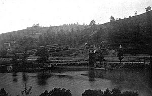
The Rivesville Power Plant was built in 1919. It used to be run by Monongahela Power and Railway Company and later by Allegheny Energy. This plant generated electricity using coal.
The plant used to draw a lot of water from the Monongahela River to cool its systems. Coal was brought to the plant by barges and sometimes by trains. In the 1970s, this plant was one of the first to use a new way to burn coal called fluidized bed combustion.
In 2012, the power plant had to close down. This was because of new rules to protect the environment.
Coal Mining in the Area
Rivesville was a major center for coal mining. Most of the coal around Rivesville has been mined out, except for the areas directly under the older part of town and under the river.
Consolidation Coal Company Mines
One important mine was Consolidation Coal Company Mine No. 97. It was in the Pittsburgh coal seam, about 100 feet below the river. This mine operated from 1922 to 1954. At its busiest, it produced over 670,000 tons of coal each year. The coal layer itself was 6 to 8 feet thick.
Another mine, Consol. Mine No. 24, was across the river. In 1943, there were plans to connect these two mines under the river. In 1934, Mine No. 97 employed 412 men, all of whom were members of the UMWA union.
Other Coal Mines
Other mines in the area dug for coal closer to the surface. For example, the Parker Run Coal and Coke Company operated a mine near Rivesville between 1901 and 1913. This mine shipped coal by train and barge. In 1910, it employed 60 miners.
Other companies also had mines in the Rivesville area, including the Rivesville Coal Company and the Winfield Coal Company.
Famous People from Rivesville
- Harrison C. Summers, a hero from WWII.
See also
 In Spanish: Rivesville (Virginia Occidental) para niños
 | Precious Adams |
 | Lauren Anderson |
 | Janet Collins |


