Mannington, West Virginia facts for kids
Quick facts for kids
Mannington, West Virginia
|
|
|---|---|

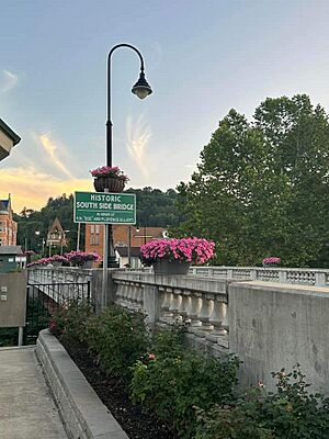
Mannington Historic District, September 2023
|
|

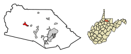
Location of Mannington in Marion County, West Virginia.
|
|
| Country | United States |
| State | West Virginia |
| County | Marion |
| Area | |
| • Total | 1.14 sq mi (2.95 km2) |
| • Land | 1.09 sq mi (2.83 km2) |
| • Water | 0.05 sq mi (0.12 km2) |
| Elevation | 974 ft (297 m) |
| Population
(2020)
|
|
| • Total | 1,961 |
| • Estimate
(2021)
|
1,946 |
| • Density | 1,850.87/sq mi (714.74/km2) |
| Time zone | UTC-5 (Eastern (EST)) |
| • Summer (DST) | UTC-4 (EDT) |
| ZIP code |
26582
|
| Area code(s) | 304/681 |
| FIPS code | 54-51100 |
| GNIS feature ID | 1542721 |
Mannington is a city found in Marion County, West Virginia, in the United States. It's nestled among the hills of North Central West Virginia. In 2020, about 1,961 people lived there. Long ago, it was known as Forks of Buffalo or Koon Town. But since 1856, it has been called Mannington.
Contents
Mannington's Past
Early Days of Settlement
When the first settlers arrived, the west part of Buffalo Creek was called Warrior's Fork. The North Fork was known as Pyle's Fork. One of the first people to settle here was John Ice. His family had a tough experience when his mother, two sisters, and brother were captured by Native Americans. His mother was never found, but his brother, "Indian Billy," returned. His sisters chose to stay with their captors.
James Madison, who later became a U.S. president, bought some land nearby. This was an investment for him.
Most of the land where Mannington now stands was owned by Robert Rutherford. He helped fund the American Revolutionary War and was a friend of George Washington. In 1799, Rutherford sold his land to James Brown. After some money problems, Brown sold the land in 1824 to a group of investors from Baltimore, Maryland.
One of these investors, William Baker, eventually bought out his partners. Then, in 1840, he sold the land to James Hanway, a surveyor. Hanway divided the land into smaller pieces and started selling them. This is how Mannington began to grow.
From Forks of Buffalo to Mannington
After the land was divided, more people became interested in the area. The population grew, and log houses were built. Soon, businesses started to appear. By 1850, George and Samuel Koon opened a tavern. Because of this tavern, the area became known as Koon Town.
However, the U.S. government still called its first post office here the Forks of Buffalo Post Office. It wasn't until 1856 that the village officially became Mannington. It was named after Charles Manning, a civil engineer for the Baltimore and Ohio (B&O) Railroad. People liked Manning, and they wanted a more "dignified" name for their growing town along the new railroad line.
The arrival of the railroad brought bigger industries to Mannington. Logging (cutting down trees) and coal became important. Other businesses also started up. Tree bark was used by tanneries to make leather goods. New mills for wood and lumber were built. The railroad also made it easier to transport cattle, sheep, and crops.
During the American Civil War, the B&O railroad was very important to both sides. It suffered more damage than Mannington itself. Even though some railroad bridges were burned by Confederate forces, the Union army protected the Mannington section of the line.
Oil and Gas Boom
A new and exciting time for Mannington began in 1889. This was when the first oil drilling started. Dr. Israel C. White, a famous geologist, suggested drilling here. Many people thought there wasn't much oil, but White kept going. He soon got enough local support to drill.
When oil was first found in late 1889, land prices doubled in just two days! The Mannington oil field became one of the biggest in West Virginia. The largest well produced about 1,600 barrels of oil each day.
Dr. White also encouraged looking for natural gas. This was even more successful than the oil. It caused Mannington to grow a lot. The population went from about 700 people in the late 1800s to over 4,000 by 1917.
By 1900, Mannington was a busy town. It had its own trolley system, electricity, theaters, schools, and telephones. The Mannington School Building, built in 1902–1903, was a source of pride for the town. In 1923, Albert Heck started the first community radio cable system here.
From Boom to Bust
The stock market crash in 1929 and the Great Depression hit Mannington's economy hard. The trolley stopped running in 1933. Factory workers lost their jobs as people bought fewer products. The town's population began to shrink.
Mannington's Location and Climate
Where is Mannington?
Mannington is located at 39°31′38″N 80°20′23″W / 39.52722°N 80.33972°W. It sits along Buffalo Creek.
The United States Census Bureau says the city covers about 1.15 square miles (2.95 square kilometers). Most of this area is land, with a small part being water.
What's the Weather Like?
Mannington has a climate with fairly high temperatures and rain spread out evenly through the year. This type of weather is called a Humid subtropical climate.
| Climate data for Mannington, West Virginia (1991–2020 normals, extremes 1980–present) | |||||||||||||
|---|---|---|---|---|---|---|---|---|---|---|---|---|---|
| Month | Jan | Feb | Mar | Apr | May | Jun | Jul | Aug | Sep | Oct | Nov | Dec | Year |
| Record high °F (°C) | 75 (24) |
80 (27) |
88 (31) |
93 (34) |
94 (34) |
97 (36) |
103 (39) |
100 (38) |
98 (37) |
93 (34) |
82 (28) |
75 (24) |
103 (39) |
| Mean daily maximum °F (°C) | 38.3 (3.5) |
42.1 (5.6) |
52.4 (11.3) |
65.7 (18.7) |
74.1 (23.4) |
80.9 (27.2) |
84.1 (28.9) |
83.1 (28.4) |
77.1 (25.1) |
65.7 (18.7) |
52.8 (11.6) |
42.5 (5.8) |
63.2 (17.3) |
| Daily mean °F (°C) | 28.5 (−1.9) |
31.2 (−0.4) |
39.7 (4.3) |
51.0 (10.6) |
60.4 (15.8) |
68.1 (20.1) |
72.1 (22.3) |
70.7 (21.5) |
63.8 (17.7) |
52.2 (11.2) |
41.1 (5.1) |
33.2 (0.7) |
51.0 (10.6) |
| Mean daily minimum °F (°C) | 18.7 (−7.4) |
20.3 (−6.5) |
27.1 (−2.7) |
36.2 (2.3) |
46.7 (8.2) |
53.3 (11.8) |
60.0 (15.6) |
58.3 (14.6) |
50.5 (10.3) |
38.7 (3.7) |
29.4 (−1.4) |
23.9 (−4.5) |
38.8 (3.8) |
| Record low °F (°C) | −34 (−37) |
−21 (−29) |
−13 (−25) |
12 (−11) |
25 (−4) |
25 (−4) |
32 (0) |
34 (1) |
22 (−6) |
14 (−10) |
4 (−16) |
−24 (−31) |
−34 (−37) |
| Average precipitation inches (mm) | 4.41 (112) |
3.99 (101) |
4.36 (111) |
4.32 (110) |
4.92 (125) |
4.44 (113) |
5.64 (143) |
4.10 (104) |
4.17 (106) |
3.37 (86) |
3.57 (91) |
4.15 (105) |
51.44 (1,307) |
| Average precipitation days (≥ 0.01 in) | 18.2 | 15.9 | 14.1 | 15.4 | 15.1 | 13.1 | 12.6 | 10.9 | 10.5 | 10.7 | 12.7 | 16.7 | 165.9 |
| Source: NOAA | |||||||||||||
People of Mannington
| Historical population | |||
|---|---|---|---|
| Census | Pop. | %± | |
| 1860 | 241 | — | |
| 1870 | 411 | 70.5% | |
| 1890 | 908 | — | |
| 1900 | 1,681 | 85.1% | |
| 1910 | 2,672 | 59.0% | |
| 1920 | 3,673 | 37.5% | |
| 1930 | 3,261 | −11.2% | |
| 1940 | 3,145 | −3.6% | |
| 1950 | 3,241 | 3.1% | |
| 1960 | 2,996 | −7.6% | |
| 1970 | 2,747 | −8.3% | |
| 1980 | 3,036 | 10.5% | |
| 1990 | 2,184 | −28.1% | |
| 2000 | 2,124 | −2.7% | |
| 2010 | 2,063 | −2.9% | |
| 2020 | 1,961 | −4.9% | |
| 2021 (est.) | 1,946 | −5.7% | |
| U.S. Decennial Census | |||
Population in 2010
According to the census from 2010, there were 2,063 people living in Mannington. These people made up 842 households and 578 families. The city had about 1,875 people per square mile.
Most of the people living in Mannington were White (98.8%). A small number were African American, Native American, or Asian. About 0.9% of the population was Hispanic or Latino.
The average age in the city was 41.8 years old. About 23.5% of residents were under 18. About 17.5% were 65 years old or older. Slightly more than half of the residents were female (52.2%).
City Roads
See also
 In Spanish: Mannington (Virginia Occidental) para niños
 | John T. Biggers |
 | Thomas Blackshear |
 | Mark Bradford |
 | Beverly Buchanan |

