
Harrison County, West Virginia facts for kids
Quick facts for kids
Harrison County
|
||
|---|---|---|

Harrison County Courthouse
|
||
|
||

Location within the U.S. state of West Virginia
|
||
 West Virginia's location within the U.S. |
||
| Country | ||
| State | ||
| Founded | May 3, 1784 | |
| Named for | Benjamin Harrison V | |
| Seat | Clarksburg | |
| Largest city | Clarksburg | |
| Area | ||
| • Total | 417 sq mi (1,080 km2) | |
| • Land | 416 sq mi (1,080 km2) | |
| • Water | 0.5 sq mi (1 km2) 0.1%% | |
| Population
(2020)
|
||
| • Estimate
(2021)
|
65,158 |
|
| Time zone | UTC−5 (Eastern) | |
| • Summer (DST) | UTC−4 (EDT) | |
| Congressional district | 1st | |

Harrison County is a special area in the U.S. state of West Virginia. It's like a big neighborhood with its own local government. In 2020, about 65,921 people lived here. The main town, or county seat, is Clarksburg. Harrison County is part of the larger Clarksburg area.
Contents
Exploring Harrison County's Past
Long ago, thousands of years before European settlers arrived, Native American people lived in the area that is now Harrison County. The Hopewell culture, known for building large earth mounds, created the Oak Mounds near Clarksburg around 1,000 to 2,000 years ago. These mounds are important historical sites.
Early Settlers and County Beginnings
White trappers first visited this area in the 1760s. They sometimes traded with the Native Americans. The land was then part of the Virginia Colony.
The first person to settle permanently was John Simpson. He built a cabin in 1763 or 1764 near the West Fork River. A creek in the area, "Simpson's Creek", is named after him. Another settler, Daniel Davisson, claimed the land where Clarksburg is today in 1773.
Harrison County was officially created in 1784. It was formed from a larger area called Monongalia County. The county was named after Benjamin Harrison V, who was a governor of Virginia. He was also the father of William Henry Harrison, who became the 9th President of the United States.
The first meeting for Harrison County's court was held on July 20, 1784. They chose Clarksburg as the county seat. The town was named after a famous explorer, General George Rogers Clark. Clarksburg became an official town in 1785 and was incorporated in 1795.
Growth in the 1800s

Clarksburg got its first newspaper, The By-Stander, in 1810. In 1836, the Northwestern Turnpike road reached the town. This road connected Clarksburg to other important places like Winchester and Parkersburg, which helped the town grow.
The arrival of the Baltimore and Ohio Railroad in 1856 was also a big deal. The railroad helped the local coal mining industry develop a lot in the late 1800s and early 1900s.
In 1863, after West Virginia became a state, counties were divided into smaller areas called townships. This was meant to help local government. However, it didn't work well in rural areas. So, in 1872, these townships became "magisterial districts." Harrison County first had ten districts. Over time, these districts changed. By the 1990s, they were organized into six main districts: Eastern, Northern, North Urban, Southern, South Urban, and Southwest.
Geography and Nature
Harrison County has rolling hills, many covered with trees. Rivers and creeks flow through the land. The West Fork River flows north through the county, with smaller creeks like Tenmile Creek, Simpson Creek, and Elk Creek joining it.
The county covers about 417 square miles. Most of this is land, with a small amount of water. The highest point in the county is about 1,736 feet above sea level.
Main Roads and Travel
 Interstate 79
 U.S. Route 19
 U.S. Route 50
 West Virginia Route 20
 West Virginia Route 23
 West Virginia Route 57
 West Virginia Route 58
 West Virginia Route 76
 West Virginia Route 98
 West Virginia Route 131
 West Virginia Route 270
 West Virginia Route 279
Airports in Harrison County

- North Central West Virginia Airport is located northeast of Bridgeport.
- Wade F. Maley Field is northeast of Shinnston.
Neighboring Counties
- Marion County - north
- Taylor County - east
- Barbour County - southeast
- Upshur County - south
- Lewis County - southwest
- Doddridge County - west
- Wetzel County - northwest
Parks and Lakes
Harrison County is home to Watters Smith State Park, a great place to explore nature. There are also several lakes, including Deegan Lake, Lake Floyd, Maple Lake, Mine 95 Water Supply Reservoir, Oral Lake, and Salem Auxiliary Lake.
People and Population
| Historical population | |||
|---|---|---|---|
| Census | Pop. | %± | |
| 1790 | 2,080 | — | |
| 1800 | 4,848 | 133.1% | |
| 1810 | 9,958 | 105.4% | |
| 1820 | 10,932 | 9.8% | |
| 1830 | 14,722 | 34.7% | |
| 1840 | 17,669 | 20.0% | |
| 1850 | 11,728 | −33.6% | |
| 1860 | 13,790 | 17.6% | |
| 1870 | 16,714 | 21.2% | |
| 1880 | 20,181 | 20.7% | |
| 1890 | 21,919 | 8.6% | |
| 1900 | 27,690 | 26.3% | |
| 1910 | 48,381 | 74.7% | |
| 1920 | 74,793 | 54.6% | |
| 1930 | 78,567 | 5.0% | |
| 1940 | 82,911 | 5.5% | |
| 1950 | 85,296 | 2.9% | |
| 1960 | 77,856 | −8.7% | |
| 1970 | 73,028 | −6.2% | |
| 1980 | 77,710 | 6.4% | |
| 1990 | 69,371 | −10.7% | |
| 2000 | 68,652 | −1.0% | |
| 2010 | 69,099 | 0.7% | |
| 2020 | 65,921 | −4.6% | |
| 2021 (est.) | 65,158 | −5.7% | |
| US Decennial Census 1790–1960 1900–1990 1990–2000 2010–2020 |
|||
The population of Harrison County has changed a lot over the years. In 1790, there were just over 2,000 people. By 1950, the population grew to over 85,000. In 2020, the population was 65,921.
Who Lives in Harrison County?
In 2020, most people in Harrison County were White (91.5%). There were also African American (1.7%), Asian (0.7%), and Native American (0.2%) residents. About 5.2% of people identified with two or more races. People of Hispanic or Latino origin made up 2.1% of the population.
The average age in the county was 42.4 years. The average income for a household was about $51,553.
Towns and Communities

Harrison County has several cities and towns where people live and work.
Cities in Harrison County
- Bridgeport
- Clarksburg (the county seat)
- Salem
- Shinnston
- Stonewood
Towns in Harrison County
Magisterial Districts
These are the local government areas within the county:
- Eastern
- Northern
- North Urban
- Southern
- South Urban
- Southwest
Census-Designated Places
These are areas that are like towns but are not officially incorporated as cities or towns:
- Despard
- East View
- Enterprise
- Gypsy
- Hepzibah
- Reynoldsville
- Spelter
- Wallace
- Wolf Summit
Charles Pointe: A Growing Community
Harrison County is home to Charles Pointe, a large planned community being built in Bridgeport. It will have homes, shops, and places for fun, covering about 1,700 acres. Nearby is the United Hospital Center, a modern medical facility. There's also White Oaks, a business community that supports the hospital and the FBI's CJIS complex. This area along Interstate 79 is sometimes called a "High Tech Corridor" because of the many technology-related businesses.
Important Historical Places

Harrison County has several places listed on the National Register of Historic Places. These sites are important because they tell us about the past.
- Fletcher Covered Bridge
- Kelly Miller High School
- Oak Mounds
- Simpson Creek Covered Bridge
- The Waldomore
Famous People from Harrison County
Many notable people have come from Harrison County:
- John S. Carlile: A senator from Virginia during the Civil War.
- John W. Davis: A candidate for President of the United States in 1924.
- Guy Goff: A United States Senator.
- Joseph Johnson: The 32nd Governor of Virginia.
- Jennings Randolph: A U.S. Representative and later a U.S. Senator for many years.
- Cyrus Vance: Served as U.S. Secretary of State, Deputy Secretary of Defense, and Secretary of the Army.
Images for kids
-
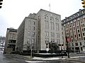
Harrison County Courthouse
-
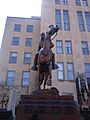
Statue of Civil War Confederate General Thomas J. "Stonewall" Jackson, in front of the Harrison County Courthouse
-

Left, the West Virginia Black Heritage Festival in Clarksburg, WV. Center, the Scottish Festival & Celtic Gathering in Bridgeport, WV. Right, the West Virginia Italian Heritage Festival in Clarksburg.
-
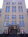
Harrison County Courthouse
-
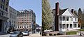
Views of Main Street in Clarksburg (left) and the Benedum Civic Center in Bridgeport (right). Clarksburg and Bridgeport are the largest cities in Harrison County.
See also
 In Spanish: Condado de Harrison (Virginia Occidental) para niños
