Nutter Fort, West Virginia facts for kids
Quick facts for kids
Nutter Fort, West Virginia
|
||
|---|---|---|
|
||
| Motto(s):
Progress With a Small Town Atmosphere
|
||

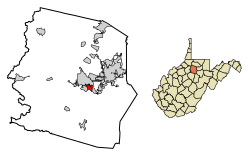
Location of Nutter Fort in Harrison County, West Virginia.
|
||
| Country | United States | |
| State | West Virginia | |
| County | Harrison | |
| Area | ||
| • Total | 6.89 sq mi (2.30 km2) | |
| • Land | 6.89 sq mi (2.30 km2) | |
| • Water | 0.00 sq mi (0.00 km2) | |
| Elevation | 1,056 ft (322 m) | |
| Population
(2020)
|
||
| • Total | 1,497 | |
| • Estimate
(2021)
|
1,478 | |
| • Density | 1,700.79/sq mi (656.40/km2) | |
| Time zone | UTC-5 (Eastern (EST)) | |
| • Summer (DST) | UTC-4 (EDT) | |
| ZIP code |
26301
|
|
| Area code(s) | 304 | |
| FIPS code | 54-59836 | |
| GNIS feature ID | 1555248 | |
Nutter Fort is a town in Harrison County, West Virginia, United States. It became an official town in 1923. Nutter Fort is located southeast of Clarksburg, acting like a close neighbor or suburb to the larger city.
Contents
The Story of Nutter Fort
Nutter Fort has a cool history that goes back to the 1770s. Four brothers named Thomas, Matthew, John, and Christopher Nutter received a large piece of land near Elk Creek. They wanted a safe place because there were conflicts with Native Americans.
In 1772, with the help of other settlers, they built a strong fort. This fort, later called Nutter's Fort, was a safe spot for families when there were raids. Today, the original fort is gone, but its foundation still remains.
West Virginia Blackberry Festival
From 1996 to 2019, Nutter Fort hosted the West Virginia Blackberry Festival every year. This festival celebrated the area's farming history and helped protect important old buildings, like the Roosevelt-Wilson High School. The festival was canceled in 2020 because of COVID-19. In 2022, the mayor announced that the festival would not be coming back.
Where is Nutter Fort?
Nutter Fort is located at 39.262163 degrees north latitude and -80.322389 degrees west longitude, right along Elk Creek.
The United States Census Bureau says that Nutter Fort covers about 0.85 square miles (2.30 square kilometers) of land. There is no water area within the town limits.
Who Lives in Nutter Fort?
| Historical population | |||
|---|---|---|---|
| Census | Pop. | %± | |
| 1930 | 1,825 | — | |
| 1940 | 1,803 | −1.2% | |
| 1950 | 2,285 | 26.7% | |
| 1960 | 2,440 | 6.8% | |
| 1970 | 2,379 | −2.5% | |
| 1980 | 2,078 | −12.7% | |
| 1990 | 1,819 | −12.5% | |
| 2000 | 1,686 | −7.3% | |
| 2010 | 1,593 | −5.5% | |
| 2020 | 1,497 | −6.0% | |
| 2021 (est.) | 1,478 | −7.2% | |
| U.S. Decennial Census | |||
Nutter Fort's Population in 2010
According to the census taken in 2010, 1,593 people lived in Nutter Fort. These people lived in 743 households, and 436 of those were families. The town had about 1,874 people per square mile.
There were 826 housing units in the town. Most of the people living in Nutter Fort were White (96.4%). A small number were African American (0.8%), Native American (0.2%), or Asian (0.5%). About 1.3% of the population identified as Hispanic or Latino.
About 25.8% of households had children under 18 living there. Around 39.0% of households were married couples. About 15.7% of households had someone living alone who was 65 years old or older. The average household had 2.13 people.
The average age of people in Nutter Fort was 41.8 years old. About 19.1% of residents were under 18. About 19.3% were 65 years old or older. The town had slightly more females (52.5%) than males (47.5%).
Getting Around Nutter Fort
Two main roads help people travel through Nutter Fort:
See also
 In Spanish: Nutter Fort (Virginia Occidental) para niños
 | Delilah Pierce |
 | Gordon Parks |
 | Augusta Savage |
 | Charles Ethan Porter |


