Upshur County, West Virginia facts for kids
Quick facts for kids
Upshur County
|
||
|---|---|---|

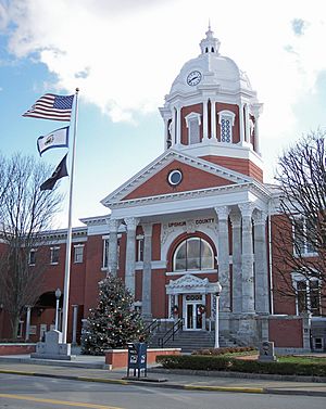
The Upshur County Courthouse, designed by architect Harrison Albright pictured in Buckhannon in 2006
|
||
|
||

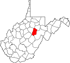
Location within the U.S. state of West Virginia
|
||
 West Virginia's location within the U.S. |
||
| Country | ||
| State | ||
| Founded | March 26, 1851 | |
| Named for | Abel Parker Upshur | |
| Seat | Buckhannon | |
| Largest city | Buckhannon | |
| Area | ||
| • Total | 355 sq mi (920 km2) | |
| • Land | 355 sq mi (920 km2) | |
| • Water | 0.1 sq mi (0.3 km2) 0.03%% | |
| Population
(2020)
|
||
| • Total | 23,816 | |
| • Estimate
(2021)
|
23,791 |
|
| • Density | 67.09/sq mi (25.90/km2) | |
| Time zone | UTC−5 (Eastern) | |
| • Summer (DST) | UTC−4 (EDT) | |
| Congressional district | 2nd | |
Upshur County is a place in West Virginia, a state in the United States. In 2020, about 23,816 people lived there. Its main town, called the county seat, is Buckhannon. The county was created in 1851 from parts of Randolph, Barbour, and Lewis counties. It was named after Abel Parker Upshur. He was an important leader and judge from Virginia. Upshur also worked for the US government as the Secretary of State and Secretary of the Navy. He served under President John Tyler.
Contents
Exploring Upshur County's Geography
Upshur County covers about 355 square miles. Most of this area is land. Only a tiny part, about 0.1 square miles, is water. The county is part of a special area called the United States National Radio Quiet Zone. This means there are rules about radio signals here. The highest point in Upshur County is 3,160 feet high. It is located near Sugar Run, close to the border with Randolph County.
How Upshur County is Divided
In 1863, West Virginia counties were split into smaller areas called townships. This was done to help local governments. But it was hard to manage in rural areas. So, in 1872, these townships became "magisterial districts." Upshur County first had six districts: Banks, Buckhannon, Meade, Union, Warren, and Washington. In the 1990s, these six districts were changed. They became three new districts: First, Second, and Third.
Main Roads in Upshur County
These are the most important roads that go through Upshur County:
Neighboring Counties
Upshur County shares its borders with these other counties:
- Harrison County to the north
- Barbour County to the northeast
- Randolph County to the southeast
- Webster County to the south
- Lewis County to the west
People and Population in Upshur County
| Historical population | |||
|---|---|---|---|
| Census | Pop. | %± | |
| 1860 | 7,292 | — | |
| 1870 | 8,023 | 10.0% | |
| 1880 | 10,249 | 27.7% | |
| 1890 | 12,714 | 24.1% | |
| 1900 | 14,696 | 15.6% | |
| 1910 | 16,629 | 13.2% | |
| 1920 | 17,851 | 7.3% | |
| 1930 | 17,944 | 0.5% | |
| 1940 | 18,360 | 2.3% | |
| 1950 | 19,242 | 4.8% | |
| 1960 | 18,292 | −4.9% | |
| 1970 | 19,092 | 4.4% | |
| 1980 | 23,427 | 22.7% | |
| 1990 | 22,867 | −2.4% | |
| 2000 | 23,404 | 2.3% | |
| 2010 | 24,254 | 3.6% | |
| 2020 | 23,816 | −1.8% | |
| 2021 (est.) | 23,791 | −1.9% | |
| U.S. Decennial Census 1790–1960 1900–1990 1990–2000 2010–2020 |
|||
The number of people living in Upshur County has changed over many years. You can see how the population has grown and shrunk in the chart above.
Population in 2020
In 2020, about 23,816 people lived in Upshur County. There were 9,599 households, which are groups of people living together. Most people, about 94.4%, were White. About 0.9% were African American, and 0.7% were Asian. People of Hispanic or Latino background made up about 1.3% of the population. The average age of people in the county was 41.9 years old. About 20.8% of the people were under 18 years old. The average income for a household was $44,470.
Population in 2010
In 2010, there were 24,254 people living in Upshur County. There were 9,619 households. Most people, about 97.6%, were White. About 1% of the population was of Hispanic or Latino origin. The average age was 40.9 years. The average income for a household was $36,114. About 19.3% of the people were living below the poverty line.
Communities in Upshur County
City
- Buckhannon (This is the county seat, the main town)
Magisterial Districts
Current Districts
- First
- Second
- Third
Historic Districts
Upshur County was first divided into six townships in 1863. These were later replaced in the 1990s.
- Banks District, named after Nathaniel Prentiss Banks
- Buckhannon District, named after the county's main town
- Meade District, named after General George Gordon Meade
- Union District, named for soldiers who fought for the Union
- Warren District, named after Gouverneur Kemble Warren
- Washington District, named after President George Washington
Small Towns and Areas (Unincorporated Communities)
- Abbott
- Adrian
- Alexander
- Alton
- Arlington
- Atlas
- Beans Mill
- Canaan
- Carter
- Craddock
- Daysville
- Deanville
- Eden
- Ellamore
- Evergreen
- Excelsior
- Five Forks
- Freeman
- French Creek
- Frenchton
- Gaines
- Gale
- Goodwin
- Gormley
- Goshen
- Gould
- Hampton
- Heavener Grove
- Hemlock
- Hinkleville
- Hodgesville
- Holly Grove
- Hoover Town
- Imperial
- Ingo
- Ivy
- Kanawha Head
- Kedron
- Kesling Mill
- Lorentz
- McCuetown
- Midvale
- Nebo
- Newlonton
- Overhill
- Palace Valley
- Post Mill
- Queens
- Red Rock
- Reger
- Rock Cave
- Rocky Ford
- Ruraldale
- Sago
- Sand Run
- Selbyville
- Shahan
- South Buckhannon
- Swamp Run
- Tallmansville
- Tenmile
- Tennerton
- Teter
- Vegan
- White Oak
- Wilsontown
- Yokum
- Zion
Upshur County's Economy
The economy in Upshur County includes several important activities. These are coal mining and timber (cutting down trees for wood). Higher education is also a big part of the economy. The main town, Buckhannon, is home to West Virginia Wesleyan College. This is a small, private college. The West Virginia State Wildlife Center in French Creek also brings in money. It is a popular place for tourists to visit. Upshur County also has coal mines, like the Sago Mine.
See also
 In Spanish: Condado de Upshur (Virginia Occidental) para niños
 | George Robert Carruthers |
 | Patricia Bath |
 | Jan Ernst Matzeliger |
 | Alexander Miles |


