
Lewis County, West Virginia facts for kids
Quick facts for kids
Lewis County
|
||
|---|---|---|

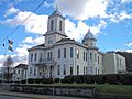
Lewis County Courthouse
|
||
|
||

Location within the U.S. state of West Virginia
|
||
 West Virginia's location within the U.S. |
||
| Country | ||
| State | ||
| Founded | December 18, 1816 | |
| Seat | Weston | |
| Largest city | Weston | |
| Area | ||
| • Total | 390 sq mi (1,000 km2) | |
| • Land | 385 sq mi (1,000 km2) | |
| • Water | 4.8 sq mi (12 km2) 1.2%% | |
| Population
(2020)
|
||
| • Total | 17,033 | |
| • Estimate
(2021)
|
16,892 |
|
| • Density | 43.7/sq mi (16.86/km2) | |
| Time zone | UTC−5 (Eastern) | |
| • Summer (DST) | UTC−4 (EDT) | |
| Congressional district | 2nd | |

Lewis County is a cool place located in the state of West Virginia, USA. In 2020, about 17,033 people lived here. Its main town, or county seat, is Weston. The county was created in 1816 from part of Harrison County. It was named after Colonel Charles Lewis, a brave Virginian who died in the Battle of Point Pleasant.
Contents
Lewis County Geography
Lewis County covers a total area of about 390 square miles. Most of this area, 385 square miles, is land. The remaining 4.8 square miles, which is about 1.2%, is water.
Main Roads and Highways
These are the important roads that help people travel through Lewis County:
 Interstate 79
 U.S. Highway 19
 U.S. Highway 48
 U.S. Highway 33/119
 West Virginia Route 4
Neighboring Counties
Lewis County shares borders with these other counties:
- Harrison County (to the north)
- Upshur County (to the east)
- Webster County (to the south)
- Braxton County (to the southwest)
- Gilmer County (to the west)
- Doddridge County (to the northwest)
Lewis County Population
| Historical population | |||
|---|---|---|---|
| Census | Pop. | %± | |
| 1820 | 4,247 | — | |
| 1830 | 6,241 | 47.0% | |
| 1840 | 8,151 | 30.6% | |
| 1850 | 10,031 | 23.1% | |
| 1860 | 7,999 | −20.3% | |
| 1870 | 10,175 | 27.2% | |
| 1880 | 13,269 | 30.4% | |
| 1890 | 15,895 | 19.8% | |
| 1900 | 16,980 | 6.8% | |
| 1910 | 18,821 | 10.8% | |
| 1920 | 20,455 | 8.7% | |
| 1930 | 21,794 | 6.5% | |
| 1940 | 22,271 | 2.2% | |
| 1950 | 21,074 | −5.4% | |
| 1960 | 19,711 | −6.5% | |
| 1970 | 17,847 | −9.5% | |
| 1980 | 18,813 | 5.4% | |
| 1990 | 17,223 | −8.5% | |
| 2000 | 16,919 | −1.8% | |
| 2010 | 16,372 | −3.2% | |
| 2020 | 17,033 | 4.0% | |
| 2021 (est.) | 16,892 | 3.2% | |
| U.S. Decennial Census 1790–1960 1900–1990 1990–2000 2010–2020 |
|||
2020 Census Facts
In 2020, the census showed that 17,033 people lived in Lewis County. There were 6,662 households. Most people, about 94.5%, were White. About 1.1% of the population was of Hispanic or Latino background. The average age of people in the county was 43.6 years. About 21.2% of the population was under 18 years old.
Communities in Lewis County
Lewis County has different types of communities where people live.
Cities and Towns
Local Districts
Lewis County is divided into special areas called magisterial districts. These help with local government.
- Courthouse-Collins Settlement
- Freemans Creek
- Hackers Creek-Skin Creek
Small Unincorporated Communities
These are smaller places that are not officially cities or towns.
- Aberdeen
- Alkires Mills
- Alum Bridge
- Arnold
- Aspinall
- Bablin
- Bealls Mills
- Ben Dale
- Bennett
- Berlin
- Brownsville
- Butchersville
- Camden
- Churchville
- Copley
- Cox Town
- Crawford
- Emmart
- Freemansburg
- Gaston
- Georgetown
- Homewood
- Horner
- Ireland
- Jackson Mill
- Jacksonville
- Kitsonville
- Lightburn
- McGuire Park
- Orlando
- Pickle Street
- Roanoke
- Turnertown
- Walkersville
- Valley Chapel
- Vadis
Images for kids
-
Lewis County Courthouse
See also
 In Spanish: Condado de Lewis (Virginia Occidental) para niños
