Bridgeport, West Virginia facts for kids
Quick facts for kids
Bridgeport, West Virginia
|
||
|---|---|---|

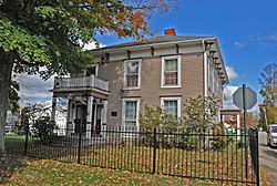
Governor Joseph Johnson House
|
||
|
||
| Motto(s):
Opportunity Lives Here
|
||

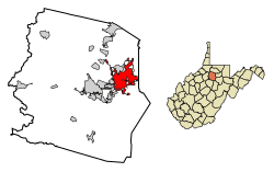
Location of Bridgeport in Harrison County, West Virginia.
|
||
| Country | United States | |
| State | West Virginia | |
| County | Harrison | |
| Government | ||
| • Type | Manager Plan | |
| Area | ||
| • Total | 10.73 sq mi (27.80 km2) | |
| • Land | 10.69 sq mi (27.69 km2) | |
| • Water | 0.04 sq mi (0.11 km2) | |
| Elevation | 1,020 ft (311 m) | |
| Population
(2020)
|
||
| • Total | 9,325 | |
| • Estimate
(2021)
|
9,257 | |
| • Density | 827.05/sq mi (319.33/km2) | |
| Time zone | UTC-5 (Eastern (EST)) | |
| • Summer (DST) | UTC-4 (EDT) | |
| ZIP code |
26330
|
|
| Area code(s) | 304, 681 | |
| FIPS code | 54-10180 | |
| GNIS feature ID | 1536341 | |
| Website | www.bridgeportwv.com | |
Bridgeport is a city in the eastern part of Harrison County, West Virginia, in the United States. In 2020, about 9,325 people lived there. It's part of the wider Clarksburg micropolitan area in North Central West Virginia.
Contents
History of Bridgeport
Bridgeport started a long time ago, even before the American Revolutionary War. In 1764, a man named John Simpson explored the area. He gave his name to Simpson Creek, which flows through the city.
The first settlers arrived between 1771 and 1774. They built log cabins and established the Simpson Creek Baptist Church. This church was one of the first churches west of the Allegheny Mountains. Bridgeport officially became a chartered town in 1816 and was incorporated as a city in 1887.
The town's name, Bridgeport, likely comes from a bridge over Simpson Creek. Some say Joseph Johnson, who later became a Virginia governor, saw the bridge as a "port" and named the town. Others believe it was meant to be "Bridge Fort" because early settlers built two forts. A mapmaker might have accidentally changed the name to Bridgeport.
In 1838, the Northwestern Turnpike road opened in Bridgeport. This road connected Winchester to Clarksburg. By 1852, stagecoaches were using this road. The Baltimore and Ohio Railroad arrived in the 1850s. This made Bridgeport an important center for trading cattle. In the early 1900s, factories like the West Virginia Pottery Company opened here.
Where is Bridgeport?
Bridgeport is located at 39.296544 degrees North and 80.251305 degrees West. It sits along Simpson Creek.
The city covers a total area of about 10.56 square miles (27.35 square kilometers). Most of this area, about 10.52 square miles (27.25 square kilometers), is land. The rest, about 0.04 square miles (0.10 square kilometers), is water.
People in Bridgeport
| Historical population | |||
|---|---|---|---|
| Census | Pop. | %± | |
| 1880 | 395 | — | |
| 1890 | 455 | 15.2% | |
| 1900 | 464 | 2.0% | |
| 1910 | 577 | 24.4% | |
| 1920 | 1,346 | 133.3% | |
| 1930 | 1,567 | 16.4% | |
| 1940 | 1,581 | 0.9% | |
| 1950 | 2,414 | 52.7% | |
| 1960 | 4,199 | 73.9% | |
| 1970 | 4,777 | 13.8% | |
| 1980 | 6,604 | 38.2% | |
| 1990 | 6,739 | 2.0% | |
| 2000 | 7,306 | 8.4% | |
| 2010 | 8,149 | 11.5% | |
| 2020 | 9,325 | 14.4% | |
| 2021 (est.) | 9,257 | 13.6% | |
| U.S. Decennial Census | |||
In 2010, there were 8,149 people living in Bridgeport. There were 3,458 households, which are groups of people living together. About 2,383 of these were families.
The average age of people in Bridgeport was 44.7 years old. About 21.9% of the residents were under 18 years old. About 18.8% were 65 years old or older.
Bridgeport's Economy
Bridgeport is home to Meadowbrook Mall. This is a large shopping center with many stores. It has about 109 stores and covers a huge area.
In 2022, a new company called SPARKZ announced plans to open a factory in Bridgeport. They will make special lithium batteries that do not use cobalt. This factory will be in a building that used to be a glass plant.
Culture and Landmarks
Bridgeport has some interesting places to visit. The Pete Dye Golf Club opened in 1993. It is known as one of the best golf courses in West Virginia.
Simpson Creek Baptist Church is very old. It is recognized as the oldest Baptist church in West Virginia. It is also thought to be the oldest Protestant church west of the Allegheny Mountains. Its first official records are from 1774.
There are two historic bridges in the city. The Simpson Creek Covered Bridge was built in 1881. The Bridgeport Lamp Chimney Company Bowstring Concrete Arch Bridge was built in 1924.
The Governor Joseph Johnson House is also known as Oakdale. This house was once the home of Joseph Johnson. He was the 32nd Governor of Virginia. He was the only governor of Virginia from the area west of the Allegheny Mountains.
Education in Bridgeport
Students in Bridgeport attend schools in the public Harrison County Schools district. The schools serving the city include:
- Bridgeport High School
- Bridgeport Middle School
- Johnson Elementary School
- Simpson Elementary School
Bridgeport also has its own library, called the Bridgeport Public Library.
Getting Around Bridgeport
The North Central West Virginia Airport is located in Bridgeport. This airport offers flights to several places.
- Allegiant Air has flights to Orlando–Sanford and Myrtle Beach.
- United Express offers flights to Chicago–O'Hare and Washington–Dulles.
Famous People from Bridgeport
Many notable people have connections to Bridgeport:
- Michael Late Benedum was a very rich businessman. He made his money in the oil and natural gas industries.
- Mike Florio is a sportswriter.
- Joseph Johnson was the 32nd Governor of Virginia. He was the only governor from west of the Allegheny Mountains.
- Waldo P. Johnson was a Confederate States Senator from Missouri.
- T. Michael Martin is a young adult novelist. He wrote the book 'The End Games'.
- Benjamin Wilson was a U.S. Representative for West Virginia's 1st district.
See also
 In Spanish: Bridgeport (Virginia Occidental) para niños
 | Chris Smalls |
 | Fred Hampton |
 | Ralph Abernathy |

