Westover, West Virginia facts for kids
Quick facts for kids
Westover, West Virginia
|
|
|---|---|

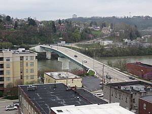
Westover viewed from across the Monongahela River
|
|

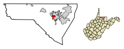
Location of Westover in Monongalia County, West Virginia.
|
|
| Country | |
| State | |
| County | |
| Area | |
| • Total | 1.50 sq mi (3.90 km2) |
| • Land | 1.50 sq mi (3.89 km2) |
| • Water | 0.00 sq mi (0.00 km2) |
| Elevation | 945 ft (288 m) |
| Population
(2020)
|
|
| • Total | 3,955 |
| • Estimate
(2021)
|
4,075 |
| • Density | 2,776.45/sq mi (1,072.10/km2) |
| Time zone | UTC-5 (Eastern (EST)) |
| • Summer (DST) | UTC-4 (EDT) |
| ZIP codes |
26501-26502
|
| Area code(s) | 304 |
| FIPS code | 54-85996 |
| GNIS feature ID | 1555960 |
| Website | https://www.westoverwv.org |
Westover is a city located in Monongalia County, West Virginia, United States. It sits right along the Monongahela River. In 2020, about 3,955 people lived there. Westover is also part of the larger Morgantown metropolitan area.
Contents
History of Westover
Westover got its name because it is located "over" the river from the city of Morgantown. The city of Westover officially became a city on October 12, 1911.
Over the years, Westover grew in size. It expanded to include nearby areas like Riverside in 1945. Later, in 1947, it added Morgan Heights, Fairmor, and Maple Grove. The area where Westover Park was built also became part of the city in 1955.
Where is Westover Located?
Westover is found at these coordinates: 39°38′6″N 79°58′28″W / 39.63500°N 79.97444°W. This helps pinpoint its exact spot on a map.
The city covers a total area of about 1.51 square miles (3.91 square kilometers). All of this area is land, with no large bodies of water inside the city limits.
People Living in Westover
| Historical population | |||
|---|---|---|---|
| Census | Pop. | %± | |
| 1920 | 721 | — | |
| 1930 | 1,633 | 126.5% | |
| 1940 | 1,752 | 7.3% | |
| 1950 | 4,318 | 146.5% | |
| 1960 | 4,749 | 10.0% | |
| 1970 | 5,086 | 7.1% | |
| 1980 | 4,884 | −4.0% | |
| 1990 | 4,201 | −14.0% | |
| 2000 | 3,941 | −6.2% | |
| 2010 | 3,983 | 1.1% | |
| 2020 | 3,955 | −0.7% | |
| 2021 (est.) | 4,075 | 2.3% | |
| U.S. Decennial Census | |||
Westover's Population in 2010
According to the census taken in 2010, there were 3,983 people living in Westover. These people lived in 1,845 households, and 990 of these were families.
The city had about 2,638 people per square mile (1,019 per square kilometer). There were also 2,016 housing units, which means homes or apartments.
Most of the people in Westover were White (91.2%). Other groups included African American (4.9%), Native American (0.3%), and Asian (1.1%). About 1.7% of the population identified as Hispanic or Latino.
Out of the 1,845 households, about 22.6% had children under 18 living with them. About 36.0% were married couples. Some households had a single female head (12.6%) or a single male head (5.0%). Many households (46.3%) were not families.
About 35.5% of all households had only one person living there. Around 11% of households had someone aged 65 or older living alone. On average, there were 2.16 people per household and 2.79 people per family.
The average age of people in Westover in 2010 was 38 years old. About 17.8% of residents were under 18. About 11.6% were between 18 and 24 years old. People aged 25 to 44 made up 28.5% of the population. Those aged 45 to 64 were 26.8%, and 15.1% were 65 or older. The population was almost evenly split between males (50.1%) and females (49.9%).
Schools in Westover
The schools in Westover are managed by Monongalia County Schools.
Students living in Westover typically attend these schools:
- Skyview Elementary School
- Westwood Middle School
- University High School
See also
 In Spanish: Westover (Virginia Occidental) para niños
 | Madam C. J. Walker |
 | Janet Emerson Bashen |
 | Annie Turnbo Malone |
 | Maggie L. Walker |

