Shavers Fork facts for kids
Quick facts for kids Shavers Fork |
|
|---|---|

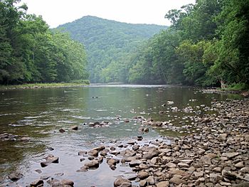
Shavers Fork at Stuart Recreation Area in the Monongahela National Forest
|
|

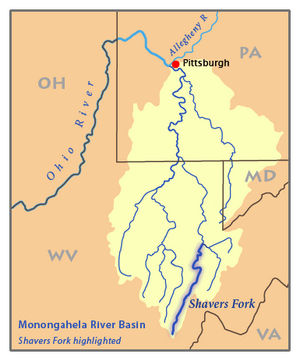
Map of the Monongahela River basin, with Shavers Fork highlighted.
|
|
| Country | United States |
| State | West Virginia |
| Counties | Tucker, Randolph, Pocahontas |
| Physical characteristics | |
| Main source | Thorny Flat, Cheat Mountain Pocahontas County, West Virginia 4,553 ft (1,388 m) 38°23′44″N 79°59′02″W / 38.39556°N 79.98389°W |
| River mouth | Cheat River Parsons, West Virginia 1,621 ft (494 m) 39°06′39″N 79°40′43″W / 39.11083°N 79.67861°W |
| Length | 89 mi (143 km) |
| Discharge (location 2) |
|
| Basin features | |
| Basin size | 214 sq mi (550 km2) |
The Shavers Fork of the Cheat River is a river located in the Allegheny Mountains of eastern West Virginia, USA. It is about 88.5 mi (142.4 km) long. This river joins with the Black Fork at Parsons to form the main Cheat River.
Shavers Fork is known as one of the five "Forks of Cheat." Its upper parts are considered the highest river in the eastern United States.
Contents
Understanding Shavers Fork Geography
Shavers Fork is part of a large watershed that eventually flows into the Mississippi River. A watershed is an area of land where all the water drains into a common river, lake, or ocean. The water from Shavers Fork travels through the Cheat, Monongahela, and Ohio Rivers before reaching the Mississippi.
Where Shavers Fork Begins
The river starts in north-central Pocahontas County. Its source is at Thorny Flat, which is the highest point of Cheat Mountain. This area is also home to the Snowshoe Mountain ski resort.
The very beginning of the river flows through a ghost town called Spruce. A ghost town is a place that used to have people living there but is now empty.
The River's Journey and Path
Shavers Fork generally flows north-northeast through Randolph and Tucker Counties. Its valley is located between Cheat Mountain to the west and Shavers Mountain to the east.
Along its path, the river passes by small communities like Cheat Bridge, Bemis, Bowden, and Porterwood. A few miles upstream from Bemis, you can find the "High Falls of Cheat," which is about 15 feet [4.6 m] tall.
Finally, Shavers Fork meets the Black Fork at Parsons. This meeting point is where the Cheat River officially begins, at an elevation of 1,621 ft (494 m). Most of the river flows through the Monongahela National Forest. About 97% of the land around the river is covered in forests, and two-thirds of it is public land.
Main Tributaries of Shavers Fork
The main rivers that flow into Shavers Fork are the Dry Fork and the Blackwater River. These two rivers join together to form the Black Fork river, which then meets Shavers Fork.
The Name Shavers Fork

The river was named after a local family called Shaver. Over time, the name has been spelled in different ways.
Historically, Shavers Fork has also been known by these names:
- Chavers Fork
- Main Cheat River
- Shafers Fork
- Shaffers Fork of Cheat River
- Shaver's Fork
- Shavers Fork River
- Shavers Fork of Cheat River
Fun Activities on Shavers Fork
Fishing in the River
Shavers Fork is a great place for fishing! Many record-breaking fish for West Virginia have been caught in its waters. This makes it a popular spot for anglers looking for a big catch.
See also
 | Stephanie Wilson |
 | Charles Bolden |
 | Ronald McNair |
 | Frederick D. Gregory |

