
Blackwater River (West Virginia) facts for kids
Quick facts for kids Blackwater River |
|
|---|---|

Blackwater River in Blackwater Canyon viewed from Lindy Point in Blackwater Falls State Park
|
|

Map of the Monongahela River basin, with the Blackwater River highlighted.
|
|
| Country | United States |
| State | West Virginia |
| County | Tucker |
| Physical characteristics | |
| Main source | Canaan Mountain Tucker County, WV 3,594 ft (1,095 m) 39°03′39″N 79°29′04″W / 39.06083°N 79.48444°W |
| River mouth | Black Fork Hendricks, WV 1,690 ft (520 m) 39°04′20″N 79°37′45″W / 39.07222°N 79.62917°W |
| Length | 34 mi (55 km) |
| Basin features | |
| Basin size | 142 sq mi (370 km2) |
| Tributaries |
|
The Blackwater River is a 34.3-mile (55.2 km) long river in the Allegheny Mountains of eastern West Virginia, USA. It is a main branch of the Cheat River. The Blackwater River is part of the larger Mississippi River system. It drains an area of 142 square miles (368 km²).
This river is a true blackwater stream. Its water gets a tea or amber color from tannins. These tannins come from spruce and hemlock trees in the area.
Contents
Where is the Blackwater River?
The Blackwater River is entirely within Tucker County. It starts on Canaan Mountain at 3,594 feet (1,095 m) high. At first, it flows slowly north-northeast through the wetlands of Canaan Valley.
It passes through Canaan Valley Resort State Park and the Canaan Valley National Wildlife Refuge. Along the way, it collects water from two smaller rivers: the North Branch Blackwater River and the Little Blackwater River. After this, the Blackwater River turns west-southwest for the rest of its journey.
Blackwater Falls and Canyon
After flowing past the town of Davis, the river drops 62 feet (19 m) over Blackwater Falls. Then, it enters the eight-mile (13 km) long Blackwater Canyon. This canyon is part of Blackwater Falls State Park.
Inside the canyon, the river creates exciting whitewater rapids. These rapids are rated as Class IV-V+, which means they are very challenging. Here, it also meets the eight-mile (13 km) long North Fork Blackwater River, which flows past the town of Thomas.
Finally, the Blackwater River joins the Dry Fork at the town of Hendricks. Together, they form the Black Fork. This meeting point is at an elevation of 1,690 feet (515 m).
Why is the Water Black?
The Blackwater River gets its dark color from natural substances called tannins. These tannins are released from decaying leaves and plants that grow near the river. The main sources are fallen needles from eastern hemlock and red spruce trees. Other plants like rhododendron, mountain laurel, and sphagnum bogs in Canaan Valley also add to the color.
Like other blackwater rivers, its water is usually clear, acidic, and has very few nutrients.
Protecting the River
For many years, the Blackwater River and its smaller streams faced big problems. Starting in the 1880s, mining and coke production caused a lot of pollution. This got worse in the 1960s and 1970s due to surface mining. The biggest issue was acid mine drainage (AMD).
What is Acid Mine Drainage?
AMD happens when rocks containing sulfite are exposed to air and rain. This often occurs during mining. When sulfite reacts, it creates sulfuric acid. This acid can then dissolve metals like iron, aluminum, and magnesium from the rocks. By 2004, AMD had damaged or destroyed about 12,000 miles (19,000 km) of streams in the Appalachia region, including parts of the Blackwater River.
How the River Was Cleaned Up
Cleaning up the Blackwater River watershed was a big and difficult job. One project involved using 16,000 tons (14,400 tonnes) of limestone to treat AMD. This was done on the North Fork Blackwater River. Limestone helps to neutralize the acid.
Another successful project was near Davis, on Beaver Creek, a small stream that flows into the Blackwater. A special station was built that grinds limestone into a powder and adds it to the water. This helps to clean the water as it flows.
Thanks to these efforts, a 5-mile (8 km) stretch of the Blackwater River is now a great place for trout fishing.
Images for kids
-
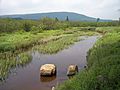
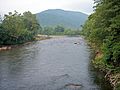
Upper reaches of the Blackwater River in the wetlands of Canaan Valley Resort State Park
-
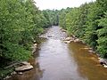
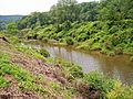
The Blackwater River near where it crosses into Blackwater Falls State Park
-
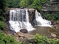
Blackwater Falls drops about 62' in Blackwater Falls State Park
-
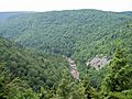
Blackwater River Gorge viewed from the lodge in Blackwater Falls State Park
-
Confluence with Dry Fork to form Black Fork
-
North Fork Blackwater River in Thomas
-
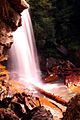
Douglas Falls (North Fork Falls), a drop of about 35' on the North Fork Blackwater River


See also
