Glady Fork facts for kids
Quick facts for kids Glady Fork |
|
|---|---|

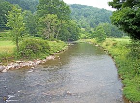
The Glady Fork in Randolph County in 2006
|
|
| Country | United States |
| State | West Virginia |
| Counties | Randolph, Tucker |
| Physical characteristics | |
| Main source | West Fork Glady Fork Lynn Divide, Randolph County 3,154 ft (961 m) 38°44′08″N 79°45′56″W / 38.73556°N 79.76556°W |
| 2nd source | East Fork Glady Fork Middle Mountain, Randolph County, WV 3,707 ft (1,130 m) 38°42′48″N 79°44′05″W / 38.71333°N 79.73472°W |
| River mouth | Dry Fork Gladwin, WV 1,946 ft (593 m) 39°00′33″N 79°32′48″W / 39.00917°N 79.54667°W |
| Length | 32 mi (51 km) |
| Basin features | |
| Basin size | 64 sq mi (170 km2) |
The Glady Fork is a river about 32 miles (51 kilometers) long in the Allegheny Mountains of eastern West Virginia, USA. It is one of the five main rivers that form the Cheat River. These five rivers are often called the "Forks of Cheat."
Contents
About the Glady Fork River
The Glady Fork is an important part of a much larger water system. It flows into the Dry Fork. From there, its waters travel through several other rivers. These include the Black Fork, the Cheat, the Monongahela, and the Ohio. Finally, the water reaches the mighty Mississippi River.
Where Does the Glady Fork Begin?
The Glady Fork starts in Randolph County. It is formed when two smaller streams meet. These streams are called the East Fork Glady Fork and the West Fork Glady Fork. They flow from a high area known as Lynn Divide. This divide separates the water that flows into the Cheat River from water that goes into the Greenbrier River.
How the River Flows
From where it begins, the Glady Fork flows mostly north. It winds its way between two mountains, Middle Mountain and Shavers Mountain. Much of its path is within the beautiful Monongahela National Forest. The river travels through eastern Randolph County and then into southern Tucker County. It eventually joins the Dry Fork river at a place called Gladwin.
Why is it Called Glady Fork?
The river got its name because of the "glades" found along its banks. Glades are open, grassy areas within a forest.
The River's Surroundings
Most of the land around the Glady Fork is covered in trees. About 94% of the area that drains into the river is forest. These are mostly deciduous trees, which means they lose their leaves in the fall.
Whitewater Fun
If you like adventure, the lower part of the Glady Fork offers exciting whitewater. The river has continuous Class 2 rapids. This means the water is moving fast with some waves. In the last three to four miles (5–6 km), the rapids become even more challenging, reaching Class 3.
 | Tommie Smith |
 | Simone Manuel |
 | Shani Davis |
 | Simone Biles |
 | Alice Coachman |

