Tygart Valley River facts for kids
Quick facts for kids Tygart Valley River |
|
|---|---|

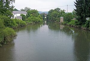
The Tygart Valley River at the mouth of the Buckhannon River (just above center). Photo taken along the B&O Railroad between Belington and Philippi.
|
|

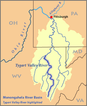
Map of the Monongahela River basin, with the Tygart Valley River highlighted
|
|
| Country | United States |
| State | West Virginia |
| Counties | Barbour, Marion, Pocahontas, Taylor, Randolph |
| Physical characteristics | |
| Main source | Allegheny Mountains Pocahontas County, WV 4,540 ft (1,380 m) 38°28′06″N 79°58′51″W / 38.46833°N 79.98083°W |
| River mouth | Monongahela River Fairmont, WV 863 ft (263 m) 39°27′54″N 80°09′11″W / 39.46500°N 80.15306°W |
| Length | 135 mi (217 km) |
| Discharge (location 2) |
|
| Basin features | |
| Basin size | 1,329 sq mi (3,440 km2) |
| Tributaries | |
The Tygart Valley River, also called the Tygart River, is a major river in West Virginia, United States. It flows for about 135 miles (217 km) through the eastern part of the state. This river is a tributary of the Monongahela River.
The Tygart Valley River is part of a huge water system. Its water eventually flows into the Ohio River and then into the mighty Mississippi River. The river drains an area of about 1,329 square miles (3,442 km²). This area includes parts of the Allegheny Mountains and the Allegheny Plateau.
Journey of the Tygart Valley River

The Tygart Valley River starts high up in the Allegheny Mountains. This is in Pocahontas County. From there, it flows mostly northwest through several counties. These counties include Randolph, Barbour, Taylor, and Marion.
As it travels, the river passes by many towns. Some of these towns are Huttonsville, Elkins, Philippi, and Grafton. Finally, it reaches Fairmont. Here, it meets the West Fork River to form the Monongahela River. You can think of the Tygart Valley River as the "East Fork" of the Monongahela.
Near Elkins, the river flows through a natural gap. This gap is between Rich Mountain and Laurel Mountain. These mountains mark the edge between the Alleghenies and the Allegheny Plateau.
Along its way, the Tygart Valley River collects water from smaller streams. These are called tributaries. Some important ones include Leading Creek near Elkins. The Middle Fork River and the Buckhannon River also join it in Barbour County. The Buckhannon River is its largest tributary.
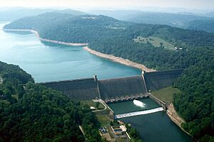
Just before Grafton, the river forms Tygart Lake. This lake was created in 1938 by a U.S. Army Corps of Engineers dam. Valley Falls State Park is also located along the river, between Grafton and Fairmont.
How Fast Does the River Flow?
Scientists measure how much water flows in rivers. This is called the "flow rate." At a special measuring station in Philippi, the river's average flow rate was 1,922 cubic feet per second (54 cubic meters per second) between 1940 and 2005.
The highest flow ever recorded there was huge! It was about 61,000 cubic feet per second (1,727 cubic meters per second) on November 5, 1985. The lowest flow was much smaller, only 4.9 cubic feet per second (0.1 cubic meters per second) in October 1953.
Another station near Dailey, further upstream, also measures the flow. Between 1915 and 2005, the average flow there was 358 cubic feet per second (10 cubic meters per second). Sometimes, the river flow was so low that it was recorded as zero for several months in 1930 and 1953.
A Look Back in Time
The Tygart Valley was first settled by European families in 1753. David Tygart, who the valley and river are named after, and Robert Files were among the first. They settled near where Beverly is today.
Sadly, a group of Native Americans discovered the Files family cabin. They killed several family members. One son escaped and warned the Tygart family, who were able to get away safely. No other European settlements were tried in that area until 1772.
Later, two brothers, John and Samuel Pringle, helped many new settlers come to the Tygart Valley. They had lived along the Buckhannon River since 1761. The valley was known for its many animals and rich farmland, which attracted new families.
Some of the families who settled there in the 1770s and 1780s included the Connelly, Jackson, and Wilson families. One settler, John Jackson, was the great-grandfather of a famous Civil War general, Thomas "Stonewall" Jackson.
During the American Civil War, some smaller battles happened in the Tygart Valley in 1861. These included the Battle of Philippi, the Battle of Laurel Hill, and the Battle of Cheat Mountain.
 | Laphonza Butler |
 | Daisy Bates |
 | Elizabeth Piper Ensley |


