Huttonsville, West Virginia facts for kids
Quick facts for kids
Huttonsville, West Virginia
|
|
|---|---|

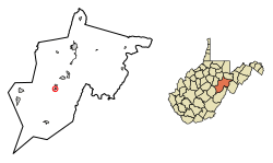
Location of Huttonsville in Randolph County, West Virginia.
|
|
| Country | United States |
| State | West Virginia |
| County | Randolph |
| Area | |
| • Total | 0.30 sq mi (0.78 km2) |
| • Land | 0.30 sq mi (0.78 km2) |
| • Water | 0.00 sq mi (0.00 km2) |
| Elevation | 2,037 ft (621 m) |
| Population
(2020)
|
|
| • Total | 163 |
| • Estimate
(2021)
|
162 |
| • Density | 693.07/sq mi (267.58/km2) |
| Time zone | UTC-5 (Eastern (EST)) |
| • Summer (DST) | UTC-4 (EDT) |
| ZIP code |
26273
|
| Area code(s) | 304 |
| FIPS code | 54-39628 |
| GNIS feature ID | 1551537 |
| Website | https://townofhuttonsville.com/ |
Huttonsville is a small town in Randolph County, West Virginia, United States. It is located along the Tygart Valley River. In 2020, about 163 people lived there.
Contents
History of Huttonsville
Huttonsville got its name from Jonathan Hutton. He was one of the first settlers in the area. These early settlers were called pioneers.
Historic Buildings and Sites
Huttonsville is home to some important historical places. The E. E. Hutton House and the Tygarts Valley Church are two of them. These buildings are listed on the National Register of Historic Places. This means they are special places that are worth protecting.
Close to Huttonsville, you can find other historic sites. These include the old Cheat Summit Fort and Fort Marrow. They are also on the National Register of Historic Places.
Geography and Climate
Huttonsville is located at coordinates 38.713266 degrees North and -79.977329 degrees West. The town covers an area of about 0.30 square miles (0.78 square kilometers). All of this area is land.
Weather in Huttonsville
The weather in Huttonsville is generally mild. This means there are not huge differences between the highest and lowest temperatures. The area also gets enough rain throughout the year.
Population Facts
| Historical population | |||
|---|---|---|---|
| Census | Pop. | %± | |
| 1910 | 251 | — | |
| 1920 | 265 | 5.6% | |
| 1930 | 303 | 14.3% | |
| 1940 | 308 | 1.7% | |
| 1950 | 227 | −26.3% | |
| 1960 | 242 | 6.6% | |
| 1970 | 167 | −31.0% | |
| 1980 | 242 | 44.9% | |
| 1990 | 211 | −12.8% | |
| 2000 | 217 | 2.8% | |
| 2010 | 221 | 1.8% | |
| 2020 | 163 | −26.2% | |
| 2021 (est.) | 162 | −26.7% | |
| U.S. Decennial Census | |||
Huttonsville's Population in 2010
In 2010, there were 221 people living in Huttonsville. These people lived in 87 different homes. About 56 of these homes were families.
The town had about 737 people per square mile. Most of the people living in Huttonsville were White (99.5%). A small number (0.5%) were from two or more races. About 2.3% of the people were Hispanic or Latino.
Households and Families
In 2010, about one-third of the homes (33.3%) had children under 18 years old. Many homes (40.2%) were married couples living together. Some homes had a female head (13.8%) or a male head (10.3%) without a spouse. About 35.6% of homes were not families.
Almost one-third of homes (31.0%) had only one person living there. About 18.3% of homes had one person who was 65 or older. On average, there were 2.54 people in each home. For families, the average size was 3.11 people.
Age and Gender
The average age of people in Huttonsville in 2010 was 32.4 years.
- About 28.1% of residents were under 18.
- About 12.6% were between 18 and 24 years old.
- About 21.7% were between 25 and 44 years old.
- About 23% were between 45 and 64 years old.
- About 14.5% were 65 years or older.
In terms of gender, 48.0% of the town's population was male. The other 52.0% was female.
See also
 In Spanish: Huttonsville (Virginia Occidental) para niños
 | Leon Lynch |
 | Milton P. Webster |
 | Ferdinand Smith |

