Laurel Mountain (West Virginia) facts for kids
Quick facts for kids Laurel Mountain, West Virginia |
|
|---|---|
 |
|
| Highest point | |
| Elevation | 3,157 ft (962 m) |
| Geography | |
| Location | West Virginia, U.S. |
| Parent range | Allegheny Mountains, part of the Ridge-and-Valley Appalachians |
| Topo map | USGS Colebank |
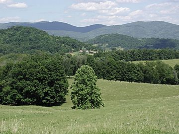
Laurel Mountain, also known as Laurel Hill, is a long mountain ridge in north-central West Virginia, U.S.. It is seen as the western edge of the Allegheny Mountains. It also marks the border between the Alleghenies and the Allegheny Plateau.
Contents
Exploring Laurel Mountain's Geography
Laurel Mountain stretches from the northeast to the southwest. It runs through Preston, Tucker, Barbour, and Randolph Counties. This ridge forms parts of the borders between these counties.
How Long is Laurel Mountain?
The mountain is about 32 miles (51 km) long. It starts near the Cheat River in the north. It ends near the Tygart Valley River in the south. Its highest point is called the Eliot Benchmark. This spot is 3,157 feet (962 meters) high.
How Laurel Mountain Was Formed
Laurel Mountain was created by a natural fold in the Earth's crust. This same fold continues north as the Briery Mountains. To the south, it becomes Rich Mountain. Laurel Mountain is a great example of the long, folded mountains found in the Appalachian Valley and Ridge Region. It sits right on the western edge of this special area.
Laurel Mountain's Past: A Look at History
Laurel Mountain got its name from the many "great laurel" plants. These plants, also known as Rhododendron maximum, grew everywhere. Early settlers found them in large numbers in the late 1700s.
The Civil War at Laurel Mountain
Laurel Mountain played a part in the American Civil War. After the Battle of Philippi on June 3, 1861, Confederate soldiers retreated. Confederate General Robert S. Garnett moved about 3,500 troops to Laurel Mountain. They set up camp near the Laurel Mountain Road. This road is now a winding dirt road connecting Belington and Elkins.
On July 6, Union General George B. McClellan ordered his troops to advance. General Thomas A. Morris led about 5,000 Union soldiers to Belington. Small fights, called skirmishes, began on July 7. These fights lasted for five days and are known as the "Battle of Laurel Hill." The Union forces won, making the Confederate troops retreat. General Garnett then moved his troops to Corrick's Ford. He was later killed there, becoming the first general officer to die in the war.
Later Civil War Events
Later that summer, General Robert E. Lee tried to fight Union forces near Cheat Mountain. He also tried to operate in the Tygart Valley. He eventually stopped his attack and pulled back his troops. In October, he tried again to fight at Laurel Mountain. However, problems with communication and supplies stopped his plans. General Lee was called back to Richmond on October 30. His efforts in western Virginia had not been very successful.
Remembering the Past Today
In recent years, people have held a "Battle of Laurel Hill Reenactment." This event takes place at the Laurel Hill Battlefield on the anniversary of the battle. In 2004, the city of Belington took ownership of 50 acres (200,000 m2) of the old camp and battlefield.
Wind Power on Laurel Mountain
The AES Corporation has built wind turbines on Laurel Mountain. This wind farm opened in October 2011. It has 61 turbines spread out over 12 miles (19 km). These turbines can create up to 98 megawatts of electricity.
How Batteries Help Wind Power
A special part of this project is a very large battery system. It is the biggest battery setup connected to the power grid in the continental United States. These 1.3 million batteries help to make the wind power more stable. Wind energy can change a lot, but the batteries act like a "shock absorber." They make the power output smoother and more useful for the electricity grid.
 | Isaac Myers |
 | D. Hamilton Jackson |
 | A. Philip Randolph |

