Middle Fork River facts for kids
Quick facts for kids Middle Fork River |
|
|---|---|

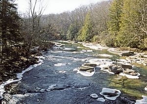
The Middle Fork River in Audra State Park in 2005
|
|

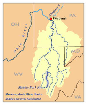
Map of the Monongahela River basin, with the Middle Fork River highlighted
|
|
| Country | United States |
| State | West Virginia |
| Physical characteristics | |
| Main source | Kittle Creek Rich Mountain, Randolph County 3,639 ft (1,109 m) 38°40′03″N 80°04′45″W / 38.66750°N 80.07917°W |
| 2nd source | Birch Fork Rocky Ridge, Randolph County 3,493 ft (1,065 m) 38°40′47″N 80°05′58″W / 38.67972°N 80.09944°W |
| River mouth | Tygart Valley River Barbour County 1,483 ft (452 m) 39°03′41″N 80°02′51″W / 39.06139°N 80.04750°W |
| Length | 35 mi (56 km) |
| Basin features | |
| Basin size | 152 sq mi (390 km2) |
The Middle Fork River is a river in north-central West Virginia, USA. It is about 35.4-mile-long (57.0 km). This river flows into the Tygart Valley River. From there, its water eventually reaches the Monongahela River, then the Ohio River, and finally the mighty Mississippi River.
The Middle Fork River is part of a large area called a watershed. This means all the rain and water that falls on this 152 square miles (390 km2) area flows into the Middle Fork River. This area is on the eastern edge of the Allegheny Plateau, a high, flat landform. The Middle Fork River has also been called "Middle Fork" or "Middlefork."
Where the River Flows
The Middle Fork River starts in western Randolph County. It forms where two smaller streams, Kittle Creek and Birch Fork, meet. These streams are each about 6.5 miles (10.5 km) long. They begin north of Kumbrabow State Forest and flow north. Kittle Creek starts on the side of Rich Mountain. This mountain is part of the Allegheny Mountains.
From where it starts, the Middle Fork River flows mostly north. It runs alongside Rich Mountain. The river helps form the border between Randolph and Upshur counties. Then it forms the border between Upshur and Barbour counties. Finally, it flows into southern Barbour County.
The Middle Fork River joins the Tygart Valley River about 5 miles (8 km) south of Philippi. Before it joins, it flows through Audra State Park. This park was created in the mid-1900s. It offers places to camp and a swimming beach along the river. Another stream, called the Right Fork Middle Fork River, also flows into the Middle Fork River in Upshur County.
River Adventures and Nature
For most of its path, the Middle Fork River has exciting whitewater rapids. These rapids are rated from Class I (easy) to Class IV (difficult) on a special scale. The section of the river from Audra State Park down to where it ends has Class IV rapids. This means it's a challenging and thrilling ride for experienced rafters!
Most of the land around the Middle Fork River is covered in forests. About 94% of the watershed is forested, mostly with trees that lose their leaves in the fall. About 4% of the land is used for farming and pastures. This shows how natural and wild the area around the river is.
How Fast the River Flows
Scientists measure how much water flows in the Middle Fork River. At Audra State Park, there is a special station called a USGS stream gauge. Between 1942 and 2005, the river's average flow was 356 cubic feet per second (10 cubic meters per second).
The most water ever recorded flowing through the river was on May 17, 1996. On that day, it flowed at 16,700 cubic feet per second (473 cubic meters per second). The least amount of water recorded was just 0.2 cubic feet per second (0 cubic meters per second). This happened on several days in October 1953.
 | Emma Amos |
 | Edward Mitchell Bannister |
 | Larry D. Alexander |
 | Ernie Barnes |

