Beverly, West Virginia facts for kids
Quick facts for kids
Beverly, West Virginia
|
||
|---|---|---|

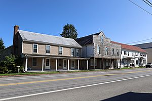
Buildings in Beverly Historic District in 2021
|
||
|
||

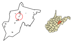
Location of Beverly in Randolph County, West Virginia.
|
||
| Country | United States | |
| State | West Virginia | |
| County | Randolph | |
| Area | ||
| • Total | 0.44 sq mi (1.14 km2) | |
| • Land | 0.44 sq mi (1.14 km2) | |
| • Water | 0.00 sq mi (0.00 km2) | |
| Elevation | 1,962 ft (598 m) | |
| Population
(2020)
|
||
| • Total | 628 | |
| • Estimate
(2021)
|
623 | |
| • Density | 1,517.08/sq mi (585.65/km2) | |
| Time zone | UTC-5 (Eastern (EST)) | |
| • Summer (DST) | UTC-4 (EDT) | |
| ZIP code |
26253
|
|
| Area code(s) | 304 | |
| FIPS code | 54-06988 | |
| GNIS feature ID | 1553884 | |
| Website | https://townofbeverly.com/ | |
Beverly is a small town in Randolph County, West Virginia, USA. It was founded in 1787, making it the oldest town in the Tygart River Valley. In 2020, about 628 people lived there. Beverly used to be the main town (called the county seat) for Randolph County for over 100 years. But then, another town called Elkins took over after a big local disagreement about where the county seat should be.
Contents
History of Beverly
Early Settlers and Town Beginnings
The very first European settlers in the Tygart Valley arrived in 1753. David Tygart, who the valley and river are named after, and Robert Files built cabins. After some early conflicts, no more settlements were tried in this area until 1772.
On May 29, 1787, leaders of the new Randolph County decided to create a town. They asked James Westfall, a local landowner, to plan out the town. At first, it was called Edmundton. This name honored Virginia Governor Edmund Randolph.
In December 1790, the Virginia government officially named the town "Beverley." By this time, Beverley Randolph, a cousin of Edmund, was governor. The town was renamed for him. Soon after, the third "e" was dropped, and it became "Beverly."
The government told citizens to build houses that were "sixteen feet square with a brick or stone chimney." The first homes, along with a courthouse, jail, and school, were simple log cabins. Back then, Randolph County was much larger than it is today. It included parts of many other counties.
Growth and the Civil War
In 1794, Jacob Westfall got permission to build a sawmill near the town. This meant people could start building houses with wooden frames instead of just logs.
When the Staunton-Parkersburg Turnpike (a major road) arrived in 1841, Beverly grew quickly. It became an important center for travel and trade in the region.
During the American Civil War (1861–1865), both Union and Confederate soldiers occupied Beverly at different times. Many buildings were used as hospitals or places for soldiers to stay.
In January 1865, a Confederate general named Thomas L. Rosser led 300 men through deep snow to Beverly. They surprised and captured about 580 Union soldiers. Rosser's troops also partly burned the Beverly Covered Bridge. This bridge was built in 1846–1847 by a famous builder named Lemuel Chenoweth. He rebuilt it a few years later in 1872 and 1873.
Losing the County Seat
Beverly was the county seat for over 100 years. This meant it was the main town where the county government was located. However, in 1899, Beverly lost this important role to Elkins. Elkins was growing fast because of railroads and the timber industry.
In 1980, the entire town of Beverly was added to the National Register of Historic Places. This means it's recognized as a place with important history. Today, many of Beverly's old buildings have been fixed up and look great.
Geography and Climate
Where is Beverly?
Beverly is located in West Virginia at these coordinates: 38°51′2″N 79°52′3″W / 38.85056°N 79.86750°W.
The United States Census Bureau says the town covers about 0.45 square miles (1.14 square kilometers). All of this area is land.
What is Beverly's Climate Like?
Beverly has a humid continental climate. This means it has big changes in temperature throughout the year. Summers are warm to hot and often humid. Winters are cold, and sometimes very cold.
Population and People
How Many People Live in Beverly?
| Historical population | |||
|---|---|---|---|
| Census | Pop. | %± | |
| 1880 | 235 | — | |
| 1890 | 343 | 46.0% | |
| 1900 | 464 | 35.3% | |
| 1910 | 438 | −5.6% | |
| 1920 | 442 | 0.9% | |
| 1930 | 431 | −2.5% | |
| 1940 | 484 | 12.3% | |
| 1950 | 515 | 6.4% | |
| 1960 | 441 | −14.4% | |
| 1970 | 470 | 6.6% | |
| 1980 | 475 | 1.1% | |
| 1990 | 696 | 46.5% | |
| 2000 | 651 | −6.5% | |
| 2010 | 702 | 7.8% | |
| 2020 | 628 | −10.5% | |
| 2021 (est.) | 623 | −11.3% | |
| U.S. Decennial Census | |||
The table above shows how Beverly's population has changed over many years.
2010 Census Information
According to the census from 2010, there were 702 people living in Beverly. These people made up 323 households and 199 families.
The town had about 1560 people per square mile. Most of the people living in Beverly (98%) were White. A small number were African American or Native American. About 1.4% of the people were from two or more racial backgrounds.
About 30% of the households had children under 18 living there. Many households (36.2%) were married couples. About 33.4% of all households were made up of people living alone. The average age of people in Beverly was 40.5 years old.
See also
 In Spanish: Beverly (Virginia Occidental) para niños
 | Chris Smalls |
 | Fred Hampton |
 | Ralph Abernathy |


