
Powell Mountain facts for kids
Powell Mountain is a long, narrow mountain ridge in the Appalachian Mountains. It stretches from Norton, Virginia, all the way to Tazewell, Tennessee. This ridge helps separate the lands drained by the Clinch River from the lands drained by the Powell River. An explorer from the 1700s gave the mountain its name.
The mountain's height is usually between 1,500 to 2,500 feet (about 457 to 762 meters). Some parts are even taller than 3,000 feet (about 914 meters). The very highest spot is Bowling Knob, which is 3,557 feet (1,084 meters) high.
Powell Mountain is about 60 miles (97 kilometers) long. Only one river cuts through it: the North Fork Clinch River. North of this river, the mountain ridge isn't as clear. It blends into other mountains like Stone Mountain.
South of Powell Mountain, you'll find other ridges like Newman Ridge and Stone Ridge. The area between these ridges is known for its historic Melungeon people.
You can cross Powell Mountain using U.S. Route 58, which is also called "Daniel Boone Trail Highway." The original Wilderness Road also crossed the mountain nearby at a spot called Kanes Gap.
Besides the large river gap, there are many "wind gaps." These are low spots in the ridge where wind often blows through. Some of these gaps are Fugate Gap, Mulberry Gap (used by State Route 63), Hunter Gap (used by State Route 70), and Kanes Gap.
Contents
Exploring Powell Mountain

Let's take a journey along Powell Mountain from its southern end to its northern tip.
Southern End in Tennessee
Powell Mountain starts in Claiborne County, Tennessee. Small creeks flow on both sides of the mountain here. These creeks eventually join the Clinch River and flow into Norris Lake.
As you move northeast, the mountain enters Hancock County, Tennessee. Here, Newman Ridge runs very close to Powell Mountain on its south side. The mountain in Hancock County reaches heights of about 2,300 to 2,400 feet (700 to 730 meters). The highest point in this area is 2,501 feet (762 meters), right on the border between Tennessee and Virginia.
Into Virginia
Next, Powell Mountain crosses into Lee County, Virginia. Creeks that feed the Powell River flow on the north side. Creeks that feed the Clinch River flow on the south side. The historic Wilderness Road followed some of these creeks.
State Route 70 crosses Powell Mountain at Hunter Gap. Northeast of this gap, the mountain gets taller, reaching 2,500 feet (762 meters) and more.
Crossing the Mountain
Powell Mountain forms the border between Lee County and Scott County, Virginia. This is where U.S. Route 58, the "Daniel Boone Trail Highway," crosses the mountain. The original Wilderness Road crossed at Kanes Gap, which is just a bit northeast of where the modern highway is today.
Northeast of Kanes Gap, the North Fork Clinch River breaks through Powell Mountain. The mountain then curves around the river. US Route 23 and railroad tracks also follow the North Fork Clinch River through this gap.
Northern Sections
After the North Fork Clinch River, Powell Mountain continues but is less clearly a single ridge. It starts to blend with other mountains like Cliff Mountain and Stone Mountain. Near Cliff Mountain is Bowling Knob, the highest point on Powell Mountain at 3,557 feet (1,084 meters).
Close to this part of Powell Mountain, you can find Natural Tunnel State Park in Virginia. A difficult part of the old Wilderness Road, known as "Devil's Racepath," was also nearby. Crossing Powell Mountain at Kanes Gap and then dealing with Devil's Racepath made this a very challenging part of the journey for early travelers.
The northernmost part of Powell Mountain goes into Wise County, Virginia. Here, you'll find another high point called Morris Butt, which is 2,940 feet (896 meters) high. Further northeast, the Powell River's beginnings cut a valley into the mountain.
Finally, Powell Mountain gradually merges with other ridges like Little Mountain and Stone Mountain. The very highest point in this area is High Knob, at 4,223 feet (1,287 meters). However, High Knob is considered part of Stone Mountain, not Powell Mountain. Powell Mountain eventually ends near Norton, Virginia.
A large part of the northern section of Powell Mountain is within the Jefferson National Forest.
Images for kids
-
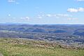
Scenery from U.S. Route 58 at the summit, Scott County, Virginia
