Braddock Road (Braddock expedition) facts for kids
The Braddock Road was a special military road built in 1755. It was located in what was then British America, which is now the United States. This road was the first improved path to cross the tough Appalachian Mountains.
British soldiers and Virginia militia troops built the road. They were led by General Edward Braddock. This was part of an important trip called the Braddock Expedition. Their goal was to take control of the Ohio Country from the French during the French and Indian War. This war was also part of a bigger worldwide conflict called the Seven Years' War.
A young George Washington was a helper to General Braddock. He learned a lot about military life during this expedition. Many American officers gained valuable experience here, which helped them later in the American Revolutionary War.
Building the Road
In 1755, General Braddock was sent to remove the French from Fort Duquesne, which is now Pittsburgh. He started his journey from Fort Cumberland.
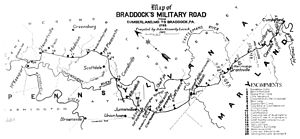
Braddock ordered 600 men to build a military road over Haystack Mountain. This road followed an old Native American trail known as Nemacolin's Path. George Washington and Christopher Gist had already improved parts of this path. The first job was to build the road about 20 miles to a place called Little Meadows.
After one day, the road builders had only completed two miles of road. They also broke three wagons trying to get over the very difficult mountain land. General Braddock was about to send more men to help. But then, a naval officer named Lt. Spendlowe told him about an easier way through a narrow pass.
Braddock decided to take about 1400 men and their wagons along Spendlowe's easier route. They later joined up with the first road at a place called Spendlowe's Camp, which is in LaVale, Maryland today.
Braddock's Defeat and Legacy
General Braddock's forces were defeated east of Fort Duquesne. Braddock himself was badly wounded and later died. He was buried in the middle of the road he had built. His soldiers marched over his grave to hide its location from the Native Americans.
Years later, road workers found his grave. His remains were moved, and a marble monument was put up in 1913 to mark the new site.
Another British expedition, led by General Forbes in 1758, also tried to capture Fort Duquesne. They were successful, but they used a different route through the mountains. This new path became known as Forbes' Road.
The Cumberland Road, which later became part of the National Road and then U.S. Route 40, generally follows a similar path to Braddock's Road. This is true between Cumberland, Maryland, and Laurel Ridge near Uniontown.
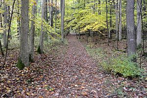
In the early 1900s, a Harvard professor named John Kennedy Lacock found the exact path of Braddock's march. He hired a photographer to take pictures of the road. Lacock published these photos as postcards in 1910. He also wrote about his findings in a magazine in 1914. The road Lacock found was one that many settlers had used for over 30 years after Braddock built it.
 | William L. Dawson |
 | W. E. B. Du Bois |
 | Harry Belafonte |


