Laurel Hill (Pennsylvania) facts for kids
Quick facts for kids Laurel Hill |
|
|---|---|

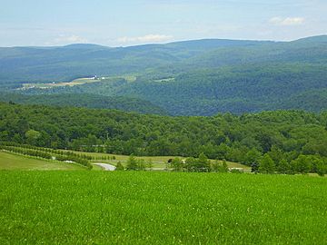
Laurel Hill from Kentuck Knob, Pennsylvania
|
|
| Highest point | |
| Elevation | 2,994 ft (913 m) |
| Geography | |
| Location | Pennsylvania, U.S. |
| Parent range | Allegheny Mountains |
| Topo map | USGS Ohiopyle, Mill Run, Kingwood, Seven Springs, Bakersville, Ligonier, Boswell, Rachelwood, Vintondale, Johnstown, New Florence (PA) Quadrangle |
| Climbing | |
| First ascent | unknown |
| Easiest route | drive up and hike |
Laurel Hill, also called Laurel Ridge or Laurel Mountain, is a long mountain in Pennsylvania. It stretches about 70 miles (113 km) through the Allegheny Mountains. This mountain ridge has Negro Mountain to its east and Chestnut Ridge to its west.
Laurel Hill is a great place for outdoor fun! It has six state parks: Laurel Ridge State Park, Laurel Mountain State Park, Linn Run State Park, Kooser State Park, Laurel Hill State Park, and Ohiopyle State Park. Plus, the 70-mile (113 km) Laurel Highlands Hiking Trail runs all along the ridge.
Two state forests, Gallitzin State Forest and Forbes State Forest, are found on Laurel Hill. They cover more than 22,000 acres (89 km²). Also, State Game Lands 42 and 111 are here, covering another 22,000 acres (89 km²).
Laurel Hill is about 2,700 feet (823 m) high on average. But some parts, called "knobs," rise even higher than 2,900 feet (884 m). The highest point is near the Seven Springs Mountain Resort, reaching 2,994 feet (913 m).
The mountain is bordered by two deep river gaps. To the north is the Conemaugh Gorge. To the south is the Youghiogheny Gorge. Both are about 1,700 feet (518 m) deep. North of the Conemaugh Gorge, the ridge continues as Rager Mountain, which is about 2,580 feet (786 m) high. South of the Youghiogheny Gorge, a shorter part of Laurel Hill reaches over 2,920 feet (890 m).
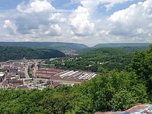
Near the northern end of Laurel Hill are the city of Johnstown and the historic town of Ligonier. Towards the southern end, you'll find the towns of Confluence and Ohiopyle, known for recreation. Two major highways cross Laurel Hill: the Pennsylvania Turnpike and U.S. Route 30. There's also an old, unused tunnel called the Laurel Hill Tunnel that goes under the mountain. Many smaller state roads also cross the mountain at different spots.
Understanding Laurel Hill's Geology
Laurel Hill is made of different types of sedimentary rocks. These rocks formed during the Mississippian and Pennsylvanian periods. They are mostly conglomerate (rocks made of pebbles), sandstone, and shale. Some of the rock layers include the Burgoon, Mauch Chunk, Pottsville, and Allegheny formations. The mountain itself is shaped like an anticline, which means its rock layers are folded upwards like an arch.
Along the top of Laurel Hill, there are several noticeable high points, or "knobs." These are like small peaks rising from the main ridge. From south to north, they include:
- Sugarloaf Knob (2,667 ft or 813 m)
- Highpoint (2,994 ft or 913 m)
- Birch Rock Hill (2,934 ft or 894 m)
- Painter Rock Hill (2,920 ft or 890 m)
- Bald Knob (2,930 ft or 893 m)
- Ulery Hill (2,820 ft or 860 m)
- Pea Vine Hill (2,900 ft or 884 m)
- Pikes Peak (2,840 ft or 866 m)
- Mystery Hill (2,880 ft or 878 m)
- Sugar Camp Hill (2,908 ft or 886 m)
Laurel Hill's Climate and Weather
Laurel Hill has a humid continental climate, similar to much of the eastern United States. However, the mountain ridge itself affects the local weather. Air temperatures on the mountain can be several degrees cooler than in the nearby towns and valleys. You might notice a difference of 5 to 10 degrees Fahrenheit (3 to 6 degrees Celsius) depending on the weather.
The mountain's shape, called orography, combined with moisture from the Great Lakes, can cause a lot of snow in winter. The ridge stands at a right angle to incoming weather systems. This forces the air flowing from the west to rise. As the air goes up, it cools. When it cools enough, the moisture in the air turns into rain or snow. Laurel Hill can also act like a wall, slowing down storms and creating a "micro-climate" in the area. Even though the mountain isn't super tall, it's high enough to gently change the weather, making it cooler or causing more rain or snow.
Animals and Plants of Laurel Hill
Laurel Hill has many different types of habitats, which means it's home to a wide variety of birds and mammals. You can often see ravens and wild turkeys on this mountain. Birds like the hermit thrush, Canada warbler, brown creeper, and winter wren build their nests near the bog at Spruce Flats. In the summer, you might spot black-throated and blue warblers, and solitary and red-eyed vireos.
Birds of prey, known as raptors, also live here. These include the broad-winged, red-tailed, and red-shouldered hawks, along with barred owls.
Some common mammals you might see on the mountain are white-tailed deer, chipmunks, and red and gray squirrels. Other animals that are harder to spot include the woodchuck, raccoon, and opossum. Black bears have also been seen, but they are shy and usually stay away from people.
Snakes also live on Laurel Hill, including the timber rattler and copperhead snakes. It's a good idea to be careful during the summer months when you are hiking around rocks and areas with loose stones.
 |
 |
|||
| Chestnut Ridge | Allegheny Mountain | |||
| Negro Mountain |
 | Laphonza Butler |
 | Daisy Bates |
 | Elizabeth Piper Ensley |


