
Ligonier, Pennsylvania facts for kids
Quick facts for kids
Ligonier, Pennsylvania
|
|||
|---|---|---|---|
|
Borough
|
|||
| Borough of Ligonier | |||

Ligonier, Pennsylvania
|
|||
|
|||
| Etymology: John Ligonier | |||

Location of Ligonier in Westmoreland County, Pennsylvania.
|
|||
.svg)
Location of Pennsylvania in the United States
|
|||
| Country | United States | ||
| State | Pennsylvania | ||
| County | Westmoreland | ||
| Fort established | 1758 | ||
| Town settled | 1817 | ||
| Borough incorporated | April 10, 1834 | ||
| Founded by | Colonel John Ramsey | ||
| Named for | John Ligonier | ||
| Government | |||
| • Body | Ligonier mayor | ||
| Area | |||
| • Total | 0.50 sq mi (1.31 km2) | ||
| • Land | 0.50 sq mi (1.31 km2) | ||
| • Water | 0.00 sq mi (0.00 km2) | ||
| Elevation | 1,197 ft (365 m) | ||
| Population
(2020)
|
|||
| • Total | 1,513 | ||
| • Density | 3,001.98/sq mi (1,159.02/km2) | ||
| Time zone | UTC-5 (EST) | ||
| • Summer (DST) | UTC-4 (EDT) | ||
| ZIP code |
15658
|
||
| Area codes | 724, 878 | ||
| FIPS code | 42-43232 | ||
| School District | Ligonier Valley School District | ||


Ligonier is a small town, called a borough, in Westmoreland County, Pennsylvania, United States. In 2020, about 1,513 people lived there. Ligonier was first settled in the 1760s.
This town is famous for a few cool places nearby. One is Idlewild Park, which is one of the oldest amusement parks in the whole country! Another is Seven Springs Mountain Resort, a popular spot for outdoor fun.
Ligonier also hosts fun events. Every fall, there's Fort Ligonier Days, a big parade and craft market. During the summer, you can visit the Ligonier Country Market. The town is also known for its central square, called the Diamond, which has a bandstand in the middle.
Contents
History of Ligonier
Early Settlement and Fort Ligonier
In 1758, during the French and Indian War, British soldiers built a fort here. They were trying to push French forces away from the Ohio River area, which is now Pittsburgh. This fort, called Fort Ligonier, was their last stop before reaching the Ohio.
At that time, the British army was huge, like a moving city with 6,000 people. This made Ligonier the second-biggest place in Pennsylvania, right after Philadelphia. The fort was named after John Ligonier, a British noble who was a very important general. Later, the town that grew around the fort was simply called Ligonier.

Growth and Challenges
In 1817, a new gravel road called the Philadelphia-Pittsburgh Turnpike was finished. This road was an early version of today's US Route 30. Fort Ligonier was a good place for travelers to stop and rest. Seeing this chance for business, a local person named John Ramsay planned the town's streets, including the central area now known as the Diamond.
He first named the town Ramseytown, then Wellington, and finally, it became Ligonier. The town grew and did well for many years. On April 10, 1834, Ligonier officially became a borough.
However, in 1852, the Pennsylvania Railroad was built. It went through other towns like Bolivar and Latrobe, bypassing Ligonier. People started using trains instead of horse-drawn wagons. This caused Ligonier's population to shrink to only 350 people by 1860.
Railroad and Resort Town
Ligonier got a boost when the Ligonier Valley Railroad was finished in 1877. This railroad connected Ligonier to Latrobe, where people could catch the Pennsylvania Railroad. The Ligonier Valley Railroad helped transport wood, coal, and stone out of the Ligonier Valley. This helped the town grow again.
The railroad also made it easier for people from Pittsburgh to visit Ligonier. Because of this, Ligonier became a popular summer resort town. During this time, the town changed a lot. In 1894, the Diamond, which used to be a place for horses and wagons, was turned into a park with a bandstand. A large hotel, the Hotel Breniser, was built in 1900. In 1909–1910, the Ligonier Valley Railroad built a fancy station and office building, which you can still see today at 339 West Main Street.
Modern Times
The Ligonier Valley Railroad stopped running in 1952. This happened because there was less wood to cut, the coal industry slowed down, and more people started using cars instead of trains.
Ligonier has three places listed on the National Register of Historic Places. These are the Fort Ligonier site, the Ligonier Historic District (which includes the Diamond and the oldest parts of town), and the former Ligonier Armory.
The Mellon family, a very rich banking family, owns a lot of land around Ligonier. Their large estate, Huntland Downs, is near Ligonier and covers about 30,000 acres (120 km²).
Media and News
Ligonier gets its news and media from two main areas: Pittsburgh and Johnstown-Altoona.
Population Facts
| Historical population | |||
|---|---|---|---|
| Census | Pop. | %± | |
| 1840 | 294 | — | |
| 1850 | 378 | 28.6% | |
| 1860 | 351 | −7.1% | |
| 1870 | 317 | −9.7% | |
| 1880 | 634 | 100.0% | |
| 1890 | 782 | 23.3% | |
| 1900 | 1,259 | 61.0% | |
| 1910 | 1,575 | 25.1% | |
| 1920 | 1,807 | 14.7% | |
| 1930 | 1,978 | 9.5% | |
| 1940 | 2,111 | 6.7% | |
| 1950 | 2,160 | 2.3% | |
| 1960 | 2,276 | 5.4% | |
| 1970 | 2,258 | −0.8% | |
| 1980 | 1,917 | −15.1% | |
| 1990 | 1,638 | −14.6% | |
| 2000 | 1,695 | 3.5% | |
| 2010 | 1,573 | −7.2% | |
| 2020 | 1,513 | −3.8% | |
| Sources: | |||
In 2000, there were 1,695 people living in Ligonier. Most of the people living there were White (99.76%). A small number were Asian (0.06%) or from two or more races (0.18%). About 0.35% of the population was Hispanic or Latino.
Geography of Ligonier
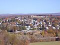
The town of Ligonier is completely surrounded by Ligonier Township. Ligonier is a small area, covering about 0.5 square miles (1.3 km²), and all of it is land. You can find Ligonier at these coordinates: 40°14′40″N 79°14′13″W.
Famous People from Ligonier
- Arthur St. Clair: A Major General and hero in the American Revolutionary War. He was also the 9th President of the Continental Congress.
- Garrett Smithley: A professional NASCAR race car driver.
- R.K. Mellon: A well-known financier (someone who deals with money and investments).
- RC Sproul: A Reformed Theologian and the person who started Ligonier Ministry.
Images for kids
-
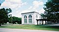
Former train station, now school district offices
-
Fort Ligonier
-
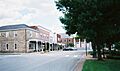
Ligonier's downtown with the Town Hall in the background.


See also
 In Spanish: Ligonier (Pensilvania) para niños
