Allegheny Mountain (Pennsylvania) facts for kids
Quick facts for kids Allegheny Mountain |
|
|---|---|
| Allegheny Ridge | |

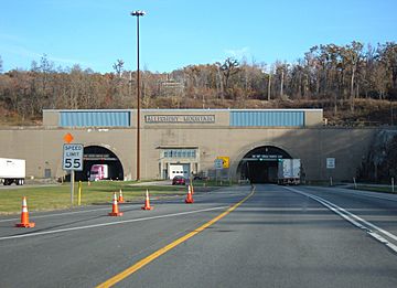
Allegheny Mountain Tunnel on the Pennsylvania Turnpike
|
|
| Highest point | |
| Peak | Grandview Summit (Eastern Continental Divide) |
| Elevation | 3,010.3 ft (917.5 m) |
| Geography | |
| Country | United States |
| Parent range | Ridge-and-Valley Appalachians of the Allegheny Mountains |
| Geology | |
| Orogeny | Alleghenian orogeny |
| Type of rock | Carboniferous |
Allegheny Mountain is a long, narrow mountain ridge in Pennsylvania, USA. It stretches from the south of Blue Knob (Pennsylvania) all the way to a low point near the Savage Mountain anticline. This ridge is part of the larger Ridge-and-Valley Appalachians mountain system.
The mountain is also known as Allegheny Ridge. It connects with Negro Mountain just north of the Cambria County line.
Contents
What is Allegheny Mountain?
Allegheny Mountain is a type of mountain called a stratigraphic ridge. This means it was formed by layers of rock that were folded and pushed up over millions of years. Over time, softer rocks wore away, leaving the harder rock layers to form the ridge we see today.
Where is it Located?
This mountain runs through several counties in Pennsylvania. These include Bedford, Cambria, and Somerset counties. It's a key part of the landscape in this region.
The Eastern Continental Divide
A very important feature of Allegheny Mountain is that the Eastern Continental Divide (ECD) runs along it. The ECD is like an invisible line across the continent. On one side, all the rain and melted snow eventually flow towards the Atlantic Ocean. On the other side, the water flows towards the Gulf of Mexico or the Great Lakes, which eventually connect to the Atlantic.
The ECD enters Allegheny Mountain south of a place called Fraziers Pass. It then follows the main ridge of the mountain southwest. It eventually leaves the mountain towards a lower area between the headwaters of Flaugherty and Wills Creeks. From there, the ECD continues onto the Savage Mountain anticline.
Mountain Heights and Crossings
Allegheny Mountain has different heights along its length. The highest point on the mountain is called Grandview Summit. It reaches an elevation of about 3,010 feet (917 meters). This summit is also located right on the Eastern Continental Divide.
Many important roads and paths cross Allegheny Mountain. These crossings often involve tunnels or passes through the ridge.
Important Crossings and Elevations
- Fraziers Pass: This area is about 3,010 feet (917 meters) high at Grandview Summit. To the west, the valley of the Stonycreek River is around 2,180 feet (664 meters). To the east, the Juniata River valley is much lower, around 1,100 feet (335 meters).
- US Route 30: This major road crosses the mountain.
- Pennsylvania Turnpike: A significant crossing is where the Pennsylvania Turnpike goes through the mountain. At this point, the summit is about 2,690 feet (820 meters) high. The famous Allegheny Mountain Tunnel allows cars to pass through the mountain here. The valley to the west, near the Stonycreek River, is about 2,220 feet (677 meters).
- Raystown Branch Juniata River: Near this river, there's a point where three different watersheds meet. This spot is about 2,889 feet (881 meters) high.
- Baltimore & Ohio Railroad: This historic railroad also crosses the mountain. Near Flaugherty Creek, the valley is around 1,940 feet (591 meters). The crossing point on the mountain is about 2,430 feet (741 meters) high.
The mountain's elevation changes as you travel along its length, creating various summits and lower points.
 | Ernest Everett Just |
 | Mary Jackson |
 | Emmett Chappelle |
 | Marie Maynard Daly |


