Forbes State Forest facts for kids
Quick facts for kids Forbes State Forest |
|
|---|---|
|
IUCN Category VI (Managed Resource Protected Area)
|
|
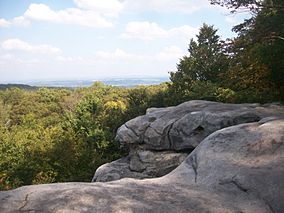
View of the surrounding forest from the Beam Rocks overlook.
|
|
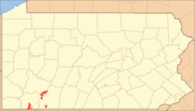
Location of Forbes State Forest in Pennsylvania
|
|
| Location | Pennsylvania, United States |
| Area | 50,000 acres (200 km2) |
| Elevation | 2,717 ft (828 m) |
| Governing body | Pennsylvania Department of Conservation and Natural Resources |
| Website | Forbes State Forest |
Forbes State Forest is a large public forest in Pennsylvania. It is managed by the Pennsylvania Bureau of Forestry. The main office is in Laughlintown, Westmoreland County. This forest is home to Mount Davis. Mount Davis is the highest point in all of Pennsylvania.
The forest is named after General John Forbes. It includes 20 separate pieces of land. These lands cover over 50,000 acres (20,234 hectares). They stretch across Fayette, Somerset, and Westmoreland Counties. The forest lands generally follow a big hill range called Laurel Ridge. This ridge is part of the Laurel Highlands.
Contents
History of Forbes State Forest
Forbes State Forest was created because Pennsylvania's forests were disappearing. This happened a lot in the late 1800s. People like Dr. Joseph Rothrock worried that the forests would not grow back. Lumber and iron companies had cut down most of the old trees. They often cut down every tree in an area. This left behind only dry branches and old stumps.
Sparks from passing steam locomotives (trains) often started wildfires. These fires stopped new trees from growing. Conservationists (people who protect nature) feared the forests would never recover. They wanted a new way to manage the forests. They asked the state to buy land from the companies. The companies were happy to sell because they had used up all the trees.
Changes began in 1895. Dr. Rothrock became the first commissioner of the Pennsylvania Department of Forests and Waters. This department is now called the Pennsylvania Department of Conservation and Natural Resources. In 1897, a law was passed. It allowed the state to buy land for "forest reservations." This was the start of the State Forest system we have today.
Visiting Forbes State Forest
The state has created 9 special areas for visitors. These include 6 State Parks and 3 State Forest Picnic Areas. The rest of the forest is mostly wild. It has many hiking trails. These trails are usually closed to cars. But they are great for hiking, cross-country skiing, hunting, and fishing.
Some parts of Forbes State Forest were once used for logging. Others were developed in the early 1900s. Now, these areas are being allowed to return to their natural state. This helps the forest become wild again.
Neighboring State Forests
Forbes State Forest is near other state forests.
- Clear Creek State Forest (north)
- Gallitzin State Forest (northeast)
- Buchanan State Forest (east)
Nearby State Parks
Several state parks are close to Forbes State Forest.
- Kooser State Park
- Laurel Hill State Park
- Laurel Mountain State Park
- Laurel Ridge State Park
- Laurel Summit State Park
- Linn Run State Park
- Ohiopyle State Park
Natural Features and Wildlife
Forbes State Forest is part of the Appalachian mixed mesophytic forests area. This means it has a mix of different kinds of trees. The forest also has many interesting natural spots.
Roaring Run Natural Area
This area covers 3,070 acres (1,242 hectares). Pennsylvania bought it in 1975. It was once logged and developed. Now, it is growing back into a forest. It has many mixed trees that are in their second or third growth stage. Roaring Run is a stream that flows into Indian Creek. Indian Creek then flows into the Youghiogheny River.
Mount Davis Natural Area
Mount Davis is the highest point in Pennsylvania. Water from this area flows into the Casselman River. This river is part of the huge Mississippi River watershed. This means its water eventually reaches the Mississippi River.
One cool thing here is the small stone rings on the ground. These rings form because of something called frost heaving. When the ground freezes and thaws, it pushes up softer patches of earth. Then, natural erosion makes stones slide down. They form ring-like patterns at the bottom of these pushed-up areas.
Spruce Flats Wildlife Management Area
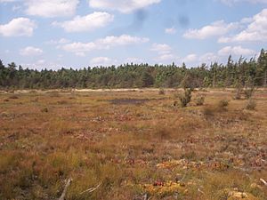
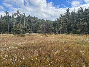
This wildlife area covers 305 acres (123 hectares). Its main feature is the 28-acre (11-hectare) Spruce Flats Bog. A bog is a type of swamp. This bog formed in a natural dip on top of Laurel Ridge.
The area used to be open water, then slowly became a forest. But in the early 1900s, this process was reversed. Trees were cut down, and fires burned the forest floor. This turned the area back into a bog. Now, it is slowly changing back into a forest again. The bog is home to many plants. These include cranberry, pitcher plant, sundew, and cotton grass.
 | Laphonza Butler |
 | Daisy Bates |
 | Elizabeth Piper Ensley |


