Laurel Ridge State Park facts for kids
Quick facts for kids Laurel Ridge State Park |
|
|---|---|
|
IUCN Category III (Natural Monument)
|
|
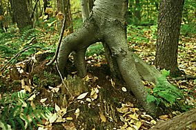
One tree grows from the rotting stump of another at Laurel Ridge State Park
|
|
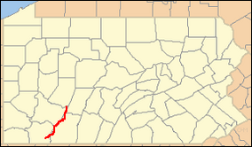
Location of Laurel Ridge State Park in Pennsylvania
|
|
| Location | Pennsylvania, United States |
| Area | 13,625 acres (55.14 km2) |
| Elevation | 2,759 ft (841 m) |
| Established | 1967 |
| Named for | Laurel Ridge |
| Governing body | Pennsylvania Department of Conservation and Natural Resources |
| Website | Laurel Ridge State Park |
Laurel Ridge State Park is a huge park in Pennsylvania, covering 13,625-acre (5,514 ha). It stretches across four different counties: Cambria, Fayette, Somerset, and Westmoreland. The park is famous for the 70-mile (110 km) Laurel Highlands Hiking Trail. This long trail goes all the way from the Youghiogheny River at Ohiopyle to the Conemaugh Gorge near Johnstown. The park was officially approved in 1967, and work on the hiking trail began in 1970.
Contents
The Laurel Highlands Hiking Trail
The Laurel Highlands Hiking Trail is 70 miles (110 km) long. It starts at Ohiopyle State Park and finishes near Johnstown at the Conemaugh Gorge. This amazing trail winds through many different types of land. You'll walk through state forests, other state parks, special game lands, and even some private properties.
The trail is open all year round, so you can explore it in any season. To help you stay on track, the main trail is marked with bright yellow blazes. These are special painted marks on trees or rocks. If you see blue blazes, those are connector trails. These shorter paths lead you from the main trail to parking areas or places where you can rest.
Large wooden signs are placed at every major road crossing. These signs help you know where you are. There are six parking lots located at these road crossings, which are great starting points for your hike. Some of these spots even have access to drinking water.
Shelter Areas for Hikers
Along the Laurel Highlands Hiking Trail, there are eight special areas where hikers can stay overnight. These shelter areas are spaced out, usually every 6 miles (9.7 km) to 10 miles (16 km) along the trail.
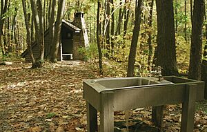
Each shelter area has five "Adirondack style" shelters. These are simple, open-front structures that offer protection from the weather. There are also two outhouses at each stop for restrooms. You'll also find a water supply, though it might not always be drinking water.
If you prefer to sleep in a tent, there's plenty of space for up to 30 tents at each stop. Firewood is also provided, so you can have a campfire. If you plan to use these shelters, you need to make a reservation with the park staff before you start your hike. There is a small fee to use the shelters.
Exploring the Trail's Path
The Laurel Highlands Hiking Trail starts its journey from the southern end in Ohiopyle State Park. For the first 6 miles (9.7 km), the trail heads east and runs next to the Youghiogheny River. After this, you'll reach the first overnight shelter area. Here, the trail turns northeast.
Around 7 miles (11 km), the trail leaves Ohiopyle State Park and enters Pennsylvania State Game Lands No. 111. As you continue, the trail enters Laurel Ridge State Park itself for the first time. It keeps going northeast. Just past 17 miles (27 km), the trail turns north and crosses back into Fayette County, where you'll find the second overnight shelter.
The trail generally moves northeast, passing the Laurel Ridge State Park office. It then enters Forbes State Forest. After a short time, it returns to Somerset County and passes the third overnight shelter area. The trail sometimes follows the border between Laurel Ridge State Park and Forbes State Forest. It also crosses some private land. You'll pass near the borough of Seven Springs and the Seven Springs Mountain Resort.
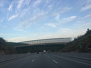
The trail then crosses into Westmoreland County and enters the state forest and Laurel Ridge State Park again. Later, it crosses back into Somerset County and passes the fourth overnight shelter area. It runs west of Kooser State Park and crosses the Pennsylvania Turnpike (Interstate 70/76). There's a special pedestrian bridge over the turnpike that was closed for a while but reopened in 2012. This part of the trail goes through the state forest and smaller parts of Laurel Ridge State Park.
Around 38 miles (61 km), the trail fully enters Laurel Ridge State Park. It briefly crosses into Westmoreland County before returning to Somerset County. Here, you'll find the fifth overnight shelter. The trail then reaches Laurel Summit State Park at 39 miles (63 km).
Continuing through the state forest, the trail passes east of Linn Run and Laurel Mountain state parks. It crosses U.S. Route 30 just before 46 miles (74 km) and reaches the sixth overnight shelter. The trail stays within the state park for a while, then enters State Game Lands No. 42.
The trail moves between Laurel Ridge State Park and State Game Lands, and even crosses into private land for a bit. Before 57 miles (92 km), it enters another part of the state park. Here, it crosses Pennsylvania Route 271, and you'll find the seventh overnight shelter. The trail then enters State Game Lands No. 42 again, and then Cambria County.
The trail continues through State Game Lands No. 42 and crosses back into Westmoreland County. Around 60 miles (97 km), it enters St. Clair Township in Westmoreland County, crossing into Cambria County a couple of times. Finally, it leaves the State Game Lands and enters Laurel Ridge State Park for the last time before 63 miles (101 km).
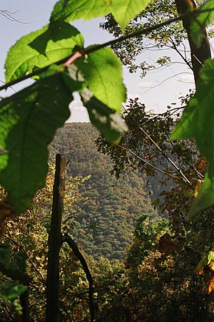
The eighth and final overnight shelter is past 64 miles (103 km). The trail continues northeast until it turns north just before 67 miles (108 km), crossing into Westmoreland County. The trail now runs next to the Conemaugh River, offering beautiful views of the river valley. The trail finally ends at 70 miles (110 km).
Park Environment
Laurel Ridge State Park, along with its hiking trail, is located in a special natural area called the Appalachian mixed mesophytic forests ecoregion. This means the park is home to a mix of different types of trees and plants that are common in the Appalachian Mountains.
Other Fun Activities
Besides hiking, Laurel Ridge State Park offers other activities for visitors. You can go hunting, cross-country skiing, and snowmobiling in certain areas.
Hunting
Hunting is allowed in most parts of Laurel Ridge State Park. Some of the animals you might find here include ruffed grouse, turkey, and white-tailed deer. However, hunting groundhogs is not allowed. Hunters must always follow the rules set by the Pennsylvania Game Commission.
Winter Sports
During the winter months, the park transforms into a snowy playground. There are 35 miles (56 km) of trails perfect for cross-country skiing. If you enjoy faster adventures, there are over 70 miles (110 km) of trails open for snowmobiling.
Nearby State Parks
If you're looking to explore more nature, several other state parks are within 30 miles (48 km) of Laurel Ridge State Park:
- Blue Knob State Park (Bedford County)
- Keystone State Park (Westmoreland County)
- Kooser State Park (Somerset County)
- Laurel Hill State Park (Somerset County)
- Laurel Mountain State Park (Westmoreland County)
- Laurel Summit State Park (Westmoreland County)
- Linn Run State Park (Westmoreland County)
- Ohiopyle State Park (Fayette County)
- Yellow Creek State Park (Indiana County)
 | Sharif Bey |
 | Hale Woodruff |
 | Richmond Barthé |
 | Purvis Young |


