Bremo Bluff, Virginia facts for kids
Quick facts for kids
Bremo Bluff
|
|
|---|---|

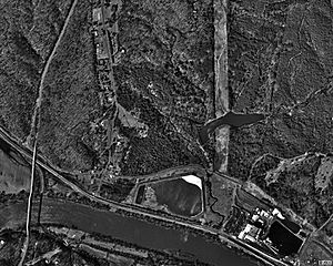
Aerial photo of Bremo Bluff in 1994
|
|
| Country | United States |
| State | Virginia |
| County | Fluvanna |
| Land patent | March 6, 1636 |
| Elevation | 452 ft (138 m) |
| Population
(2010)
|
|
| • Total | 656 |
| Time zone | UTC−5 (Eastern (EST)) |
| • Summer (DST) | UTC−4 (EDT) |
| ZIP codes |
23022
|
| Area code(s) | 434 |
Bremo Bluff is a small community in Fluvanna County, Virginia. It is located right by the James River. The Cocke family started this community way back in 1636. During the American Civil War, General Robert E. Lee's family even found a safe place here. Bremo Bluff is also known for the Bremo Power Station, which used to make a lot of electricity for the area.
Contents
Bremo Bluff's Early History
The story of Bremo Bluff began with the Cocke family. Richard Cocke, who came from England, was given a large piece of land on March 6, 1636. This land was about 3,000 acres (12 km²) along the James River. The Cocke family named their new home "Bremo" after their old family home in the United Kingdom.
Around 1725, two brothers, Benjamin and Richard Cocke, worked to develop the Bremo Bluff area. Later, in 1808, John Hartwell Cocke II started building a big estate with three houses, also called Bremo. He helped create the James River and Kanawha Canal to make river travel easier. This canal and a boat wharf (a place where boats dock) became very important for the local economy by the 1850s. However, floods and the American Civil War later ended this busy time.
A Safe Place During the Civil War
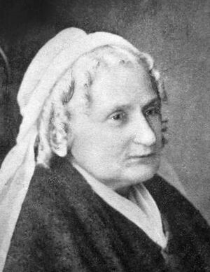
Mary Anna Custis Lee, who was the wife of Confederate General Robert E. Lee, often stayed in the Fluvanna County area during the Civil War. She found it a safe place away from the fighting. She spent time at the Bremo Plantation. Her family friend, Dr. Cary Charles Cocke, owned the plantation. He even had a special bed made for her because she had rheumatoid arthritis, a condition that affects joints.
Mary Anna Custis Lee was usually with her son Rob and her daughters Agnes and Mildred. Even though it was against the law at the time in the Confederate States of America, Mary Anna Custis Lee and Dr. Cocke taught enslaved people to read. They did this because they were against slavery. After the war, in November 1865, the Lee family moved to Lexington, Virginia. Robert E. Lee became the president of Washington College there. Mary Anna Custis Lee visited the area one more time in 1870, just a few months before her husband passed away.
Industrial Growth and Power
After the Civil War, in 1880, the old canal route was used to build a new railway. This railway was called the Richmond and Allegheny Railroad. Bremo Bluff quickly became one of the busiest stops for trains carrying people and goods. By 1918, four trains stopped in the town every day.
In 1931, the Virginia Electric & Power Company built a coal-fired power station at Bremo Bluff. This power station was located along the James River. The railway line is now owned by CSX Transportation. It connects to the Buckingham Branch Railroad, which brings coal to the power station.
The Bremo Power Station was run by Dominion Energy. It had a large generator that started working in 1950, and an even bigger one in 1958. The original system was shut down in 1972. The power station could produce over 240 megawatts of electricity. This power was sent to an area of about 30,000 square miles (78,000 km²). In 2008, it was decided that the plant would switch to using natural gas. The power station was planned to be completely taken down by the end of 2022.
Local Landmarks and Sights
You can reach Bremo Bluff from U.S. Route 15. It is located across the James River from Buckingham County, Virginia. The oldest part of the village, called "Bachelor's Quarters," is along Route 657.
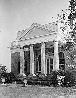
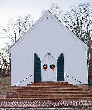
West of the village, you'll find the Bremo Historic District. This area includes the Cocke family plantation and is a very important historical site. The main house at the plantation was designed by John Hartwell Cocke. He was inspired by the Palladian architecture style of Thomas Jefferson. The builder, John Neilson, also worked with Jefferson on Monticello. The estate once had the Bremo Slave Chapel. This chapel has since been moved to the center of Bremo Bluff village. It is now listed on the National Register of Historic Places.
Other important places listed on the National Register of Historic Places in the area include Glen Arvon and Rivanna Farm.
Community Information
Bremo Bluff is part of the Charlottesville metropolitan area. In 2010, the local zip code 23022 had 656 people living there. The average age for men was 40.8 years, and for women, it was 41.8 years. The average home value was $56,000, and the average household income was $54,396 per year. About 129 people worked in 14 local businesses, earning a total of $6,243,000 in 2010.
Climate in Bremo Bluff
Bremo Bluff has a climate with warm temperatures and rain spread out throughout the year. This type of climate is called "Humid subtropical" (Cfa).
| Climate data for Bremo Bluff, Virginia(1991-2020 Normals) | |||||||||||||
|---|---|---|---|---|---|---|---|---|---|---|---|---|---|
| Month | Jan | Feb | Mar | Apr | May | Jun | Jul | Aug | Sep | Oct | Nov | Dec | Year |
| Mean daily maximum °C (°F) | 9.4 (48.9) |
11.6 (52.8) |
16.3 (61.4) |
22.6 (72.6) |
26.7 (80.1) |
30.9 (87.6) |
33.2 (91.7) |
32.3 (90.1) |
28.6 (83.5) |
22.7 (72.9) |
16.5 (61.7) |
11.2 (52.2) |
21.8 (71.3) |
| Mean daily minimum °C (°F) | −5.5 (22.1) |
−4.5 (23.9) |
−0.9 (30.3) |
4.3 (39.8) |
9.9 (49.9) |
14.7 (58.5) |
17.4 (63.3) |
16.6 (61.9) |
12.4 (54.4) |
5.2 (41.3) |
−0.8 (30.6) |
−3.8 (25.2) |
5.4 (41.8) |
| Average precipitation mm (inches) | 84 (3.30) |
71 (2.79) |
102 (4.01) |
83 (3.28) |
123 (4.86) |
109 (4.28) |
130 (5.13) |
97 (3.81) |
105 (4.15) |
101 (3.99) |
92 (3.63) |
92 (3.62) |
1,189 (46.85) |
| Source: NOAA | |||||||||||||
 | Jessica Watkins |
 | Robert Henry Lawrence Jr. |
 | Mae Jemison |
 | Sian Proctor |
 | Guion Bluford |


