
James River Bridge facts for kids
Quick facts for kids James River Bridge |
|
|---|---|

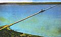
The 1928 bridge, replaced from 1975 to 1982
|
|
| Coordinates | 36°59′28″N 76°29′01″W / 36.9910°N 76.4836°W |
| Carries | 4 lanes of |
| Crosses | James River |
| Locale | Isle of Wight County, VA to Newport News, VA |
| Maintained by | Virginia DOT |
| ID number | 10364 |
| Characteristics | |
| Design | steel lift bridge |
| Total length | 7.0714 km (4.3940 mi) |
| Width | 20.8 m (68.2 ft) |
| Longest span | 126.5 m (415.0 ft) |
| Clearance above | 4.87 m (16.0 ft) |
| Clearance below | 44.1 m (145 ft) open 18.2 m (59.7 ft) closed |
| History | |
| Opened | 1982 |
 |
|
The James River Bridge (JRB) is a four-lane bridge that crosses the James River in Virginia. It's a special type of bridge called a lift bridge. This means a part of it can go up and down to let tall ships pass underneath.
The bridge is owned and managed by the Virginia Department of Transportation. It carries three important roads: U.S. Route 17, U.S. Route 258, and State Route 32. The bridge connects Newport News on the Virginia Peninsula with Isle of Wight County. It's the easternmost bridge crossing the James River without a tunnel part.
When the first James River Bridge was finished in 1928, it was the longest bridge in the world over water. It was about 7 kilometers (4.5 miles) long. The original bridge had two lanes. It was replaced between 1975 and 1982 with a wider, four-lane bridge. This new bridge could handle many more cars. In 2005, about 30,000 vehicles used the bridge every day.
Contents
Exploring the James River Bridge Today
The James River Bridge is a very important connection for drivers in Virginia. It helps people travel between different parts of the state.
How Traffic Approaches the Bridge
On the Newport News side, cars get onto the bridge using a special road design called a partial cloverleaf interchange. Here, Mercury Boulevard (which carries US 17, US 258, and SR 32) goes over Warwick Boulevard (US 60). After passing an intersection with River Road and the entrance to Huntington Park, the four-lane bridge begins.
The Lifting Part of the Bridge
A key feature of the bridge is its lift span. This is the part that moves up and down. It's about 126.5 meters (415 feet) long. When the lift span is raised, ships have 44.1 meters (145 feet) of space to pass under. When it's lowered, there's 18.2 meters (59.7 feet) of space. This lifting ability allows large ocean-going ships to travel to ports further up the river, like in Hopewell and Richmond. The lift span is located about a quarter of the way along the bridge's total length of 7.07 kilometers (4.39 miles).
.jpg)
Where the Bridge Connects
On the Isle of Wight County side, the road becomes Carrollton Boulevard. After several intersections, US 258 and SR 32 turn west towards State Route 10 at Benns Church. Meanwhile, US 17 curves southeast towards Portsmouth.
Other River Crossings Nearby
The closest crossing upstream from the James River Bridge is the Jamestown Ferry (State Route 31). The next permanent bridge upstream is the 1966 Benjamin Harrison Bridge (State Route 156) near Hopewell. When the first James River Bridge opened in 1928, the next bridge upstream was the 1913 Mayo Bridge in Richmond.
Downstream from the James River Bridge, there are two bridge-tunnels that cross Hampton Roads. These are the 1992 Monitor-Merrimac Bridge-Tunnel (Interstate 664) and the 1957 Hampton Roads Bridge-Tunnel (Interstate 64/US 60). These bridge-tunnels are important for military reasons.
Rules for Using the Bridge
For safety reasons, Bicycles, mopeds, and pedestrians are not allowed on the James River Bridge. The closest place for them to cross the James River is the Jamestown Ferry, which is about 40 kilometers (25 miles) upstream. This ban was put in place in 1978 because of heavy traffic and no sidewalks on the bridge. When the new bridge was built, it also didn't have sidewalks, so the ban continued for everyone's safety.
A Look Back: History of the James River Bridge
The story of the James River Bridge began with a private company.
Building the First Bridge System
A private company called the James River Bridge Corporation was given permission to build a system of bridges. This system included the main bridge across the James River, plus two smaller toll bridges over Chuckatuck Creek and the Nansemond River. It also included the roads leading to these bridges.
On the Newport News side, the bridge simply connected to U.S. Route 60. However, on the Isle of Wight County side, a larger system of approach roads and the two smaller bridges were built. This system helped connect traffic coming off the main bridge to other important roads in the area.
Opening Day in 1928
The first James River Bridge cost $5.2 million to build. It officially opened on November 17, 1928. The opening was quite special: U.S. President Calvin Coolidge was in Washington, D.C., and he pressed a button in the White House to send an electric signal. This signal caused the lift span of the bridge to lower into place, marking its grand opening.
Before this bridge, people had to use ferries to cross Hampton Roads. The new bridge gave drivers a fixed way to cross. The original bridge was quite narrow, with a roadway only 6 meters (20 feet) wide. Its railings were also much less strong than those on modern bridges. The main lift span was 90 meters (300 feet) long. The two smaller bridges in the system also had parts that could open, called bascule spans, which were 34 meters (110 feet) long.
Tolls and Ownership Changes
For many years, drivers had to pay a fee, called a toll, to cross the James River Bridge.
The State Takes Over
By 1933, the state of Virginia started thinking about taking over the bridge. The private company that owned the bridge didn't get as much traffic as they expected, and they ended up going bankrupt. A group of bondholders, led by a local businessman, bought the company. The new owners raised the tolls, which made many local people unhappy.
In 1940, the state of Virginia decided to buy the entire James River Bridge System. On September 30, 1949, the state bought the three bridges and their approach roads for $5.6 million.
Toll Increases and Removal
In 1955, the state actually doubled the tolls. For cars, a round trip cost $1.80, and for trucks, it was $4.00 or more. This money was used to pay for repairs, new toll booths, and a new system for collecting tolls. The toll collection points were combined from three to two. This meant that the Crittenden Bridge became free for local traffic.
A local businessman, J.W. Luter, Jr., who owned the Smithfield Packing Company, found a way to avoid the high tolls. He sent his trucks over a smaller, cheaper bridge owned by someone else. This practice is sometimes called "shunpiking."
Eventually, the tolls were lowered to 10 cents per axle. Then, on June 3, 1976, all tolls were removed from the James River Bridge. The state had paid off the remaining money it owed for the bridge. At the same time, tolls were also removed from the Hampton Roads Bridge-Tunnel, the Coleman Bridge, and the Robert O. Norris Bridge. Many people felt that removing these tolls was a big step forward for the development of the area.
The old building where tolls were collected was used for maintenance workers and police until 2002.
A New Bridge for More Traffic: 1975-1982
As traffic grew, a new, wider bridge was needed.

Building the Replacement Bridge
Construction on the new four-lane lift bridge began in 1975 and was finished in stages by 1982. During this time, the two southbound lanes of the new bridge were built first. These lanes were then used for northbound traffic. The old bridge continued to carry two lanes of southbound traffic. Once the northbound lanes of the new bridge were ready, the old bridge was taken down.
The James River Pier
However, a 1.2-kilometer (0.75-mile) section of the old bridge on the Newport News side was kept. This part was turned into a fishing pier. It is now known as the James River Pier and is the longest fishing pier on the East Coast. Over time, the metal beams supporting the pier became very rusty. So, in 2015, the James River Pier was taken down and rebuilt using stronger concrete materials.
Images for kids
-
The 1928 bridge, replaced from 1975 to 1982
-

Map of the James River Bridge
-
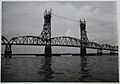
The original James River Bridge, circa 1960.
.jpg)
