Wayne County, West Virginia facts for kids
Quick facts for kids
Wayne County
|
||
|---|---|---|
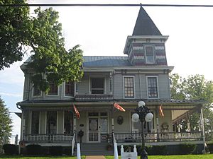
Joseph S. Miller House at Kenova.
|
||
|
||
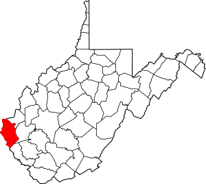
Location within the U.S. state of West Virginia
|
||
 West Virginia's location within the U.S. |
||
| Country | ||
| State | ||
| Founded | January 18, 1842 | |
| Named for | Anthony Wayne | |
| Seat | Wayne | |
| Largest city | Kenova | |
| Area | ||
| • Total | 512 sq mi (1,330 km2) | |
| • Land | 506 sq mi (1,310 km2) | |
| • Water | 6.1 sq mi (16 km2) 1.2%% | |
| Population
(2020)
|
||
| • Total | 38,982 | |
| • Estimate
(2021)
|
38,498 |
|
| • Density | 76.14/sq mi (29.397/km2) | |
| Time zone | UTC−5 (Eastern) | |
| • Summer (DST) | UTC−4 (EDT) | |
| Congressional district | 1st | |
Wayne County is the county farthest west in West Virginia, a state in the United States. In 2020, about 38,982 people lived there. The main town, or county seat, is Wayne.
The county was created in 1842. It was named after General "Mad" Anthony Wayne. Wayne County is part of a larger area called the Huntington–Ashland Metropolitan Statistical Area. This means it's connected to nearby cities like Huntington, West Virginia, and Ashland, Kentucky.
Contents
History of Wayne County
Wayne County, West Virginia, was first part of Virginia. It was known as Wayne County, Virginia. It was formed in 1842 from a piece of Cabell County. The county got its name from General "Mad" Anthony Wayne, a famous military leader.
Early Settlers and Safety
For a long time, there were no European settlers in this area. This was because of the danger of attacks from Native American groups. The area became safer for settlers after 1794. This was when General "Mad" Anthony Wayne defeated the Shawnee at the Battle of Fallen Timbers.
The first permanent European settlers arrived around the year 1800. At that time, this land was part of Kanawha County. Most of these early settlers were farmers. They grew their own food and raised sheep for wool to make clothes. They also built their homes and tools from the surrounding forests.
A few trading posts helped pioneers get things they couldn't make. Later, grist mills were built in places like Wayne and Lavalette. These mills ground their corn into meal and their wheat into flour.
Becoming Part of West Virginia
On June 20, 1863, during the Civil War, Wayne County became part of the new state of West Virginia. West Virginia was formed from fifty counties that separated from Virginia.
Later that year, counties were divided into civil townships. This was meant to help local governments. But it didn't work well in rural areas. So, in 1872, townships became magisterial districts. Wayne County was split into five districts: Butler, Ceredo, Grant, Lincoln, and Union. A sixth district, Stonewall, was added in 1878. In the 1920s, Westmoreland became the seventh district. Some districts, like Grant and Lincoln, were later removed.
Geography of Wayne County
Wayne County covers a total area of about 512 square miles. Most of this is land, about 506 square miles. The rest, about 6.1 square miles, is water.
Rivers and Lakes
Wayne County has several important waterways:
Major Roads and Highways
Several main roads pass through Wayne County, connecting it to other areas:
- Interstate 64
 I‑73 (future road)
 I‑74 (future road)
- U.S. Route 52
- U.S. Route 60
- West Virginia Route 37
- West Virginia Route 152
- West Virginia Route 75
Neighboring Counties
Wayne County shares borders with several other counties:
- Lawrence County, Ohio (to the north)
- Cabell County (to the northeast)
- Lincoln County (to the east)
- Mingo County (to the southeast)
- Martin County, Kentucky (to the south)
- Lawrence County, Kentucky (to the west)
- Boyd County, Kentucky (to the northwest)
Wayne County is special because it borders two counties with the same name, but in different states: Lawrence County, Ohio, and Lawrence County, Kentucky.
Population and People
| Historical population | |||
|---|---|---|---|
| Census | Pop. | %± | |
| 1850 | 4,760 | — | |
| 1860 | 6,747 | 41.7% | |
| 1870 | 7,852 | 16.4% | |
| 1880 | 14,739 | 87.7% | |
| 1890 | 18,652 | 26.5% | |
| 1900 | 23,619 | 26.6% | |
| 1910 | 24,081 | 2.0% | |
| 1920 | 26,012 | 8.0% | |
| 1930 | 31,206 | 20.0% | |
| 1940 | 35,566 | 14.0% | |
| 1950 | 38,696 | 8.8% | |
| 1960 | 38,977 | 0.7% | |
| 1970 | 37,581 | −3.6% | |
| 1980 | 46,021 | 22.5% | |
| 1990 | 41,636 | −9.5% | |
| 2000 | 42,903 | 3.0% | |
| 2010 | 42,481 | −1.0% | |
| 2020 | 38,982 | −8.2% | |
| 2021 (est.) | 38,498 | −9.4% | |
| U.S. Decennial Census 1790–1960 1900–1990 1990–2000 2010–2020 |
|||
2010 Census Information
In 2010, there were 42,481 people living in Wayne County. These people lived in 17,347 households, with 12,128 of them being families. The county had about 84 people per square mile.
Most of the people in the county (98.6%) were white. Small percentages were American Indian, Black, Asian, or from other backgrounds. About 0.5% of the population was of Hispanic or Latino origin.
Many people in Wayne County have Irish, English, American, or German ancestry.
About 30.9% of households had children under 18. The average household had 2.43 people, and families had about 2.92 people. The average age of people in the county was 41.3 years old.
The median income for a household was $35,079. For families, it was $44,886. About 20.2% of all people in the county lived below the poverty line. This included 23.2% of those under 18.
Transportation
Railways
Trains play a role in transportation in Wayne County. Some of the railway lines include:
- Norfolk Southern Railway's former N&W Kenova District
- CSX Transportation's former C&O Kanawha Sub
- Kanawha River Terminal Railroad
Air Travel
The main airport for the Huntington–Ashland area is the public Tri-State Airport. It is located in Wayne County, just south of Interstate 64. You can reach the airport from Interstate 64 by taking Exit 1. Airlines like Allegiant Air and American Airlines offer flights from this airport.
Notable People from Wayne County
Many interesting people have come from Wayne County:
- Mariko Elizabeth Alley: A Filipino-American soccer player who plays for the Philippines women's national team.
- Jeff Baldwin: A former Major League Baseball player.
- Derrick Evans: A former member of the West Virginia House of Delegates.
- Don Robinson: A former Major League Baseball pitcher.
- Michael W. Smith: A well-known musician, pastor, and actor.
- Brad D. Smith: The former President and CEO of Intuit, Inc., a big software company.
- Blaze Starr: An American burlesque star.
- Carmi Thompson: A politician who served as Speaker of the Ohio House of Representatives and Ohio Secretary of State. He was also Treasurer of the United States.
Communities in Wayne County
Wayne County has several different types of communities:
Cities
- Huntington (most of this city is in Cabell County)
- Kenova
Towns
Magisterial Districts
These are areas within the county used for local government.
Current Districts
- Butler
- Ceredo
- Stonewall
- Union
- Westmoreland
Historic Districts
- Grant
- Lincoln
Census-Designated Places
These are areas identified by the census bureau but are not officially incorporated as cities or towns.
Unincorporated Communities
These are smaller communities that are not officially part of a city or town.
- Ardel
- Armilda
- Bethesda
- Booton
- Bowen
- Brabant
- Buffalo Creek
- Centerville
- Coleman
- Cove Gap
- Crockett
- Cyrus
- Dickson
- Doane
- Dunlow
- East Lynn
- Echo
- Effie
- Elmwood
- Ferguson
- Fleming
- Genoa
- Gilkerson
- Girard
- Glenhayes
- Grandview Gardens
- Hidden Valley
- Hubbardstown
- Mineral Springs
- Missouri Branch
- Neal
- Nestlow
- Oakview Heights
- Quaker
- Radnor
- Saltpetre
- Shoals
- Sidney
- Stepptown
- Stiltner (no longer exists)
- Stonecoal
- Sweet Run
- Tripp
- Webb
- Wilsondale
- Winslow
Wayne County in Books
Several books have stories that take place in Wayne County:
- Last Train to Dunlow by Kay and Jack Dickinson.
- On the Trail of the Powhatan Arrow by Kay and Jack Dickinson.
- Discovering Lavalette by Gina Simmons.
- Pioneers, Rebels and Wolves by Robert Thompson
- Climbing Trout's Hill by Robert Thompson
- East Lynn Booming by Robert Thompson.
- Images Of East Lynn by Robert Thompson
- Fear No Man by Robert Thompson
- Aging Wonders by Robert Thompson
- Few Among The Mountains by Robert Thompson
- Crum by Lee Maynard
- Protectors of the Ohio Valley by Matthew A. Perry
Images for kids
See also
 In Spanish: Condado de Wayne (Virginia Occidental) para niños
 | Kyle Baker |
 | Joseph Yoakum |
 | Laura Wheeler Waring |
 | Henry Ossawa Tanner |


