East Lynn, West Virginia facts for kids
Quick facts for kids
East Lynn
|
|
|---|---|

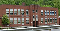
Elementary school
|
|
| Country | United States |
| State | West Virginia |
| County | Wayne |
| Time zone | UTC-5 (Eastern (EST)) |
| • Summer (DST) | UTC-4 (EDT) |
| GNIS feature ID | 1538508 |
| Settled: | ca 1866 |
|---|---|
| Incorporated: | 1908 |
| Charter Abandoned: | 1917 |
East Lynn is an unincorporated community located in Wayne County, West Virginia, in the United States. It sits along the banks of Twelvepole Creek, about eight miles south of the county seat, Wayne. An "unincorporated community" means it's a place where people live, but it doesn't have its own local government like a city or town with a mayor and city council. East Lynn was also known as Mouth of Little Lynn for a time.
East Lynn is part of a larger area called the Huntington-Ashland Metropolitan Statistical Area (MSA). This is a way to group nearby cities and towns that are connected by things like jobs and transportation. In 2010, this larger area had about 287,702 people.
What is the history of East Lynn?
East Lynn started as a small trading spot known as Twin Creek. Over time, it grew into a "coal town," which means its growth was mainly due to coal mining in the area.
In 1868, a post office was set up, and the community became known as Adkins Mills. A railroad company, the Big Sandy, East Lynn & Guyan Railroad, was formed in 1903. This railroad later joined with the Norfolk and Western railway in 1908.
Also in 1908, East Lynn officially became an incorporated town. This meant it had its own local government. During the 1910s, East Lynn continued to grow. It even had three movie theaters, doctors, lawyers, and a detective agency at different times!
However, in the late 1910s, the people living there decided to give up the town's official charter. This made East Lynn an unincorporated community again. Much of the town was destroyed by a big fire in November 1919. East Lynn was rebuilt, but it burned down again in February 1955.
In the 1960s, the coal mines in the area closed down, and the railroad left. This caused the town to become run-down. A large lake, the East Lynn Lake, was created in the 1960s by the Army Corps of Engineers. As of 2005, a company called Rockspring Development reopened a mine nearby, but it hasn't led to new growth for East Lynn itself.
What is the population of East Lynn?
East Lynn is part of the Huntington-Ashland, WV-KY-OH, Metropolitan Statistical Area (MSA). This larger area had a population of about 288,649 people in the year 2000.
 | Anna J. Cooper |
 | Mary McLeod Bethune |
 | Lillie Mae Bradford |


