Lincoln County, West Virginia facts for kids
Quick facts for kids
Lincoln County
|
|
|---|---|
|
County
|
|

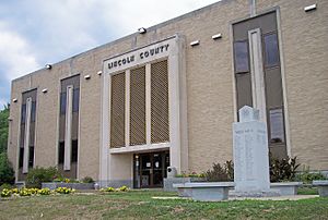
The Lincoln County Courthouse in Hamlin in 2007
|
|

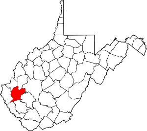
Location within the U.S. state of West Virginia
|
|
 West Virginia's location within the U.S. |
|
| Country | |
| State | |
| Founded | February 23, 1867 |
| Named for | Abraham Lincoln |
| Seat | Hamlin |
| Largest town | Hamlin |
| Area | |
| • Total | 439 sq mi (1,140 km2) |
| • Land | 437 sq mi (1,130 km2) |
| • Water | 1.6 sq mi (4 km2) 0.4%% |
| Population
(2020)
|
|
| • Total | 20,463 |
| • Estimate
(2021)
|
20,126 |
| • Density | 46.61/sq mi (17.997/km2) |
| Time zone | UTC−5 (Eastern) |
| • Summer (DST) | UTC−4 (EDT) |
| Congressional district | 1st |
Lincoln County is a county in the state of West Virginia. In 2020, about 20,463 people lived there. The main town and county seat is Hamlin. Lincoln County was created in 1867 and was named after Abraham Lincoln, a famous U.S. president.
Lincoln County is also part of a larger area called the Huntington-Ashland, WV-KY-OH Metropolitan Statistical Area. This means it's connected to the bigger cities of Huntington, Ashland, and nearby areas.
Contents
History of Lincoln County
Lincoln County was officially formed on February 23, 1867. This happened after the West Virginia Legislature decided to create it from parts of other counties. These included Boone, Cabell, Kanawha, and Putnam counties.
A few years later, in 1869, the county's borders changed a bit. It gave back some land to Putnam County. It also gained land from Logan County and Wayne County. Lincoln County is one of only five counties created in West Virginia after the Civil War. The town of Hamlin, which is the county seat, was started earlier in 1853.
The first European settlers in what is now Lincoln County were the McComas family. Jesse, John, David, William, and Moses McComas arrived in 1799. They planted about 20 acres (81,000 square meters) of corn near where West Hamlin is today. This was the first corn grown in the area. They went back to eastern Virginia to get their families later that year. They first came alone to check if the land was safe and good for farming.
Soon after, John Lucas, William Hinch, and John Johnson joined the McComas family. They built cabins around 1800. Around 1804, William Wirt Brumfield settled near the mouth of Big Ugly Creek.
During the Civil War, people in Lincoln County had mixed feelings. Some supported the Union, and some supported the Confederacy. There were a few small fights in the county, mainly around the Mud River.
After the war, the main industry in Lincoln County became timbering, which is cutting down trees for wood. The county also became well-known for growing tobacco. In the early 1900s, the county also had a big boom in natural gas production.
In 1863, West Virginia counties were divided into smaller areas called civil townships. This was meant to help local governments. But it didn't work well in rural areas. So, in 1872, these townships became magisterial districts. When Lincoln County was formed, it had seven townships: Carroll, Duval, Harts Creek, Jefferson, Sheridan, Union, and Washington. In 1871, Laurel Hill Township was added. The next year, all eight became magisterial districts. These districts stayed mostly the same for a long time. In recent years, they were combined into three new districts: District 1, District 2, and District 3.
Geography of Lincoln County
The United States Census Bureau says that Lincoln County covers a total area of about 439 square miles (1,137 square kilometers). Most of this, 437 square miles (1,132 square kilometers), is land. Only a small part, about 1.6 square miles (4.1 square kilometers), is water.
Major Roads
 U.S. Highway 119
 West Virginia Route 3
 West Virginia Route 10
 West Virginia Route 34
 West Virginia Route 37
 West Virginia Route 214
Neighboring Counties
Lincoln County shares its borders with several other counties:
- Putnam County (to the north)
- Kanawha County (to the northeast)
- Boone County (to the southeast)
- Logan County (to the south)
- Mingo County (to the southwest)
- Wayne County (to the west)
- Cabell County (to the northwest)
People of Lincoln County
| Historical population | |||
|---|---|---|---|
| Census | Pop. | %± | |
| 1870 | 5,053 | — | |
| 1880 | 8,739 | 72.9% | |
| 1890 | 11,246 | 28.7% | |
| 1900 | 15,434 | 37.2% | |
| 1910 | 20,491 | 32.8% | |
| 1920 | 19,378 | −5.4% | |
| 1930 | 19,156 | −1.1% | |
| 1940 | 22,886 | 19.5% | |
| 1950 | 22,466 | −1.8% | |
| 1960 | 20,267 | −9.8% | |
| 1970 | 18,912 | −6.7% | |
| 1980 | 23,675 | 25.2% | |
| 1990 | 21,382 | −9.7% | |
| 2000 | 22,108 | 3.4% | |
| 2010 | 21,720 | −1.8% | |
| 2020 | 20,463 | −5.8% | |
| 2021 (est.) | 20,126 | −7.3% | |
| U.S. Decennial Census 1790–1960 1900–1990 1990–2000 2010–2020 |
|||
2010 Census Information
In 2010, there were 21,720 people living in Lincoln County. These people lived in 8,783 households, and 6,268 of these were families. The population density was about 49.7 people per square mile. There were 9,887 housing units, with about 22.6 units per square mile.
Most of the people in the county were white (99.0%). A small number were Asian (0.1%), American Indian (0.1%), or black (0.1%). About 0.6% of people were from two or more races. People of Hispanic or Latino background made up 0.4% of the population.
When it came to family backgrounds, many people said they were American (27.0%). Others had Irish (12.8%), English (12.4%), or German (12.4%) roots.
Of the households, 32.3% had children under 18 living with them. About 55.3% were married couples living together. About 10.7% had a female head of household with no husband. The average household had 2.47 people, and the average family had 2.92 people. The average age of people in the county was 41.2 years old.
The average income for a household in the county was $30,868. For families, the average income was $37,667. Men earned about $43,662 on average, while women earned about $23,166. The average income per person in the county was $16,439. About 22.8% of families and 26.6% of all people lived below the poverty line. This included 37.7% of those under 18 and 13.2% of those aged 65 or older.
Communities in Lincoln County
Towns
- Hamlin (This is the main town, also called the county seat)
- West Hamlin
Magisterial Districts
Current Districts
- District 1
- District 2
- District 3
Historic Districts
- Carroll
- Duval
- Harts Creek
- Jefferson
- Laurel Hill
- Sheridan
- Union
- Washington
Census-Designated Places
These are areas that are like towns but not officially incorporated:
- Alum Creek (part of it is in Lincoln County)
- Harts
Unincorporated Communities
These are smaller communities that are not officially part of a town or city:
- Atenville
- Branchland
- Eden Park
- Ferrellsburg
- Fourteen
- Garretts Bend
- Gill
- Green Shoal
- Griffithsville
- Leet
- Midkiff
- Myra
- Pleasant View
- Ranger
- Rector
- Sod
- Sumerco
- Sweetland
- Tango
- Toney
- Warren
- Wewanta
- Yawkey
Famous People from Lincoln County
- Dagmar, an actress
- Lloyd G. Jackson, a politician
- Clark Kessinger, a fiddler (someone who plays the fiddle)
- Clark W. May, a politician
- J. S. Pridemore, a person who worked in the oil industry
- Johnny Sias, a professional disc golfer and a PDGA World Champion
- Russ Thomas, a professional football player
- John S. Witcher, a senior officer during the Civil War
- Chuck Yeager, a famous aviator (pilot)
- Fred "Sonic" Smith, a musician
See also
 In Spanish: Condado de Lincoln (Virginia Occidental) para niños
 | Aurelia Browder |
 | Nannie Helen Burroughs |
 | Michelle Alexander |

