Boone County, West Virginia facts for kids
Quick facts for kids
Boone County
|
||
|---|---|---|

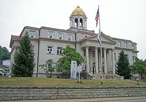
Boone County Courthouse in Madison
|
||
|
||

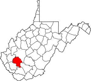
Location within the U.S. state of West Virginia
|
||
 West Virginia's location within the U.S. |
||
| Country | ||
| State | ||
| Founded | March 11, 1847 | |
| Named for | Daniel Boone | |
| Seat | Madison | |
| Largest city | Madison | |
| Area | ||
| • Total | 503.19 sq mi (1,303.3 km2) | |
| • Land | 501.53 sq mi (1,299.0 km2) | |
| • Water | 1.66 sq mi (4.3 km2) | |
| Population
(2020)
|
||
| • Total | 21,809 | |
| • Estimate
(2021)
|
21,312 |
|
| • Density | 43.48/sq mi (16.79/km2) | |
| Time zone | UTC−5 (Eastern) | |
| • Summer (DST) | UTC−4 (EDT) | |
| Congressional district | 1st | |
Boone County is a county in the U.S. state of West Virginia. As of the 2020 census, about 21,809 people lived here. Its main town, or county seat, is Madison. Boone County is part of the larger Charleston, WV Metropolitan Statistical Area.
The county's leading industries include coal mining, lumber production, and natural gas extraction. Farmers in Boone County also grow crops like tobacco and strawberries.
Contents
History of Boone County
How Boone County Was Formed
Boone County was created in 1847. It was made from parts of three other counties: Kanawha, Cabell, and Logan. The county was named after the famous frontiersman, Daniel Boone. He lived in the Great Kanawha Valley area from 1789 to 1795.
Changes in Local Government
In 1863, West Virginia divided its counties into smaller areas called civil townships. The idea was to help local governments work better. But this plan was hard to follow in a state with many rural areas. So, in 1872, these townships became "magisterial districts."
Boone County first had five districts: Crook, Peytona, Scott, Sherman, and Washington. Later, between 1980 and 1990, the county was reorganized. It was then divided into three new magisterial districts: District 1, District 2, and District 3.
Important Mining Events
On February 1, 2006, two serious mining accidents happened in Boone County. These occurred in the communities of Uneeda and Wharton. Because of these and other mining accidents that year, West Virginia Governor Joe Manchin ordered all mines in the state to temporarily close. This was done to improve mine safety.
Geography and Landscape
Boone County is located in the central southwestern part of West Virginia. The land here has low, wooded mountains with many valleys and streams. The land generally slopes down towards the north and west. The highest point in the county is in its southern corner, reaching about 3,212 feet (979 meters) above sea level.
The county covers a total area of about 503 square miles (1,300 square kilometers). Most of this, about 502 square miles (1,300 square kilometers), is land. Only a small part, about 1.7 square miles (4.4 square kilometers), is water.
Major Roads in Boone County
Neighboring Counties
- Kanawha County - northeast
- Raleigh County - east
- Wyoming County - south
- Logan County - west
- Lincoln County - northwest
Population Information
| Historical population | |||
|---|---|---|---|
| Census | Pop. | %± | |
| 1850 | 3,237 | — | |
| 1860 | 4,840 | 49.5% | |
| 1870 | 4,553 | −5.9% | |
| 1880 | 5,824 | 27.9% | |
| 1890 | 6,885 | 18.2% | |
| 1900 | 8,194 | 19.0% | |
| 1910 | 10,331 | 26.1% | |
| 1920 | 15,319 | 48.3% | |
| 1930 | 24,586 | 60.5% | |
| 1940 | 28,556 | 16.1% | |
| 1950 | 33,173 | 16.2% | |
| 1960 | 28,764 | −13.3% | |
| 1970 | 25,118 | −12.7% | |
| 1980 | 30,447 | 21.2% | |
| 1990 | 25,870 | −15.0% | |
| 2000 | 25,535 | −1.3% | |
| 2010 | 24,629 | −3.5% | |
| 2020 | 21,809 | −11.4% | |
| 2021 (est.) | 21,312 | −13.5% | |
| US Decennial Census 1790–1960 1900–1990 1990–2000 2010–2020 |
|||
2010 Census Details
According to the census from 2010, Boone County had 24,629 people. There were 9,928 households and 7,014 families living in the county. The population density was about 49.1 people per square mile (19.0 people per square kilometer).
Most of the people in the county were white (98.5%). A small percentage were black or African American (0.5%), Asian (0.1%), or American Indian (0.1%). About 0.4% of the population identified as Hispanic or Latino.
The average age of people in Boone County was 40.7 years. About 32.2% of households had children under 18 living with them. The median income for a household was $39,783, and for a family, it was $47,981.
Education in Boone County
Schools in Madison
- Brookview Elementary School
- Madison Elementary School
- Ramage Elementary School
- Madison Middle School
- Scott High School
Schools in Van
- Van Elementary School
- Van Jr./Sr. High School
Schools in Seth
- Ashford-Rumble Elementary School
- Sherman Elementary School
- Whitesville Elementary School
- Sherman Junior High School
- Sherman Senior High School
Communities in Boone County
City
- Madison (This is the county seat, where the main government offices are.)
Towns
Magisterial Districts
- District 1
- District 2
- District 3
Census-Designated Places (CDPs)
These are areas that are like towns but are not officially incorporated as cities or towns.
Unincorporated Communities
These are smaller communities that do not have their own local government.
- Andrew
- Ashford
- Bald Knob
- Bandytown
- Barrett
- Bigson
- Bim
- Bloomingrose
- Blue Pennant
- Bob White
- Bradley
- Brushton
- Cameo
- Cazy
- Clinton
- Clothier
- Coopertown
- Dartmont
- Drawdy
- Easly
- Eden
- Elk Run Junction
- Emmons (part)
- Foch
- Foster
- Fosterville
- Garrison
- Gordon
- Grippe
- Havana
- Hewett
- Hopkins Fork
- Janie
- Jeffrey
- Julian
- Keith
- Kirbyton
- Kohlsaat
- Lanta
- Lick Creek
- Lindytown
- Low Gap
- Manila
- Marnie
- Marthatown
- Maxine
- Milltown
- Morrisvale
- Nellis
- Nelson
- Onego
- Orgas
- Ottawa
- Peytona
- Pondco
- Powell Creek
- Prenter
- Price Hill
- Quinland
- Ramage
- Ridgeview
- Rumble
- Secoal
- Seth
- Sharlow
- South Madison
- Turtle Creek
- Uneeda
- Washington Heights
- West Junction
- Wharton
- Williams Mountain
Notable People from Boone County
- Hasil Adkins, a musician
- Billy Edd Wheeler, a songwriter
- D. Ray White, a mountain dancer and father of Jesco White
- Jesco White, known as "the Dancing Outlaw," also a mountain dancer and son of D. Ray White
See also
 In Spanish: Condado de Boone (Virginia Occidental) para niños
 | Roy Wilkins |
 | John Lewis |
 | Linda Carol Brown |


