Danville, West Virginia facts for kids
Quick facts for kids
Danville, West Virginia
|
||
|---|---|---|

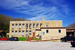
Danville Community Center
|
||
|
||

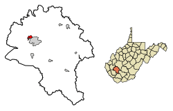
Location of Danville in Boone County, West Virginia.
|
||
| Country | United States | |
| State | West Virginia | |
| County | Boone | |
| Area | ||
| • Total | 1.08 sq mi (2.81 km2) | |
| • Land | 1.07 sq mi (2.77 km2) | |
| • Water | 0.01 sq mi (0.04 km2) | |
| Elevation | 699 ft (213 m) | |
| Population
(2020)
|
||
| • Total | 660 | |
| • Estimate
(2021)
|
645 | |
| • Density | 562.62/sq mi (217.24/km2) | |
| Time zone | UTC-5 (Eastern (EST)) | |
| • Summer (DST) | UTC-4 (EDT) | |
| ZIP code |
25053
|
|
| Area code(s) | 304 | |
| FIPS code | 54-20212 | |
| GNIS feature ID | 1537999 | |
Danville is a small town in Boone County, West Virginia, United States. In 2020, about 660 people lived there.
The town of Danville was officially created in 1911. It was named after Dan Rock, who was the first postmaster in the area. Before being called Danville, the town had other names like Newport and Red House.
Contents
Where is Danville Located?
Danville is in the northwestern part of Boone County. It sits along the Little Coal River. The main part of town, where businesses are, is mostly on the east side of the river.
Madison, which is the main town for the county (called the county seat), is right next to Danville on its south side.
Roads and Travel
West Virginia Route 85 goes through Danville. In town, this road is called Smoot Avenue. It connects Danville to Madison in the south. Route 85 also ends at U.S. Route 119 on the north side of Danville.
From this meeting point, US 119 goes northeast towards Charleston. It also goes southwest to towns like Chapmanville and Logan.
How Big is Danville?
The United States Census Bureau says that Danville covers about 1.08 square miles (2.81 square kilometers). Most of this area, about 1.07 square miles (2.77 square kilometers), is land. Only a tiny part, about 0.01 square miles (0.04 square kilometers), is water.
Who Lives in Danville?
The number of people living in Danville has changed over the years. Here's a quick look at the population from different census counts:
| Historical population | |||
|---|---|---|---|
| Census | Pop. | %± | |
| 1920 | 327 | — | |
| 1930 | 486 | 48.6% | |
| 1940 | 417 | −14.2% | |
| 1950 | 544 | 30.5% | |
| 1960 | 507 | −6.8% | |
| 1970 | 580 | 14.4% | |
| 1980 | 727 | 25.3% | |
| 1990 | 595 | −18.2% | |
| 2000 | 550 | −7.6% | |
| 2010 | 691 | 25.6% | |
| 2020 | 660 | −4.5% | |
| 2021 (est.) | 645 | −6.7% | |
| U.S. Decennial Census | |||
What the Numbers Showed in 2010
In 2010, the census counted 691 people living in Danville. These people lived in 303 homes. About 150 of these homes were families.
Most of the people in Danville were White (98.1%). A small number were African American (0.6%), Asian (0.3%), or from other backgrounds. About 1.3% of the people were of Hispanic or Latino heritage.
The average age of people in Danville was about 53.6 years old.
- About 14.8% of residents were younger than 18.
- About 6.6% were between 18 and 24 years old.
- About 18.9% were between 25 and 44 years old.
- About 28.4% were between 45 and 64 years old.
- About 31.4% were 65 years old or older.
More women lived in Danville than men in 2010. About 55.9% of the population was female, and 44.1% was male.
Helping the Community
Danville has a volunteer fire department. It is called the Danville Volunteer Fire Department. This department is made up entirely of volunteers. They help keep the town safe.
The department's yearly budget is about $150,000. They provide fire protection and rescue services. They cover the town of Danville and the areas around it. This includes about 30 miles (48 kilometers) of Route 119.
See also
 In Spanish: Danville (Virginia Occidental) para niños
 | Sharif Bey |
 | Hale Woodruff |
 | Richmond Barthé |
 | Purvis Young |


