
Chapmanville, West Virginia facts for kids
Quick facts for kids
Chapmanville, West Virginia
|
|||||
|---|---|---|---|---|---|

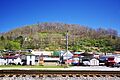
Chapmanville
|
|||||
|
|||||

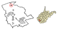
Location of Chapmanville in Logan County, West Virginia.
|
|||||
| Country | United States | ||||
| State | West Virginia | ||||
| County | Logan | ||||
| Government | |||||
| • Type | Mayor, Council | ||||
| Area | |||||
| • Total | 0.68 sq mi (1.76 km2) | ||||
| • Land | 0.66 sq mi (1.70 km2) | ||||
| • Water | 0.02 sq mi (0.06 km2) | ||||
| Elevation | 640 ft (195 m) | ||||
| Population
(2020)
|
|||||
| • Total | 1,025 | ||||
| • Estimate
(2021)
|
1,001 | ||||
| • Density | 1,665.14/sq mi (642.93/km2) | ||||
| Time zone | UTC-5 (Eastern (EST)) | ||||
| • Summer (DST) | UTC-4 (EDT) | ||||
| ZIP code |
25508
|
||||
| Area code(s) | 304 & 681 | ||||
| FIPS code | 54-14524 | ||||
| GNIS feature ID | 1537207 | ||||
| Website | https://townofchapmanville.com | ||||


Chapmanville is a town located in Logan County, West Virginia, in the United States. In 2020, about 1,025 people lived there.
The town is named after Ned Chapman, who was an early settler. He ran a store and a post office in the area. Chapmanville officially became a town in 1947.
Contents
Exploring Chapmanville's Location
Chapmanville is in the northern part of Logan County. It sits near where Crawley Creek and Godby Branch meet the Guyandotte River. The river flows north, but it makes a sharp turn southwest here before heading north again.
Two important roads, U.S. Route 119 and West Virginia Route 10, meet in Chapmanville. Both roads come from Logan to the south. From this meeting point, WV 10 goes north towards Huntington, and US 119 turns northeast towards Charleston.
The United States Census Bureau says that Chapmanville covers about 0.67 square miles (1.74 square kilometers). Most of this area is land, with a small part being water.
People of Chapmanville
| Historical population | |||
|---|---|---|---|
| Census | Pop. | %± | |
| 1950 | 1,349 | — | |
| 1960 | 1,241 | −8.0% | |
| 1970 | 1,175 | −5.3% | |
| 1980 | 1,164 | −0.9% | |
| 1990 | 1,110 | −4.6% | |
| 2000 | 1,211 | 9.1% | |
| 2010 | 1,256 | 3.7% | |
| 2020 | 1,025 | −18.4% | |
| 2021 (est.) | 1,001 | −20.3% | |
| U.S. Decennial Census | |||
In 2010, there were 1,256 people living in Chapmanville. Most people were White (98.2%). A small number of people were African American, Asian, or from other backgrounds. About 1.4% of the population was Hispanic or Latino.
The average age in town was about 42 years old. Many people lived in families, and some lived alone.
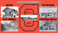
Chapmanville's Past
Early Visitors and Settlers
The first known European-American visitor to the area that is now Chapmanville was Captain Henry Farley. He was a soldier from the Revolutionary War. In 1792, he came through the area while chasing a group of Native Americans.
The Chapman and Ferrell families were among the first to settle here. Other important early families included the Butcher, Conley, Dingess, Godby, and Stollings families.
Chapmanville During the Civil War
During the American Civil War, most people in Chapmanville supported the Confederacy. A battle called the Battle of Kanawha Gap happened here on September 25, 1861. There's a special marker on the highway that tells about this battle.
A local group that supported the Confederacy, called the Black-Striped Company, was active in the area. There's a story that Union soldiers buried gold coins from their payroll on the west side of the river in Chapmanville, but it's just a legend!
Education in Chapmanville
Chapmanville is home to several schools, and they all use the tiger as their mascot!
- Chapmanville Regional High School: This is a high school for grades 9-12. It's special because it was West Virginia's first high school created by combining schools from different counties. It opened in 2007 and is one of the largest schools in the county.
- Chapmanville Middle School: This school is for students in grades 5-8.
- Chapmanville Intermediate School
- Chapmanville Primary School
Town Leaders
Chapmanville is run by a mayor and a town council. These people are elected by the citizens to help make decisions for the town.
- Current Leaders (2023-2027):
- Mayor: Joel S. McNeely
- Recorder: Phillip Williamson II
- Council Members: Harry Freeman, Dean "Doc" Williams, Brookie Craddock, Ben DesRocher, George Cook
Fun and Culture
Chapmanville has some fun traditions and places:
- Apple Butter Festival: Every September, the town hosts this festival.
- Wallace Horn Friendly Neighbor Radio Show: This radio show is also based in Chapmanville.
Outdoor Activities
If you like being outdoors, Chapmanville offers:
- Hatfield-McCoy Trails: The town recently got a connection to these popular trails, which are great for ATVs and dirt bikes.
- Guyandotte River Access: The West Virginia Department of Natural Resources (WV DNR) provides public access to the river in Chapmanville, which is good for fishing or enjoying the water.
Famous People from Chapmanville
Many notable people have come from Chapmanville, including:
- Shane Burton: A retired professional football player.
- Charles Mobley Gore, Jr.: A country music performer who also served in the state legislature.
- Danny Godby: A player in Major League Baseball.
- Earl Ray Tomblin: A former Governor of West Virginia.
- Chris Ojeda: A musician from the band Byzantine.
Images for kids
-
Chapmanville
-
Flag of Chapmanville
-
Seal of Chapmanville
-

Logo of Chapmanville
-
Location of Chapmanville in Logan County, West Virginia
See also
 In Spanish: Chapmanville (Virginia Occidental) para niños
