Wyoming County, West Virginia facts for kids
Quick facts for kids
Wyoming County
|
||
|---|---|---|

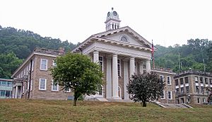
Wyoming County Courthouse and Jail in Pineville
|
||
|
||

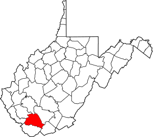
Location within the U.S. state of West Virginia
|
||
 West Virginia's location within the U.S. |
||
| Country | ||
| State | ||
| Founded | January 26, 1850 | |
| Seat | Pineville | |
| Largest city | Mullens | |
| Area | ||
| • Total | 502 sq mi (1,300 km2) | |
| • Land | 499 sq mi (1,290 km2) | |
| • Water | 2.4 sq mi (6 km2) 0.5%% | |
| Population
(2020)
|
||
| • Total | 21,382 | |
| • Estimate
(2021)
|
21,051 |
|
| • Density | 42.59/sq mi (16.445/km2) | |
| Time zone | UTC−5 (Eastern) | |
| • Summer (DST) | UTC−4 (EDT) | |
| Congressional district | 1st | |
Wyoming County is a special area in the state of West Virginia, USA. It's like a big neighborhood with its own local government. In 2020, about 21,382 people lived here. The main town, or county seat, is Pineville.
Wyoming County was created in 1850. It was formed from a part of Logan County. The name "Wyoming" comes from a word used by the Lenape people. It means "large plains," even though the county is quite mountainous!
Contents
Exploring Wyoming County's Geography
Wyoming County covers a total area of about 502 square miles. Most of this is land, about 499 square miles. A small part, about 2.4 square miles, is water. This means about 0.5% of the county is water.
The county has many mountains and is drained by rivers. These include branches of the Sandy River and the Guyandotte River. The land here is mostly hilly and rugged.
How the County is Divided
In 1863, West Virginia tried to divide its counties into smaller areas. These were called townships. The idea was to help local governments work better. But this plan didn't work well in rural areas like Wyoming County.
So, in 1872, the townships became "magisterial districts." Wyoming County first had six of these districts:
- Barkers Ridge
- Center
- Clear Fork
- Huff Creek
- Oceana
- Slab Fork
Later, in 1881, a seventh district called Baileysville was added. It was made from parts of Clear Fork and Huff Creek. These seven districts stayed mostly the same for over 100 years.
In the 1990s, these seven districts were combined. They became three new, larger districts:
- District 1
- District 2
- District 3
Main Roads in Wyoming County
Many important roads help people travel through Wyoming County. These roads connect different towns and areas. They are like the county's main arteries for transportation.
- U.S. Route 52
- West Virginia Route 10
- West Virginia Route 16
- West Virginia Route 54
- West Virginia Route 80
- West Virginia Route 85
- West Virginia Route 97
- West Virginia Route 99
- West Virginia Route 121
- West Virginia Route 971
Neighboring Counties
Wyoming County shares its borders with several other counties. Knowing its neighbors helps you understand its location better.
- Boone County (to the north)
- Raleigh County (to the northeast)
- Mercer County (to the southeast)
- McDowell County (to the south)
- Mingo County (to the west)
- Logan County (to the northwest)
People of Wyoming County
The number of people living in Wyoming County has changed over time. Here's a look at the population from past records:
| Historical population | |||
|---|---|---|---|
| Census | Pop. | %± | |
| 1850 | 1,645 | — | |
| 1860 | 2,861 | 73.9% | |
| 1870 | 3,171 | 10.8% | |
| 1880 | 4,322 | 36.3% | |
| 1890 | 6,247 | 44.5% | |
| 1900 | 8,380 | 34.1% | |
| 1910 | 10,392 | 24.0% | |
| 1920 | 15,180 | 46.1% | |
| 1930 | 20,926 | 37.9% | |
| 1940 | 29,774 | 42.3% | |
| 1950 | 37,540 | 26.1% | |
| 1960 | 34,836 | −7.2% | |
| 1970 | 30,095 | −13.6% | |
| 1980 | 35,993 | 19.6% | |
| 1990 | 28,990 | −19.5% | |
| 2000 | 25,708 | −11.3% | |
| 2010 | 23,796 | −7.4% | |
| 2020 | 21,382 | −10.1% | |
| 2021 (est.) | 21,051 | −11.5% | |
| U.S. Decennial Census 1790–1960 1900–1990 1990–2000 2010–2020 |
|||
What the 2010 Census Showed
The 2010 United States census counted 23,796 people in Wyoming County. There were 9,687 households, which are groups of people living together. About 6,947 of these were families.
The county had about 47.6 people per square mile. There were also 10,958 housing units, like houses or apartments.
Most people in the county were white (98.2%). Small percentages were Black or African American (0.5%), Asian (0.1%), or American Indian (0.1%). About 1.0% of people were from two or more races. People of Hispanic or Latino origin made up 0.4% of the population.
Many people in the county have Irish, English, American, or German family backgrounds.
About 30.8% of households had children under 18 living with them. More than half (56.3%) were married couples. The average household had 2.45 people. Families, on average, had 2.90 people. The median age of people in the county was 42.6 years.
The median income for a household was $36,343. For a family, it was $46,221. This means half of the households earned more than this amount, and half earned less. The income per person in the county was $17,662.
About 17.3% of all people in the county lived below the poverty line. This included 24.4% of those under 18 years old. For people aged 65 or older, 8.9% were below the poverty line.
Communities in Wyoming County
Wyoming County has different types of communities. These include cities, towns, and smaller places.
City
Towns
Magisterial Districts
These are the areas the county is divided into for local government.
Current Districts
- District 1
- District 2
- District 3
Historic Districts
- Baileysville
- Barkers Ridge
- Center
- Clear Fork
- Huff
- Oceana
- Slab Fork
Census-Designated Places (CDPs)
These are areas that are like towns but are not officially incorporated as cities or towns. They are defined by the U.S. Census Bureau for statistical purposes.
Unincorporated Communities
These are smaller settlements that are not part of any city or town.
- Allen Junction
- Alpoca
- Amigo
- Baileysville
- Beechwood
- Black Eagle
- Clear Fork
- Coal Mountain
- Crany
- Cyclone
- Fanny
- Fanrock
- Garwood
- Glen Rogers
- Glover
- Hanover
- Herndon
- Ikes Fork
- Jesse
- Key Rock
- Lacoma
- Lynco
- Maben
- Marianna
- McGraws-Tipple
- Milam
- North Spring
- Otsego
- Pierpont
- Ravencliff
- Rock View
- Sabine
- Saulsville
- Simon
- Stephenson
- Tralee
- Windom
- Wolf Pen
- Wyco
- Wyoming
Famous People from Wyoming County
Many talented people have come from Wyoming County. They have made a name for themselves in sports, entertainment, and other fields.
- Bernie Casey: A football player who also became an actor.
- Mike D'Antoni: A well-known coach in the NBA (National Basketball Association).
- William C. Marland: A former Governor of West Virginia.
- Christy Martin: A professional boxer.
- Jamie Noble: A professional wrestler.
- Joe Pendry: A coach in the NFL (National Football League).
- Heath Slater: A professional wrestler.
- Curt Warner: A football player.
- Greg White: A college basketball coach and motivational speaker.
Images for kids
See also
 In Spanish: Condado de Wyoming (Virginia Occidental) para niños
 | William M. Jackson |
 | Juan E. Gilbert |
 | Neil deGrasse Tyson |


