Mercer County, West Virginia facts for kids
Quick facts for kids
Mercer County
|
|||
|---|---|---|---|

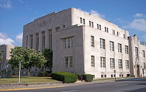
The Mercer County Courthouse in Princeton in 2007
|
|||
|
|||

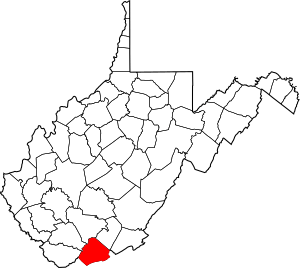
Location within the U.S. state of West Virginia
|
|||
 West Virginia's location within the U.S. |
|||
| Country | |||
| State | |||
| Founded | March 17, 1837 | ||
| Seat | Princeton | ||
| Largest town | Bluefield | ||
| Area | |||
| • Total | 421 sq mi (1,090 km2) | ||
| • Land | 419 sq mi (1,090 km2) | ||
| • Water | 1.7 sq mi (4 km2) 0.4%% | ||
| Population
(2020)
|
|||
| • Total | 59,664 | ||
| • Estimate
(2021)
|
59,097 |
||
| • Density | 141.72/sq mi (54.72/km2) | ||
| Time zone | UTC−5 (Eastern) | ||
| • Summer (DST) | UTC−4 (EDT) | ||
| Congressional district | 1st | ||
Mercer County is a county in Southern West Virginia. It is located on the southeastern border of the U.S. state of West Virginia. In 2020, about 59,664 people lived there.
The county seat, or main city for government, is Princeton. Mercer County was created on March 17, 1837. It was formed from parts of Giles and Tazewell counties in the State of Virginia.
Mercer County is also part of the Bluefield, WV-VA area. This area is known as a "Micropolitan Statistical Area."
Contents
History of Mercer County
Mercer County was named after Hugh Mercer. He was an important general during the American Revolutionary War.
Geography of Mercer County
Mercer County covers a total area of about 421 square miles. Most of this area, 419 square miles, is land. Only a small part, about 1.7 square miles, is water.
In the past, West Virginia counties were divided into "civil townships." This was meant to help local governments. But it was hard to do in rural areas. So, in 1872, these townships became "magisterial districts."
Mercer County first had five districts. These were Beaver Pond, East River, Jumping Branch, Plymouth, and Rock. In the 1970s, these five districts were combined. They became three new districts: District 1, District 2, and District 3. Later, in the 1980s, they were renamed "District I," "District II," and "District III."
Main Roads in Mercer County
Many important roads run through Mercer County. These roads help people travel and transport goods.
The West Virginia Turnpike starts in Princeton. This turnpike is now part of Interstate 77.
Neighboring Counties
Mercer County shares its borders with several other counties.
- Raleigh County (to the north)
- Summers County (to the northeast)
- Giles County, Virginia (to the east)
- Bland County, Virginia (to the south)
- Tazewell County, Virginia (to the southwest)
- McDowell County (to the west)
- Wyoming County (to the northwest)
Protected Natural Areas
Part of the Bluestone National Scenic River is located in Mercer County. This area is protected for its natural beauty.
Population and People
| Historical population | |||
|---|---|---|---|
| Census | Pop. | %± | |
| 1840 | 2,233 | — | |
| 1850 | 4,222 | 89.1% | |
| 1860 | 6,819 | 61.5% | |
| 1870 | 7,064 | 3.6% | |
| 1880 | 7,467 | 5.7% | |
| 1890 | 16,002 | 114.3% | |
| 1900 | 23,023 | 43.9% | |
| 1910 | 38,371 | 66.7% | |
| 1920 | 49,558 | 29.2% | |
| 1930 | 61,323 | 23.7% | |
| 1940 | 68,289 | 11.4% | |
| 1950 | 75,013 | 9.8% | |
| 1960 | 68,206 | −9.1% | |
| 1970 | 63,206 | −7.3% | |
| 1980 | 73,942 | 17.0% | |
| 1990 | 64,980 | −12.1% | |
| 2000 | 62,980 | −3.1% | |
| 2010 | 62,264 | −1.1% | |
| 2020 | 59,664 | −4.2% | |
| 2021 (est.) | 59,097 | −5.1% | |
| U.S. Decennial Census 1790–1960 1900–1990 1990–2000 2010–2020 |
|||
2010 Census Information
In 2010, there were 62,264 people living in Mercer County. There were 26,603 households, which are groups of people living together. About 17,313 of these were families.
The population density was about 148.6 people per square mile. Most people in the county, 91.6%, were white. About 6.1% were black or African American. Other groups included Asian (0.5%) and American Indian (0.2%). About 1.4% of people were from two or more races. People of Hispanic or Latino background made up 0.8% of the population.
Many people in Mercer County have Irish, German, English, or American family roots.
In 2010, about 27.8% of households had children under 18 living there. About 47.6% were married couples. The average household had 2.30 people. The average family had 2.83 people. The average age of people in the county was 42.5 years old.
Education in Mercer County
The Mercer County Public School System helps educate many students. It has nineteen elementary schools. Some of these include Athens, Bluewell, and Princeton Primary.
There are also six middle schools. These include Princeton Middle and Bluefield Middle. The county has four high schools. These are Princeton Senior, Bluefield High, Montcalm High, and PikeView High.
The Mercer County Technical Education Center is becoming a full technical high school. Overall, Mercer County Schools teaches about 9,200 students. Around 1,200 staff members work in the schools.
Mercer County also has colleges. These include Bluefield State College in Bluefield. There is also Concord University in Athens. New River Community and Technical College is located in Princeton.
Law Enforcement
Mercer County is kept safe by several law enforcement groups. The main group for areas outside of cities is the Mercer County Sheriff's Department. This department has about 30 police officers. They also have other staff members.
The Sheriff's Department has special teams. These include a K-9 Unit with police dogs. They also have a Detective Bureau to investigate crimes. A SWAT team helps with dangerous situations.
The West Virginia State Police also has a detachment in Princeton. There is also a Turnpike Detachment that patrols the highways.
Communities in Mercer County
Cities
- Bluefield (This is the largest city in the county.)
- Princeton (This is where the county government is located.)
Towns
Magisterial Districts
- District I
- District II
- District III
Census-Designated Places
These are areas that are like towns but are not officially incorporated.
See also
 In Spanish: Condado de Mercer (Virginia Occidental) para niños
 | Janet Taylor Pickett |
 | Synthia Saint James |
 | Howardena Pindell |
 | Faith Ringgold |


