
Bramwell, West Virginia facts for kids
Quick facts for kids
Bramwell, West Virginia
|
|
|---|---|

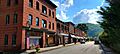
Bramwell, with the Bluestone River in the foreground
|
|

Location of Bramwell in Mercer County, West Virginia.
|
|
| Country | United States |
| State | West Virginia |
| County | Mercer |
| Area | |
| • Total | 0.58 sq mi (1.51 km2) |
| • Land | 0.56 sq mi (1.44 km2) |
| • Water | 0.03 sq mi (0.08 km2) |
| Elevation | 2,244 ft (684 m) |
| Population
(2020)
|
|
| • Total | 277 |
| • Estimate
(2021)
|
274 |
| • Density | 607.21/sq mi (234.60/km2) |
| Time zone | UTC-5 (Eastern (EST)) |
| • Summer (DST) | UTC-4 (EDT) |
| ZIP code |
24715
|
| Area code(s) | 304, 681 |
| FIPS code | 54-09796 |
| GNIS feature ID | 2390747 |
| Website | https://www.bramwellwestva.com |
Bramwell is a small town in Mercer County, West Virginia, United States. It is located right next to the Bluestone River. In 2020, about 277 people lived there. Bramwell is also part of the larger Bluefield area, which has over 100,000 people.
Contents
History of Bramwell
In the 1880s, the area around Bramwell started to grow very quickly. This was because of the many coal mines opening up nearby. The town of Bramwell was officially started in 1888. It was named after J.H. Bramwell, who was a civil engineer.
In the late 1800s, Bramwell became famous for something special. It had the most millionaires per person in the United States! Many rich coal mine owners built large, fancy homes in the town.
On January 7, 1910, a big fire destroyed part of the town center. Twenty-one buildings burned down. Later, in 1984, the U.S. Department of the Interior recognized Bramwell as a National Historic Place. Many of its houses were built in the early 1900s. Today, there is a museum in Bramwell. It teaches visitors about the town's history with coal mining and trains.
Exploring Bramwell's Geography
Bramwell is located along the Bluestone River. It is just east of the border between Virginia and West Virginia. U.S. Route 52 goes through the eastern part of Bramwell. This road connects the town to Bluefield in the south. It also connects to Northfork in the northwest. Just southeast of Bramwell, you can find Pinnacle Rock State Park.
The town covers about 0.59 square miles (1.53 km2) of land and water. Most of this area, about 0.56 square miles (1.45 km2), is land. The rest, about 0.03 square miles (0.08 km2), is water.
Bramwell is also very close to the Pocahontas Trail system. This system is part of the Hatfield-McCoy trails. These trails are over 700 miles (1127 km) long. They are mostly rough roads used by dirt bikes and ATVs (All-Terrain Vehicles). The Hatfield-McCoy Regional Trail Authority manages these exciting trails.
Population Facts
| Historical population | |||
|---|---|---|---|
| Census | Pop. | %± | |
| 1890 | 499 | — | |
| 1900 | 825 | 65.3% | |
| 1910 | 1,458 | 76.7% | |
| 1920 | 1,690 | 15.9% | |
| 1930 | 1,574 | −6.9% | |
| 1940 | 1,494 | −5.1% | |
| 1950 | 1,587 | 6.2% | |
| 1960 | 1,195 | −24.7% | |
| 1970 | 1,125 | −5.9% | |
| 1980 | 989 | −12.1% | |
| 1990 | 620 | −37.3% | |
| 2000 | 426 | −31.3% | |
| 2010 | 364 | −14.6% | |
| 2020 | 277 | −23.9% | |
| 2021 (est.) | 274 | −24.7% | |
| U.S. Decennial Census | |||
How Many People Live Here?
In 2010, there were 364 people living in Bramwell. These people lived in 164 homes. About 105 of these were families. The town had about 650.0 inhabitants per square mile (251.0/km2) people per square mile.
Most of the people in Bramwell were White (96.4%). A small number were African American (3.3%). About 0.3% were from two or more races. Also, 0.3% of the people were Hispanic or Latino.
In 2010, the average age in Bramwell was about 49.7 years old.
- About 16.2% of residents were under 18 years old.
- About 6.5% were between 18 and 24 years old.
- About 22.5% were between 25 and 44 years old.
- About 31.5% were between 45 and 64 years old.
- About 23.1% were 65 years old or older.
There were slightly more females (52.7%) than males (47.3%) living in Bramwell.
Images for kids
-
Bramwell Main Street

See also
 In Spanish: Bramwell (Virginia Occidental) para niños
