Lashmeet, West Virginia facts for kids
Quick facts for kids
Lashmeet
|
|
|---|---|
|
Census-designated place (CDP)
|
|

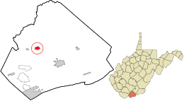
Location in Mercer County and the state of West Virginia.
|
|
| Country | United States |
| State | West Virginia |
| County | Mercer |
| Area | |
| • Total | 0.750 sq mi (1.94 km2) |
| • Land | 0.750 sq mi (1.94 km2) |
| • Water | 0 sq mi (0 km2) |
| Elevation | 2,533 ft (772 m) |
| Population
(2010)
|
|
| • Total | 479 |
| • Density | 638.7/sq mi (246.6/km2) |
| Time zone | UTC-5 (Eastern (EST)) |
| • Summer (DST) | UTC-4 (EDT) |
| ZIP codes |
24733
|
| GNIS feature ID | 2586841 |
Lashmeet is a small community located in Mercer County, West Virginia, in the United States. It is known as a census-designated place (CDP). This means it is an area that looks like a town but is not officially governed as one.
Where Did Lashmeet Get Its Name?
The name Lashmeet most likely comes from a local family. People in the area used to call them the Lashmeet or Lashmutt family.
Location and People of Lashmeet
Lashmeet is found in the western part of Mercer County. It sits along West Virginia Route 10. This road is northwest of Princeton, which is the main city and county seat for Mercer County.
Even though Lashmeet is not an official town, it has its own post office. The ZIP code for Lashmeet is 24733. According to the 2010 census, 479 people lived in Lashmeet.
See also
 In Spanish: Lashmeet (Virginia Occidental) para niños
 | Valerie Thomas |
 | Frederick McKinley Jones |
 | George Edward Alcorn Jr. |
 | Thomas Mensah |

