Harts, West Virginia facts for kids
Quick facts for kids
Harts, West Virginia
|
|
|---|---|

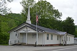
Harts Baptist Church
|
|

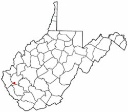
Location of Harts, West Virginia
|
|
| Country | United States |
| State | West Virginia |
| County | Lincoln |
| Area | |
| • Total | 9.31 sq mi (24.12 km2) |
| • Land | 9.18 sq mi (23.77 km2) |
| • Water | 0.14 sq mi (0.35 km2) |
| Elevation | 630 ft (192 m) |
| Population
(2010)
|
|
| • Total | 656 |
| • Density | 71/sq mi (27.6/km2) |
| Time zone | UTC-5 (Eastern (EST)) |
| • Summer (DST) | UTC-4 (EDT) |
| ZIP code |
25524
|
| Area code(s) | 304 |
| FIPS code | 54-35596 |
| GNIS feature ID | 1540035 |
Harts is a small community in Lincoln County, West Virginia, United States. It's known as a census-designated place (CDP), which means it's a special area used for gathering population information. Harts is located where Big Harts Creek meets the Guyandotte River.
In 2010, about 656 people lived in Harts. This community is also part of a larger area called the Huntington-Ashland, WV-KY-OH, Metropolitan Statistical Area. The Harts CDP includes several smaller communities like Atenville, Ferrellsburg, and Sand Creek.
Contents
Where is Harts?
Harts is found in the southern part of Lincoln County. It's located at 38°1′50″N 82°7′41″W / 38.03056°N 82.12806°W. West Virginia Route 10 runs right through the middle of Harts, following the Guyandotte River.
This highway can take you about 44 miles (71 km) northwest to the city of Huntington. If you go southeast, it's about 10 miles (16 km) to Chapmanville.
Land and Water
The United States Census Bureau says that the Harts CDP covers a total area of about 24.1 square kilometers (9.3 square miles). Most of this area, about 23.8 square kilometers (9.2 square miles), is land. The rest, about 0.3 square kilometers (0.1 square miles), is water.
The area includes both Big Harts Creek and Little Harts Creek. There's also a part of Big Harts Creek called the West Fork. Sometimes, maps mistakenly call it the "East Fork." But it was actually named after a person named West, not because of its direction.
Who Lives in Harts?
In the year 2000, there were about 2,361 people living in the Harts area. Most of the people living there were White (99.36%).
There were 858 households, and many of them (36.2%) had children under 18 living at home. Most households (66.2%) were married couples living together. The average household had about 2.75 people.
The people in Harts were of different ages. About 24.6% were under 18, and 10.3% were 65 or older. The average age was 36 years old.
The average yearly income for a household in Harts was about $21,703. For families, it was around $24,886. About 26.2% of the people in Harts lived below the poverty line. This included 31.7% of children under 18.
A Look at Harts' Past
The town of Harts gets its name from an early settler named Stephen Hart (or Heart). Some say he lived in the area, or that his father, who was killed by Native Americans nearby, was the namesake.
Early Settlers and County Changes
The first person to settle permanently in Harts was Richard Elkins. He arrived sometime between 1807 and 1815. Back then, Harts was part of either Kanawha County or Cabell County.
Important early families who settled in Harts included the Elkins, Adkins, and Toney families. After 1824, the area became part of Logan County. Before the American Civil War, a man named Isaac Adkins owned a large farm in the area. The Isaac Adkins Shoals are named after him.
In the 1840s, James Toney bought land near Big Harts Creek, across the river from Adkins' farm. During the Civil War, most local men joined the Confederate States Army.
Harts Joins Lincoln County
In 1869, Harts became part of Lincoln County. Over the years, several post offices were opened and closed in the area:
- In 1870, Henry S. Godby opened the Hearts Creek Post Office, but it closed in 1872.
- In 1877, William T. "Bill" Fowler opened the Hart's Creek Post Office, which closed in 1880.
- In 1881, Andrew D. Robinson opened the Hart Post Office.
- In 1910, the Hart Post Office closed.
- In 1916, Lewis Dempsey opened the Harts Post Office, which is still open today.
During the 1880s, there were some disagreements and conflicts in the Lincoln County area, including Harts, that were reported in newspapers.
In the 1890s, Al and Hollena Brumfield were well-known residents. In 1904, the C&O Railroad built tracks through the town, which helped connect Harts to other places. Many important merchants, like F.E. Adkins and L.T. Jones, ran businesses in Harts during this time and in later years.
Wider Harts Community
The Harts Creek community is larger than just the CDP. It includes parts of Lincoln County and Logan County. Many smaller communities, like Atenville, Ferrellsburg, and Sand Creek, are part of this wider area.
The community also includes many different creeks and branches, such as Big Harts Creek, Little Harts Creek, and Sand Creek. Before 1840, many families lived in these areas, including the Brumfield, Elkins, Adkins, and Toney families. Most of the early settlers were from England.
See also
 In Spanish: Harts (Virginia Occidental) para niños
 | Delilah Pierce |
 | Gordon Parks |
 | Augusta Savage |
 | Charles Ethan Porter |

