Ceredo, West Virginia facts for kids
Quick facts for kids
Ceredo, West Virginia
|
|||||
|---|---|---|---|---|---|
|
Town
|
|||||

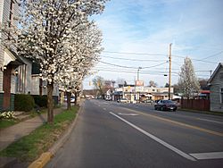
Looking east along U.S. Route 60 from C Street
|
|||||
|
|||||

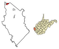
Location of Ceredo in Wayne County, West Virginia.
|
|||||
| Country | United States | ||||
| State | West Virginia | ||||
| County | Wayne | ||||
| Area | |||||
| • Total | 2.04 sq mi (5.29 km2) | ||||
| • Land | 1.31 sq mi (3.40 km2) | ||||
| • Water | 0.73 sq mi (1.89 km2) | ||||
| Elevation | 551 ft (168 m) | ||||
| Population
(2020)
|
|||||
| • Total | 1,408 | ||||
| • Density | 690.20/sq mi (266.16/km2) | ||||
| Time zone | UTC-5 (Eastern (EST)) | ||||
| • Summer (DST) | UTC-4 (EDT) | ||||
| ZIP code |
25507
|
||||
| Area code(s) | 304, 681 | ||||
| FIPS code | 54-14308 | ||||
| GNIS feature ID | 1537176 | ||||
| Website | https://ceredowv.gov/ | ||||
Ceredo is a small town in Wayne County, West Virginia, United States. It is located right along the Ohio River. In 2020, about 1,408 people lived there. Ceredo is part of a larger area called the Huntington-Ashland, WV-KY-OH Metropolitan Statistical Area.
A sad event in the area's history was the Southern Airways Flight 932 plane crash. On November 14, 1970, an airplane carrying the Marshall University football team crashed nearby. All 75 people on board passed away. A movie about this tragedy, called We Are Marshall, was released in 2006.
Contents
History of Ceredo
Ceredo got its name from its founder, who saw a lot of corn growing there. The name comes from Ceres, the Roman goddess of corn and harvest.
Founding of Ceredo
New England settlers, called Congregationalists, started Ceredo. They were part of the American Emigrant Aid and Homestead Company. They wanted to show that an economy without slavery could be better. Eli Thayer, a congressman from Massachusetts who was against slavery, believed this. He thought that if people who opposed slavery moved to Southern states, slavery would eventually end peacefully.
Some people in the area welcomed these new settlers. However, some local newspapers did not like this "invasion." But a newspaper in nearby Ashland, Kentucky, supported the idea. By 1857, Ceredo was a full town with its own newspaper and several businesses. Ceredo was the only town that Thayer and his company managed to establish due to money problems.
Ceredo During the Civil War
The situation became difficult for this anti-slavery town when John Brown's raid happened in 1859. Then, the American Civil War started in 1861. The town's goal of ending slavery peacefully was no longer possible. Many residents joined regiments that supported the Union (the North).
Ceredo became a station for the Union's 5th West Virginia Infantry Regiment. Later, these soldiers moved elsewhere. The town then suffered from attacks by small groups of fighters. By the end of the war, many of the town's businesses were destroyed. Most of the settlers from the North had left.
Eli Thayer eventually gave ownership of the town to Congressman Charles B. Hoard. Hoard and his family helped rebuild Ceredo into a small town. However, it never became as big as Thayer and his company had first imagined.
Geography of Ceredo
Ceredo is located at 38°23′36″N 82°33′37″W / 38.39333°N 82.56028°W.
The United States Census Bureau says the town covers about 2.26 square miles (5.85 square kilometers). About 1.53 square miles (3.96 square kilometers) is land, and 0.73 square miles (1.89 square kilometers) is water.
Population Changes
The population of Ceredo has changed over the years. Here's how many people lived there at different times:
| Historical population | |||
|---|---|---|---|
| Census | Pop. | %± | |
| 1880 | 462 | — | |
| 1890 | 923 | 99.8% | |
| 1900 | 1,279 | 38.6% | |
| 1910 | 1,215 | −5.0% | |
| 1920 | 1,110 | −8.6% | |
| 1930 | 1,164 | 4.9% | |
| 1940 | 1,212 | 4.1% | |
| 1950 | 1,399 | 15.4% | |
| 1960 | 1,387 | −0.9% | |
| 1970 | 1,583 | 14.1% | |
| 1980 | 2,255 | 42.5% | |
| 1990 | 1,916 | −15.0% | |
| 2000 | 1,675 | −12.6% | |
| 2010 | 1,450 | −13.4% | |
| 2020 | 1,408 | −2.9% | |
| Source: | |||
Ceredo in 2010
In 2010, there were 1,450 people living in Ceredo. There were 638 households and 378 families. The town had about 948 people per square mile (366 people per square kilometer). Most residents (98.2%) were White.
About 20.7% of households had children under 18. Many households (40.9%) were married couples. About 37.0% of all households were single individuals. Also, 19.6% of households had someone aged 65 or older living alone. The average household had 2.07 people.
The average age in Ceredo was 48.9 years. About 16.1% of residents were under 18. And 26.6% were 65 years or older. More females (57.4%) lived in Ceredo than males (42.6%).
Climate
Ceredo has a humid subtropical climate. This means it has hot, humid summers. The winters are usually mild to cool. This type of climate is known as "Cfa" on climate maps.
Famous People from Ceredo
- Dagmar: A TV star from the 1950s. She lived in Ceredo later in her life.
- Charles B. Hoard: A businessman and member of the United States House of Representatives.
- Beau Smith: A comic book writer, publicist, and columnist.
- Eli Thayer: A member of the United States House of Representatives and the founder of Ceredo.
- James Dixon Williams: A pioneer in Hollywood movies. He helped start First National Pictures. He was born in Ceredo around 1877.
See also
 In Spanish: Ceredo para niños
 | Chris Smalls |
 | Fred Hampton |
 | Ralph Abernathy |


